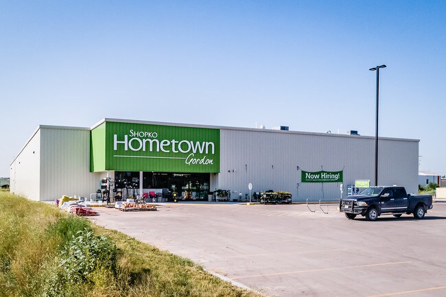
Property Record
301 E Us Highway 20 Hwy, Gordon, NE 69343


NEARBY LISTINGS FOR SALE OR LEASE
-
-
View all Gordon listings for lease on LoopNet.com
Property Detail
301 E Us Highway 20 Hwy
Other Market Areas
Barto's Subdivision In
810084031
PT OUTLOT A (E 300'X561') - BARTOS SUB -IN - GORDON IN
Wholesaleoutletdiscountstore
Sheridan
2024
Nebraska
2025
3.86 AC
951600
Nebraska Area
26,438 SF
DEMOGRAPHICS near 301 E Us Highway 20 Hwy
1 Mile
3 Mile
5 Mile
2024 Total Population
1,634
2,002
2,098
2029 Population
1,614
1,976
2,071
Pop Growth 2024-2029
(1.22%)
(1.30%)
(1.29%)
Average Age
42
42
43
2024 Total Households
674
824
865
HH Growth 2024-2029
(1.04%)
(1.09%)
(1.04%)
Median Household Inc
$47,067
$47,016
$47,197
Avg Household Size
2.30
2.30
2.30
2024 Avg HH Vehicles
2.00
2.00
2.00
Median Home Value
$81,910
$81,944
$82,486
Median Year Built
1955
1955
1955
Nearby Places
Map Layers
Map Styles
 Street
 Aerial
- Restaurants
- Banks
- Shops
- Fitness
- Groceries
SALE & LEASE HISTORY
LISTING DATE
SALE/LEASE

Oct 11, 2018
For Sale
Dec 15, 2017
For Sale
Aug 30, 2018
For Sale
Apr 17, 2019
For Lease
Apr 17, 2019
For Sale
Nearby Properties
Address
Land Use
TOTAL SIZE
Lot Size
Zoning
Address
Land Use
TOTAL SIZE
Lot Size
Zoning
6,000 SF
7.43 AC
03-COMMERC
Address
Land Use
TOTAL SIZE
Lot Size
Zoning
25,666 SF
2.42 AC
03-COMMERC
Address
Land Use
TOTAL SIZE
Lot Size
Zoning
9,000 SF
0.57 AC
03-COMMERC
Address
Land Use
TOTAL SIZE
Lot Size
Zoning
3,666 SF
1.10 AC
03-COMMERC
Address
Land Use
TOTAL SIZE
Lot Size
Zoning
12,000 SF
1.92 AC
03-COMMERC
Address
Land Use
TOTAL SIZE
Lot Size
Zoning
6,752 SF
0.17 AC
03-COMMERC
Address
Land Use
TOTAL SIZE
Lot Size
Zoning
11,859 SF
0.97 AC
03-COMMERC
Address
Land Use
TOTAL SIZE
Lot Size
Zoning
20,421 SF
2.11 AC
03-COMMERC
Address
Land Use
TOTAL SIZE
Lot Size
Zoning
1,658 SF
312.22 AC
05-AGRICUL
Address
Land Use
TOTAL SIZE
Lot Size
Zoning
11,845 SF
0.40 AC
01-SINGLE
Address
Land Use
TOTAL SIZE
Lot Size
Zoning
4,000 SF
0.37 AC
01-SINGLE
Address
Land Use
TOTAL SIZE
Lot Size
Zoning
1,800 SF
9 AC
03-COMMERC
Address
Land Use
TOTAL SIZE
Lot Size
Zoning
8,505 SF
0.39 AC
03-COMMERC
Address
Land Use
TOTAL SIZE
Lot Size
Zoning
8,056 SF
5.72 AC
04-INDUSTR
Address
Land Use
TOTAL SIZE
Lot Size
Zoning
5,250 SF
0.19 AC
01-SINGLE
Address
Land Use
TOTAL SIZE
Lot Size
Zoning
19,584 SF
0.88 AC
03-COMMERC
Address
Land Use
TOTAL SIZE
Lot Size
Zoning
3,000 SF
0.41 AC
03-COMMERC
Address
Land Use
TOTAL SIZE
Lot Size
Zoning
4,817 SF
0.12 AC
03-COMMERC
Address
Land Use
TOTAL SIZE
Lot Size
Zoning
2,772 SF
1.16 AC
03-COMMERC
Address
Land Use
TOTAL SIZE
Lot Size
Zoning
3,444 SF
1.98 AC
01-SINGLE
Address
Land Use
TOTAL SIZE
Lot Size
Zoning
4,540 SF
07-OTHER
Address
Land Use
TOTAL SIZE
Lot Size
Zoning
4,578 SF
0.98 AC
01-SINGLE
Address
Land Use
TOTAL SIZE
Lot Size
Zoning
17,296 SF
0.88 AC
03-COMMERC
Address
Land Use
TOTAL SIZE
Lot Size
Zoning
4,608 SF
0.40 AC
03-COMMERC
Address
Land Use
TOTAL SIZE
Lot Size
Zoning
20,400 SF
5.54 AC
03-COMMERC
Address
Land Use
TOTAL SIZE
Lot Size
Zoning
296.55 AC
05-AGRICUL
Address
Land Use
TOTAL SIZE
Lot Size
Zoning
5,592 SF
0.18 AC
01-SINGLE
Address
Land Use
TOTAL SIZE
Lot Size
Zoning
1,952 SF
0.22 AC
01-SINGLE
Address
Land Use
TOTAL SIZE
Lot Size
Zoning
4,200 SF
0.25 AC
03-COMMERC
The World's #1 Commercial Real Estate Marketplace
Connect with us
© 2025 CoStar Group
The information above has been obtained from sources believed reliable. While we do not doubt its accuracy we have not verified it and make no guarantee, warranty or representation about it. It is your responsibility to independently confirm its accuracy and completeness. Any projections, opinions, assumptions, or estimates used are for example only and do not represent the current or future performance of the property. The value of this transaction to you depends on tax and other factors which should be evaluated by your tax, financial, and legal advisors. You and your advisors should conduct a careful, independent investigation of the property to determine to your satisfaction the suitability of the property for your needs.