Property Record
301 E Williamsburg Rd, Sandston, VA 23150
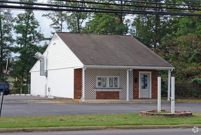


Property Detail
301 E Williamsburg Rd
828-715-8345
0164050005 0012; SANDSTON SC A BL 5 LT PT12 W 54.6FT 11 B2 8
Commercialnec
Henrico
B-1
Virginia
B and X Area of moderate flood hazard, usually the area between the limits of the 100-year and 500-year floods.
0.21 AC
2026
East End
2026
Richmond VA
201701
Richmond, VA
1,406 SF
NEARBY LISTINGS FOR SALE OR LEASE
DEMOGRAPHICS near 301 E Williamsburg Rd
1 mile
3 mile
5 mile
2025 Total Population
6,341
24,774
61,654
2030 Population
6,443
25,036
62,614
Pop Growth 2025-2030
+ 1.61%
+ 1.06%
+ 1.56%
Average Age
40
40
40
2025 Total Households
2,576
10,006
24,919
HH Growth 2025-2030
+ 1.71%
+ 1.17%
+ 1.64%
Median Household Inc
$65,924
$57,130
$65,569
Avg Household Size
2.40
2.40
2.40
2025 Avg HH Vehicles
2.00
2.00
2.00
Median Home Value
$240,509
$246,768
$266,357
Median Year Built
1971
1976
1982
Nearby Places
Map Layers
Map Styles
 Street
 Aerial
Layers
 Traffic
 Biking
Places
Listings with unknown addresses are not visible on the map
- Restaurants
- Banks
- Shops
- Fitness
- Groceries
PUBLIC TRANSPORTATION
COMMUTER RAIL
Richmond Main Street Amtrak Station (Northeast Regional - Amtrak)
Drive
Walk
Distance
Richmond Main Street Amtrak Station (Northeast Regional - Amtrak)
14 min
9.0 mi
AIRPORT
Richmond International
Drive
Walk
Distance
Richmond International
5 min
1.9 mi
Freight Ports
Virginia Port Authority - Richmond
Drive
Walk
Distance
Virginia Port Authority - Richmond
23 min
13.1 mi
Nearby Properties
Address
Land Use
TOTAL SIZE
Lot Size
Zoning
Address
Land Use
TOTAL SIZE
Lot Size
Zoning
548,680 SF
2,298.89 AC
MIXED
Address
Land Use
TOTAL SIZE
Lot Size
Zoning
272,410 SF
56.39 AC
MIXED
Address
Land Use
TOTAL SIZE
Lot Size
Zoning
84,124 SF
61.99 AC
B-3C
Address
Land Use
TOTAL SIZE
Lot Size
Zoning
141,540 SF
31.21 AC
M-1
Address
Land Use
TOTAL SIZE
Lot Size
Zoning
522,399 SF
58.07 AC
M-1
Address
Land Use
TOTAL SIZE
Lot Size
Zoning
444,069 SF
23.82 AC
M-1
Address
Land Use
TOTAL SIZE
Lot Size
Zoning
322,000 SF
15.94 AC
M-1
Address
Land Use
TOTAL SIZE
Lot Size
Zoning
181,200 SF
14.74 AC
R-5
Address
Land Use
TOTAL SIZE
Lot Size
Zoning
53,530 SF
4.50 AC
M-1C
Address
Land Use
TOTAL SIZE
Lot Size
Zoning
179,359 SF
11.85 AC
M-1
Address
Land Use
TOTAL SIZE
Lot Size
Zoning
420.71 AC
M-2
Address
Land Use
TOTAL SIZE
Lot Size
Zoning
241,800 SF
M-2C
Address
Land Use
TOTAL SIZE
Lot Size
Zoning
146,560 SF
11.09 AC
R-5
Address
Land Use
TOTAL SIZE
Lot Size
Zoning
108,738 SF
6.39 AC
R-6
Address
Land Use
TOTAL SIZE
Lot Size
Zoning
142,379 SF
17.69 AC
M-1
Address
Land Use
TOTAL SIZE
Lot Size
Zoning
137,051 SF
16.39 AC
B-3C
Address
Land Use
TOTAL SIZE
Lot Size
Zoning
69,248 SF
5.24 AC
B-3C
Address
Land Use
TOTAL SIZE
Lot Size
Zoning
144,135 SF
9.72 AC
M-1
Address
Land Use
TOTAL SIZE
Lot Size
Zoning
1,546 SF
43.18 AC
MIXED
Address
Land Use
TOTAL SIZE
Lot Size
Zoning
127,868 SF
12.85 AC
B-3C
Address
Land Use
TOTAL SIZE
Lot Size
Zoning
130,638 SF
11.06 AC
R-5
Address
Land Use
TOTAL SIZE
Lot Size
Zoning
171.80 AC
A-1
Address
Land Use
TOTAL SIZE
Lot Size
Zoning
109,728 SF
9.09 AC
R-5C
Address
Land Use
TOTAL SIZE
Lot Size
Zoning
316,548 SF
20.94 AC
M-1
Address
Land Use
TOTAL SIZE
Lot Size
Zoning
156,390 SF
13.37 AC
B-3C
Address
Land Use
TOTAL SIZE
Lot Size
Zoning
63,700 SF
19.50 AC
A-1
Address
Land Use
TOTAL SIZE
Lot Size
Zoning
100,240 SF
7.81 AC
R-5
Address
Land Use
TOTAL SIZE
Lot Size
Zoning
155,268 SF
11.50 AC
R-5
Address
Land Use
TOTAL SIZE
Lot Size
Zoning
84,587 SF
5.78 AC
B-3
Address
Land Use
TOTAL SIZE
Lot Size
Zoning
9.66 AC
R-5
The World's #1 Commercial Real Estate Marketplace
Connect with us
© 2026 CoStar Group
The information above has been obtained from sources believed reliable. While we do not doubt its accuracy we have not verified it and make no guarantee, warranty or representation about it. It is your responsibility to independently confirm its accuracy and completeness. Any projections, opinions, assumptions, or estimates used are for example only and do not represent the current or future performance of the property. The value of this transaction to you depends on tax and other factors which should be evaluated by your tax, financial, and legal advisors. You and your advisors should conduct a careful, independent investigation of the property to determine to your satisfaction the suitability of the property for your needs.