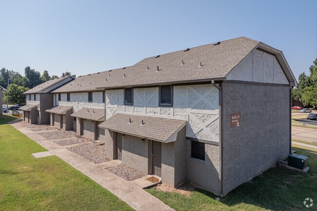
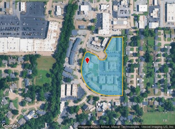
Property Record
301 Hal Muldrow Dr, Norman, OK 73069
NEARBY LISTINGS FOR SALE OR LEASE
Property Detail
301 Hal Muldrow Dr
Oklahoma City, OK
Pearson Est
R0041153
PEARSON ESTATES 1 LOTS 14-18 BLK 1
Multifamilydwelling
Cleveland
X
Oklahoma
40027C0280J
14
2024
4.45 AC
2024
Outer Norman
201000
Oklahoma City
105,221 SF
DEMOGRAPHICS near 301 Hal Muldrow Dr
1 Mile
3 Mile
5 Mile
2024 Total Population
9,853
71,578
123,953
2029 Population
10,239
74,749
130,177
Pop Growth 2024-2029
+ 3.92%
+ 4.43%
+ 5.02%
Average Age
39
37
36
2024 Total Households
4,347
28,437
49,269
HH Growth 2024-2029
+ 4.09%
+ 4.93%
+ 5.28%
Median Household Inc
$43,230
$53,319
$57,300
Avg Household Size
2.20
2.20
2.30
2024 Avg HH Vehicles
2.00
2.00
2.00
Median Home Value
$182,695
$215,067
$218,986
Median Year Built
1970
1980
1988
Nearby Places
Map Layers
Map Styles
 Street
 Aerial
- Restaurants
- Banks
- Shops
- Fitness
- Groceries
PUBLIC TRANSPORTATION
COMMUTER RAIL
Norman Amtrak Station (Heartland Flyer - Amtrak)
DRIVE
WALK
Distance
Norman Amtrak Station (Heartland Flyer - Amtrak)
5 min
1.9 mi
AIRPORT
Will Rogers World
DRIVE
WALK
Distance
Will Rogers World
33 min
21.3 mi
Freight Ports
Tulsa Port Of Catoosa
DRIVE
WALK
Distance
Tulsa Port Of Catoosa
154 min
140.5 mi
SALE & LEASE HISTORY
LISTING DATE
SALE/LEASE

May 23, 2018
For Sale
Nearby Properties
Address
Land Use
TOTAL SIZE
Lot Size
Zoning
Address
Land Use
TOTAL SIZE
Lot Size
Zoning
24.50 AC
Address
Land Use
TOTAL SIZE
Lot Size
Zoning
18,644 SF
2.16 AC
CO
Address
Land Use
TOTAL SIZE
Lot Size
Zoning
44.21 AC
Address
Land Use
TOTAL SIZE
Lot Size
Zoning
3.75 AC
Address
Land Use
TOTAL SIZE
Lot Size
Zoning
Address
Land Use
TOTAL SIZE
Lot Size
Zoning
4.86 AC
Address
Land Use
TOTAL SIZE
Lot Size
Zoning
100,000 SF
208.35 AC
Address
Land Use
TOTAL SIZE
Lot Size
Zoning
191,169 SF
6.30 AC
I2
Address
Land Use
TOTAL SIZE
Lot Size
Zoning
2.57 AC
Address
Land Use
TOTAL SIZE
Lot Size
Zoning
Address
Land Use
TOTAL SIZE
Lot Size
Zoning
Address
Land Use
TOTAL SIZE
Lot Size
Zoning
60,000 SF
4.39 AC
RM
Address
Land Use
TOTAL SIZE
Lot Size
Zoning
17.11 AC
Address
Land Use
TOTAL SIZE
Lot Size
Zoning
0.86 AC
Address
Land Use
TOTAL SIZE
Lot Size
Zoning
Address
Land Use
TOTAL SIZE
Lot Size
Zoning
319,555 SF
6.86 AC
Address
Land Use
TOTAL SIZE
Lot Size
Zoning
Address
Land Use
TOTAL SIZE
Lot Size
Zoning
3.09 AC
Address
Land Use
TOTAL SIZE
Lot Size
Zoning
7.20 AC
Address
Land Use
TOTAL SIZE
Lot Size
Zoning
174,742 SF
26.71 AC
Address
Land Use
TOTAL SIZE
Lot Size
Zoning
0.41 AC
R2
Address
Land Use
TOTAL SIZE
Lot Size
Zoning
5.22 AC
Address
Land Use
TOTAL SIZE
Lot Size
Zoning
16,128 SF
2.83 AC
I1
Address
Land Use
TOTAL SIZE
Lot Size
Zoning
Address
Land Use
TOTAL SIZE
Lot Size
Zoning
32,789 SF
9.50 AC
I1
Address
Land Use
TOTAL SIZE
Lot Size
Zoning
Address
Land Use
TOTAL SIZE
Lot Size
Zoning
24,641 SF
3 AC
Address
Land Use
TOTAL SIZE
Lot Size
Zoning
292,511 SF
6.20 AC
Address
Land Use
TOTAL SIZE
Lot Size
Zoning
102,331 SF
12.46 AC
The World's #1 Commercial Real Estate Marketplace
Connect with us
© 2025 CoStar Group
The information above has been obtained from sources believed reliable. While we do not doubt its accuracy we have not verified it and make no guarantee, warranty or representation about it. It is your responsibility to independently confirm its accuracy and completeness. Any projections, opinions, assumptions, or estimates used are for example only and do not represent the current or future performance of the property. The value of this transaction to you depends on tax and other factors which should be evaluated by your tax, financial, and legal advisors. You and your advisors should conduct a careful, independent investigation of the property to determine to your satisfaction the suitability of the property for your needs.