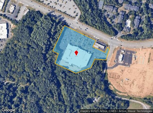
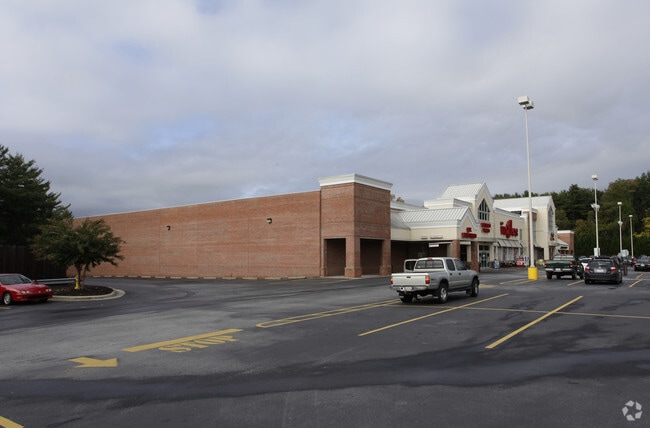
Property Record
301 Long Shoals Rd, Arden, NC 28704

NEARBY LISTINGS FOR SALE OR LEASE
Property Detail
301 Long Shoals Rd
Asheville, NC
Ingles
9644-38-5421-00000
SUBDIV: INGLES BLOCK: LOT: 1 SECTION: PLAT: 0118-0103
Supermarket
Buncombe
X
North Carolina
3700964400J
1
2024
5.74 AC
2025
S Asheville/Royal Pines
002203
Asheville
67,735 SF
DEMOGRAPHICS near 301 Long Shoals Rd
1 Mile
3 Mile
5 Mile
2024 Total Population
3,866
33,450
57,872
2029 Population
4,031
34,828
60,093
Pop Growth 2024-2029
+ 4.27%
+ 4.12%
+ 3.84%
Average Age
43
42
43
2024 Total Households
1,756
15,114
25,317
HH Growth 2024-2029
+ 3.70%
+ 3.54%
+ 3.35%
Median Household Inc
$82,143
$70,541
$73,733
Avg Household Size
2.20
2.20
2.20
2024 Avg HH Vehicles
2.00
2.00
2.00
Median Home Value
$665,028
$379,080
$374,824
Median Year Built
2005
1997
1995
Nearby Places
Map Layers
Map Styles
 Street
 Aerial
- Restaurants
- Banks
- Shops
- Fitness
- Groceries
PUBLIC TRANSPORTATION
AIRPORT
Asheville Regional
DRIVE
WALK
Distance
Asheville Regional
7 min
4.0 mi
Nearby Properties
Address
Land Use
TOTAL SIZE
Lot Size
Zoning
Address
Land Use
TOTAL SIZE
Lot Size
Zoning
1,204,424 SF
100 AC
EMP
Address
Land Use
TOTAL SIZE
Lot Size
Zoning
416,455 SF
135.80 AC
RM16
Address
Land Use
TOTAL SIZE
Lot Size
Zoning
430,117 SF
119.99 AC
COM EXP
Address
Land Use
TOTAL SIZE
Lot Size
Zoning
346,375 SF
58.11 AC
INST
Address
Land Use
TOTAL SIZE
Lot Size
Zoning
118,357 SF
24.67 AC
EMP
Address
Land Use
TOTAL SIZE
Lot Size
Zoning
110,173 SF
28.13 AC
R-2
Address
Land Use
TOTAL SIZE
Lot Size
Zoning
83,129 SF
44.74 AC
EMP
Address
Land Use
TOTAL SIZE
Lot Size
Zoning
89,714 SF
15.86 AC
HB
Address
Land Use
TOTAL SIZE
Lot Size
Zoning
78,745 SF
14.73 AC
HB
Address
Land Use
TOTAL SIZE
Lot Size
Zoning
85,103 SF
11.69 AC
RES EXP
Address
Land Use
TOTAL SIZE
Lot Size
Zoning
66,863 SF
7.48 AC
INST
Address
Land Use
TOTAL SIZE
Lot Size
Zoning
57,836 SF
1.09 AC
UV
Address
Land Use
TOTAL SIZE
Lot Size
Zoning
107,408 SF
21.92 AC
R-3
Address
Land Use
TOTAL SIZE
Lot Size
Zoning
183,020 SF
22.84 AC
RM16
Address
Land Use
TOTAL SIZE
Lot Size
Zoning
77,056 SF
19.45 AC
EMP
Address
Land Use
TOTAL SIZE
Lot Size
Zoning
180,324 SF
54.83 AC
RM16
Address
Land Use
TOTAL SIZE
Lot Size
Zoning
3,161 SF
1,161.20 AC
CR
Address
Land Use
TOTAL SIZE
Lot Size
Zoning
196,645 SF
30.61 AC
RM16
Address
Land Use
TOTAL SIZE
Lot Size
Zoning
198,705 SF
32.46 AC
HB
Address
Land Use
TOTAL SIZE
Lot Size
Zoning
227,740 SF
36.18 AC
INST
Address
Land Use
TOTAL SIZE
Lot Size
Zoning
82,267 SF
14.05 AC
CI
Address
Land Use
TOTAL SIZE
Lot Size
Zoning
218,133 SF
15.39 AC
R-2
Address
Land Use
TOTAL SIZE
Lot Size
Zoning
73,420 SF
10.24 AC
RM16
Address
Land Use
TOTAL SIZE
Lot Size
Zoning
155,715 SF
36.84 AC
RM16
Address
Land Use
TOTAL SIZE
Lot Size
Zoning
80,872 SF
18.84 AC
RM16
Address
Land Use
TOTAL SIZE
Lot Size
Zoning
93,197 SF
6.32 AC
RES EXP
Address
Land Use
TOTAL SIZE
Lot Size
Zoning
71,574 SF
15.85 AC
RM16
Address
Land Use
TOTAL SIZE
Lot Size
Zoning
332,974 SF
8.38 AC
EMP
Address
Land Use
TOTAL SIZE
Lot Size
Zoning
64,868 SF
11.20 AC
HB
Address
Land Use
TOTAL SIZE
Lot Size
Zoning
63,030 SF
5.70 AC
RES EXP
The World's #1 Commercial Real Estate Marketplace
Connect with us
© 2026 CoStar Group
The information above has been obtained from sources believed reliable. While we do not doubt its accuracy we have not verified it and make no guarantee, warranty or representation about it. It is your responsibility to independently confirm its accuracy and completeness. Any projections, opinions, assumptions, or estimates used are for example only and do not represent the current or future performance of the property. The value of this transaction to you depends on tax and other factors which should be evaluated by your tax, financial, and legal advisors. You and your advisors should conduct a careful, independent investigation of the property to determine to your satisfaction the suitability of the property for your needs.