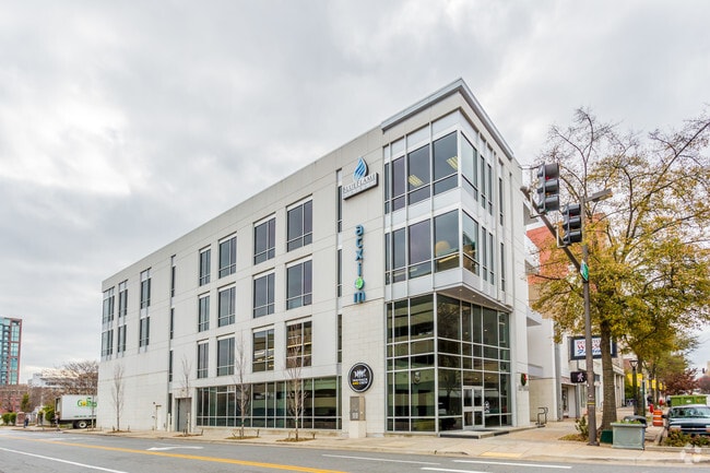
Property Record
301 Main St, Little Rock, AR 72201

Current Lease Availabilities
NEARBY LISTINGS FOR SALE OR LEASE
Property Detail
301 Main St
34L-020-01-015-00
City Of Lr L1
Officebuilding
Pulaski
X
Arkansas
05119C0457G
1
2025
0.16 AC
2025
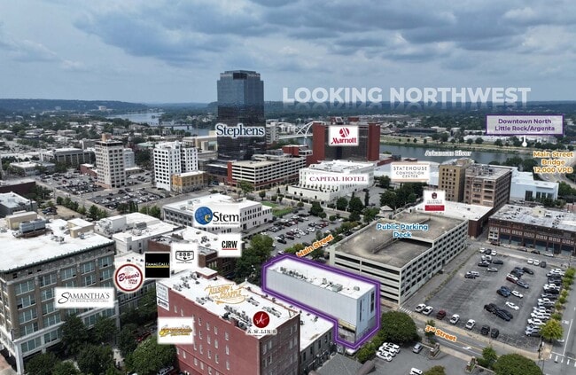
Downtown
004400
Little Rock/N Little Rock
24,309 SF
Little Rock-North Little Rock-Conway, AR
DEMOGRAPHICS near 301 Main St
1 Mile
3 Mile
5 Mile
2024 Total Population
6,070
49,983
120,072
2029 Population
6,191
51,278
121,656
Pop Growth 2024-2029
+ 1.99%
+ 2.59%
+ 1.32%
Average Age
42
40
39
2024 Total Households
3,958
23,805
54,917
HH Growth 2024-2029
+ 1.89%
+ 2.45%
+ 1.36%
Median Household Inc
$49,903
$39,858
$43,864
Avg Household Size
1.50
1.90
2.00
2024 Avg HH Vehicles
1.00
1.00
1.00
Median Home Value
$234,375
$144,899
$150,361
Median Year Built
1971
1961
1966
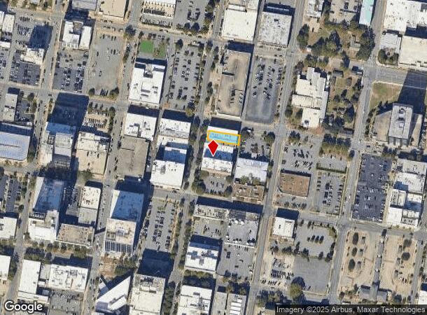
Nearby Places
Map Layers
Map Styles
 Street
 Aerial
- Restaurants
- Banks
- Shops
- Fitness
- Groceries
PUBLIC TRANSPORTATION
TRANSIT/SUBWAY
2Nd St & Scott St (Blue Line Streetcar - Rock Region Metro)
DRIVE
WALK
Distance
2Nd St & Scott St (Blue Line Streetcar - Rock Region Metro)
0 min
3 min
0.2 mi
West Markham & Scott St - Marriott (Blue Line Streetcar - Rock Region Metro)
DRIVE
WALK
Distance
West Markham & Scott St - Marriott (Blue Line Streetcar - Rock Region Metro)
0 min
4 min
0.2 mi
2Nd St & Center St (Blue Line Streetcar - Rock Region Metro)
DRIVE
WALK
Distance
2Nd St & Center St (Blue Line Streetcar - Rock Region Metro)
0 min
4 min
0.2 mi
2Nd St & Rock St (Blue Line Streetcar - Rock Region Metro)
DRIVE
WALK
Distance
2Nd St & Rock St (Blue Line Streetcar - Rock Region Metro)
1 min
5 min
0.3 mi
West Markham St & Spring St (Blue Line Streetcar - Rock Region Metro)
DRIVE
WALK
Distance
West Markham St & Spring St (Blue Line Streetcar - Rock Region Metro)
0 min
6 min
0.3 mi
COMMUTER RAIL
Little Rock Union Station (Texas Eagle - Amtrak)
DRIVE
WALK
Distance
Little Rock Union Station (Texas Eagle - Amtrak)
2 min
1.1 mi
AIRPORT
Bill and Hillary Clinton Ntl/Adams Field
DRIVE
WALK
Distance
Bill and Hillary Clinton Ntl/Adams Field
9 min
4.8 mi
Freight Ports
Port of Shreveport
DRIVE
WALK
Distance
Port of Shreveport
251 min
233.9 mi
Nearby Properties
Address
Land Use
TOTAL SIZE
Lot Size
Zoning
Address
Land Use
TOTAL SIZE
Lot Size
Zoning
1.80 AC
Address
Land Use
TOTAL SIZE
Lot Size
Zoning
4,400,000 SF
27.97 AC
Address
Land Use
TOTAL SIZE
Lot Size
Zoning
0.90 AC
Address
Land Use
TOTAL SIZE
Lot Size
Zoning
0.45 AC
Address
Land Use
TOTAL SIZE
Lot Size
Zoning
802,734 SF
22.99 AC
Address
Land Use
TOTAL SIZE
Lot Size
Zoning
1,000,000 SF
9.38 AC
Address
Land Use
TOTAL SIZE
Lot Size
Zoning
333,096 SF
11.62 AC
Address
Land Use
TOTAL SIZE
Lot Size
Zoning
475,613 SF
10.14 AC
Address
Land Use
TOTAL SIZE
Lot Size
Zoning
237,144 SF
1.26 AC
Address
Land Use
TOTAL SIZE
Lot Size
Zoning
180,616 SF
0.91 AC
Address
Land Use
TOTAL SIZE
Lot Size
Zoning
12,562 SF
2.26 AC
Address
Land Use
TOTAL SIZE
Lot Size
Zoning
603,434 SF
10.21 AC
Address
Land Use
TOTAL SIZE
Lot Size
Zoning
412,597 SF
Address
Land Use
TOTAL SIZE
Lot Size
Zoning
297,814 SF
86.09 AC
Address
Land Use
TOTAL SIZE
Lot Size
Zoning
22,017 SF
2.06 AC
Address
Land Use
TOTAL SIZE
Lot Size
Zoning
305,882 SF
7.82 AC
Address
Land Use
TOTAL SIZE
Lot Size
Zoning
761,810 SF
75.61 AC
Address
Land Use
TOTAL SIZE
Lot Size
Zoning
576 SF
62.63 AC
Address
Land Use
TOTAL SIZE
Lot Size
Zoning
2,636 SF
0.67 AC
Address
Land Use
TOTAL SIZE
Lot Size
Zoning
267,152 SF
Address
Land Use
TOTAL SIZE
Lot Size
Zoning
137,538 SF
31.58 AC
Address
Land Use
TOTAL SIZE
Lot Size
Zoning
260,000 SF
5.80 AC
Address
Land Use
TOTAL SIZE
Lot Size
Zoning
143,553 SF
12.76 AC
Address
Land Use
TOTAL SIZE
Lot Size
Zoning
130,742 SF
15.71 AC
Address
Land Use
TOTAL SIZE
Lot Size
Zoning
95,719 SF
32.76 AC
Address
Land Use
TOTAL SIZE
Lot Size
Zoning
346,974 SF
Address
Land Use
TOTAL SIZE
Lot Size
Zoning
138,352 SF
2.95 AC
Address
Land Use
TOTAL SIZE
Lot Size
Zoning
61,225 SF
5.66 AC
Address
Land Use
TOTAL SIZE
Lot Size
Zoning
269,624 SF
3.40 AC
Address
Land Use
TOTAL SIZE
Lot Size
Zoning
361,910 SF
The World's #1 Commercial Real Estate Marketplace
Connect with us
© 2025 CoStar Group
The information above has been obtained from sources believed reliable. While we do not doubt its accuracy we have not verified it and make no guarantee, warranty or representation about it. It is your responsibility to independently confirm its accuracy and completeness. Any projections, opinions, assumptions, or estimates used are for example only and do not represent the current or future performance of the property. The value of this transaction to you depends on tax and other factors which should be evaluated by your tax, financial, and legal advisors. You and your advisors should conduct a careful, independent investigation of the property to determine to your satisfaction the suitability of the property for your needs.