Property Record
301 N 6Th St, Saint Clair, MI 48079


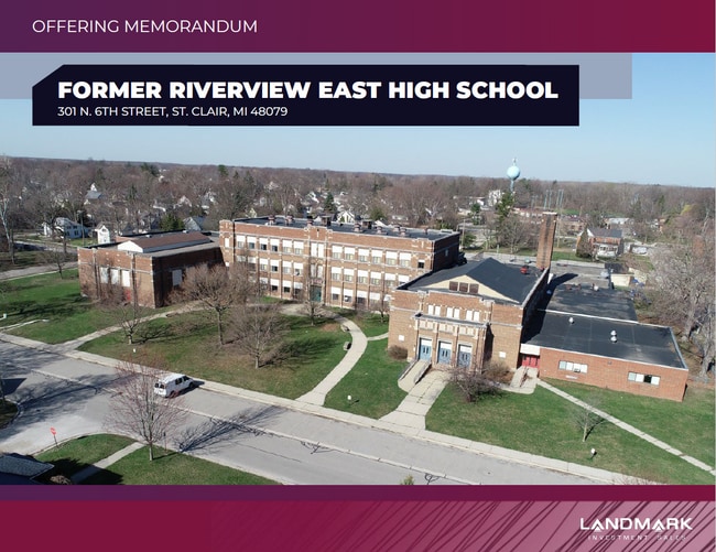
This Property Is For Sale
Property Detail
301 N 6Th St
07-049-0238-000
PIECE OF LAND BOUNDED N BY ORCHARD ST, E BY 6TH ST, S BY THORNAPPLE ST, W BY 8TH ST BLKS 21, 22, 41 & 42 ALSO E 15' OF 8TH ST VAC & N 69' OF THAT PART OF UNOPENED ST ADJ & LYING S OF BLK 16 MAP OF ST CLAIR
Commercialnec
Saint Clair
R-1A MED D
Michigan
B and X Area of moderate flood hazard, usually the area between the limits of the 100-year and 500-year floods.
4.53 AC
2025
St Clair & Lapeer Counties
2025
Detroit
642000
Detroit-Warren-Dearborn, MI
NEARBY LISTINGS FOR SALE OR LEASE
-
-
View all Saint Clair listings for sale on LoopNet.com
DEMOGRAPHICS near 301 N 6Th St
1 mile
3 mile
5 mile
2025 Total Population
5,111
11,053
16,032
2030 Population
5,128
11,148
16,119
Pop Growth 2025-2030
+ 0.33%
+ 0.86%
+ 0.54%
Average Age
43
45
45
2025 Total Households
2,220
4,681
6,860
HH Growth 2025-2030
+ 0.32%
+ 0.79%
+ 0.52%
Median Household Inc
$68,627
$71,221
$70,333
Avg Household Size
2.20
2.30
2.30
2025 Avg HH Vehicles
2.00
2.00
2.00
Median Home Value
$245,209
$270,574
$271,660
Median Year Built
1960
1975
1978
Nearby Places
Map Layers
Map Styles
 Street
 Aerial
Layers
 Traffic
 Biking
Places
Listings with unknown addresses are not visible on the map
- Restaurants
- Banks
- Shops
- Fitness
- Groceries
Nearby Properties
Address
Land Use
TOTAL SIZE
Lot Size
Zoning
Address
Land Use
TOTAL SIZE
Lot Size
Zoning
720,000 SF
Address
Land Use
TOTAL SIZE
Lot Size
Zoning
369,800 SF
Address
Land Use
TOTAL SIZE
Lot Size
Zoning
98,736 SF
8.49 AC
RM
Address
Land Use
TOTAL SIZE
Lot Size
Zoning
112,914 SF
9.89 AC
R-3 MLTPLE
Address
Land Use
TOTAL SIZE
Lot Size
Zoning
84,198 SF
8.95 AC
C-2 GENERA
Address
Land Use
TOTAL SIZE
Lot Size
Zoning
46,800 SF
Address
Land Use
TOTAL SIZE
Lot Size
Zoning
133,345 SF
11.69 AC
M-1 LIGHT
Address
Land Use
TOTAL SIZE
Lot Size
Zoning
184,348 SF
17.77 AC
I-1
Address
Land Use
TOTAL SIZE
Lot Size
Zoning
579,846 SF
8.21 AC
M-2 HEAVY
Address
Land Use
TOTAL SIZE
Lot Size
Zoning
137,000 SF
11.14 AC
M-1 LIGHT
Address
Land Use
TOTAL SIZE
Lot Size
Zoning
65,924 SF
6.36 AC
MC
Address
Land Use
TOTAL SIZE
Lot Size
Zoning
112,486 SF
11.91 AC
M-1 LIGHT
Address
Land Use
TOTAL SIZE
Lot Size
Zoning
53,291 SF
Address
Land Use
TOTAL SIZE
Lot Size
Zoning
30.80 AC
R-3 MLTPLE
Address
Land Use
TOTAL SIZE
Lot Size
Zoning
39,000 SF
8.46 AC
B-2
Address
Land Use
TOTAL SIZE
Lot Size
Zoning
9.60 AC
R-1 LOW DE
Address
Land Use
TOTAL SIZE
Lot Size
Zoning
54,096 SF
6.10 AC
R-1A MED D
Address
Land Use
TOTAL SIZE
Lot Size
Zoning
24,261 SF
4.42 AC
C-2 GENERA
Address
Land Use
TOTAL SIZE
Lot Size
Zoning
24,727 SF
0.90 AC
C-1 LOCAL
Address
Land Use
TOTAL SIZE
Lot Size
Zoning
11,565 SF
4.43 AC
C-2 GENERA
Address
Land Use
TOTAL SIZE
Lot Size
Zoning
66,521 SF
5.78 AC
M-1 LIGHT
Address
Land Use
TOTAL SIZE
Lot Size
Zoning
34,726 SF
6.33 AC
R-3 MLTPLE
Address
Land Use
TOTAL SIZE
Lot Size
Zoning
17,417 SF
1.27 AC
B-2
Address
Land Use
TOTAL SIZE
Lot Size
Zoning
91.42 AC
M-1 LIGHT
Address
Land Use
TOTAL SIZE
Lot Size
Zoning
12,032 SF
3.31 AC
MC
Address
Land Use
TOTAL SIZE
Lot Size
Zoning
12,952 SF
131.83 AC
RM
Address
Land Use
TOTAL SIZE
Lot Size
Zoning
7,380 SF
1.82 AC
C-2 GENERA
Address
Land Use
TOTAL SIZE
Lot Size
Zoning
Address
Land Use
TOTAL SIZE
Lot Size
Zoning
74,400 SF
7.52 AC
M-1 LIGHT
Address
Land Use
TOTAL SIZE
Lot Size
Zoning
41,160 SF
M-1 LIGHT
The World's #1 Commercial Real Estate Marketplace
Connect with us
© 2026 CoStar Group
The information above has been obtained from sources believed reliable. While we do not doubt its accuracy we have not verified it and make no guarantee, warranty or representation about it. It is your responsibility to independently confirm its accuracy and completeness. Any projections, opinions, assumptions, or estimates used are for example only and do not represent the current or future performance of the property. The value of this transaction to you depends on tax and other factors which should be evaluated by your tax, financial, and legal advisors. You and your advisors should conduct a careful, independent investigation of the property to determine to your satisfaction the suitability of the property for your needs.