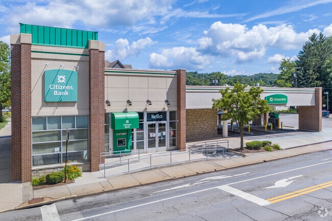
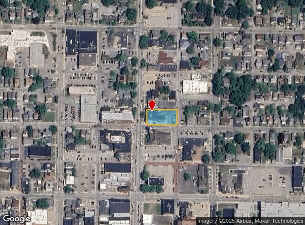
Property Record
301 N Main St, Butler, PA 16001


NEARBY LISTINGS FOR SALE OR LEASE
Property Detail
301 N Main St
564-9-47-0000
0.36 AC BANK
Commercialnec
Butler
X
Pennsylvania
42019C0407D
0.36 AC
2025
Butler County
2025
Pittsburgh
902400
Pittsburgh, PA
DEMOGRAPHICS near 301 N Main St
1 Mile
3 Mile
5 Mile
2024 Total Population
14,209
31,592
47,314
2029 Population
14,679
32,520
48,559
Pop Growth 2024-2029
+ 3.31%
+ 2.94%
+ 2.63%
Average Age
40
43
44
2024 Total Households
6,434
14,089
20,769
HH Growth 2024-2029
+ 3.34%
+ 2.99%
+ 2.72%
Median Household Inc
$36,836
$50,803
$57,354
Avg Household Size
2.10
2.10
2.20
2024 Avg HH Vehicles
1.00
2.00
2.00
Median Home Value
$87,541
$147,001
$169,556
Median Year Built
1947
1955
1960
Nearby Places
Map Layers
Map Styles
 Street
 Aerial
- Restaurants
- Banks
- Shops
- Fitness
- Groceries
PUBLIC TRANSPORTATION
AIRPORT
Pittsburgh International
DRIVE
WALK
Distance
Pittsburgh International
69 min
41.6 mi
SALE & LEASE HISTORY
LISTING DATE
SALE/LEASE

Jan 09, 2020
For Sale
Nearby Properties
Address
Land Use
TOTAL SIZE
Lot Size
Zoning
Address
Land Use
TOTAL SIZE
Lot Size
Zoning
75.96 AC
Address
Land Use
TOTAL SIZE
Lot Size
Zoning
19.50 AC
Address
Land Use
TOTAL SIZE
Lot Size
Zoning
95.97 AC
Address
Land Use
TOTAL SIZE
Lot Size
Zoning
297.39 AC
Address
Land Use
TOTAL SIZE
Lot Size
Zoning
13.62 AC
Address
Land Use
TOTAL SIZE
Lot Size
Zoning
12.55 AC
Address
Land Use
TOTAL SIZE
Lot Size
Zoning
1.04 AC
Address
Land Use
TOTAL SIZE
Lot Size
Zoning
0.94 AC
Address
Land Use
TOTAL SIZE
Lot Size
Zoning
1,255.20 AC
Address
Land Use
TOTAL SIZE
Lot Size
Zoning
7.80 AC
Address
Land Use
TOTAL SIZE
Lot Size
Zoning
21.31 AC
Address
Land Use
TOTAL SIZE
Lot Size
Zoning
Address
Land Use
TOTAL SIZE
Lot Size
Zoning
1.24 AC
Address
Land Use
TOTAL SIZE
Lot Size
Zoning
0.77 AC
Address
Land Use
TOTAL SIZE
Lot Size
Zoning
5.89 AC
Address
Land Use
TOTAL SIZE
Lot Size
Zoning
3.72 AC
Address
Land Use
TOTAL SIZE
Lot Size
Zoning
8.47 AC
Address
Land Use
TOTAL SIZE
Lot Size
Zoning
16.18 AC
Address
Land Use
TOTAL SIZE
Lot Size
Zoning
2.78 AC
Address
Land Use
TOTAL SIZE
Lot Size
Zoning
1.12 AC
Address
Land Use
TOTAL SIZE
Lot Size
Zoning
8.31 AC
Address
Land Use
TOTAL SIZE
Lot Size
Zoning
0.42 AC
Address
Land Use
TOTAL SIZE
Lot Size
Zoning
0.77 AC
Address
Land Use
TOTAL SIZE
Lot Size
Zoning
0.57 AC
Address
Land Use
TOTAL SIZE
Lot Size
Zoning
4.61 AC
Address
Land Use
TOTAL SIZE
Lot Size
Zoning
2.50 AC
Address
Land Use
TOTAL SIZE
Lot Size
Zoning
10.82 AC
Address
Land Use
TOTAL SIZE
Lot Size
Zoning
15.65 AC
Address
Land Use
TOTAL SIZE
Lot Size
Zoning
12.60 AC
Address
Land Use
TOTAL SIZE
Lot Size
Zoning
0.76 AC
The World's #1 Commercial Real Estate Marketplace
Connect with us
© 2025 CoStar Group
The information above has been obtained from sources believed reliable. While we do not doubt its accuracy we have not verified it and make no guarantee, warranty or representation about it. It is your responsibility to independently confirm its accuracy and completeness. Any projections, opinions, assumptions, or estimates used are for example only and do not represent the current or future performance of the property. The value of this transaction to you depends on tax and other factors which should be evaluated by your tax, financial, and legal advisors. You and your advisors should conduct a careful, independent investigation of the property to determine to your satisfaction the suitability of the property for your needs.