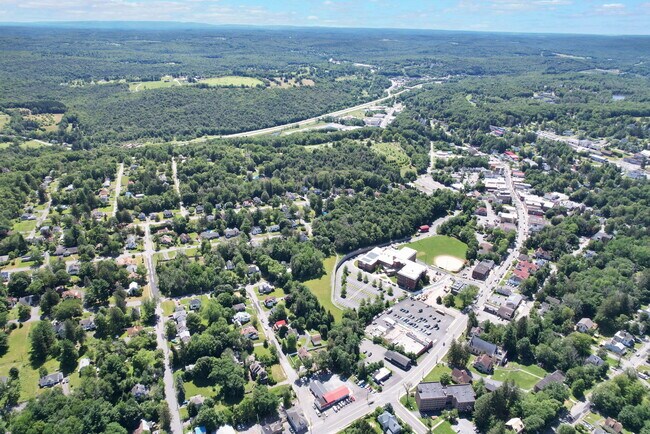
Property Record
301 N Main St, Liberty, NY 12754
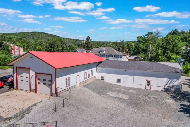
This Property Is For Sale
NEARBY LISTINGS FOR SALE OR LEASE
-
-
View all Liberty listings for sale on LoopNet.com
Property Detail
301 N Main St
Autorepair
Sullivan
A
New York
36105C0311F
2.000
2025
0.33 AC
2024
Hudson Valley Area
950500
Other Market Areas
5,020 SF
3601-104-0-0010-001-000
DEMOGRAPHICS near 301 N Main St
1 Mile
3 Mile
5 Mile
2024 Total Population
4,902
7,770
11,588
2029 Population
5,213
8,249
12,315
Pop Growth 2024-2029
+ 6.34%
+ 6.16%
+ 6.27%
Average Age
39
40
41
2024 Total Households
1,821
2,960
4,447
HH Growth 2024-2029
+ 6.64%
+ 6.55%
+ 6.66%
Median Household Inc
$66,258
$61,990
$60,101
Avg Household Size
2.60
2.50
2.40
2024 Avg HH Vehicles
1.00
1.00
2.00
Median Home Value
$202,874
$226,163
$257,918
Median Year Built
1956
1960
1968
Nearby Places
- Restaurants
- Banks
- Shops
- Fitness
- Groceries
Nearby Properties
Address
Land Use
TOTAL SIZE
Lot Size
Zoning
Address
Land Use
TOTAL SIZE
Lot Size
Zoning
98,138 SF
47.80 AC
C
Address
Land Use
TOTAL SIZE
Lot Size
Zoning
58,488 SF
50 AC
C
Address
Land Use
TOTAL SIZE
Lot Size
Zoning
16,872 SF
67 AC
C
Address
Land Use
TOTAL SIZE
Lot Size
Zoning
127,937 SF
12.41 AC
C
Address
Land Use
TOTAL SIZE
Lot Size
Zoning
6,832 SF
31.50 AC
RD
Address
Land Use
TOTAL SIZE
Lot Size
Zoning
108,721 SF
3.93 AC
M
Address
Land Use
TOTAL SIZE
Lot Size
Zoning
21,288 SF
43.34 AC
RD2
Address
Land Use
TOTAL SIZE
Lot Size
Zoning
58,675 SF
6.46 AC
C
Address
Land Use
TOTAL SIZE
Lot Size
Zoning
1,042,540 SF
14.62 AC
C
Address
Land Use
TOTAL SIZE
Lot Size
Zoning
21,600 SF
7.10 AC
SC
Address
Land Use
TOTAL SIZE
Lot Size
Zoning
8,080 SF
7.07 AC
C
Address
Land Use
TOTAL SIZE
Lot Size
Zoning
20,777 SF
118.90 AC
RD2
Address
Land Use
TOTAL SIZE
Lot Size
Zoning
3,196 SF
80.90 AC
RD2
Address
Land Use
TOTAL SIZE
Lot Size
Zoning
14,658 SF
5.67 AC
M
Address
Land Use
TOTAL SIZE
Lot Size
Zoning
4,230 SF
59.74 AC
C
Address
Land Use
TOTAL SIZE
Lot Size
Zoning
26,884 SF
100.72 AC
RD2
Address
Land Use
TOTAL SIZE
Lot Size
Zoning
5,996 SF
35.47 AC
C
Address
Land Use
TOTAL SIZE
Lot Size
Zoning
65,628 SF
2.70 AC
C
Address
Land Use
TOTAL SIZE
Lot Size
Zoning
15,401 SF
62.56 AC
SC
Address
Land Use
TOTAL SIZE
Lot Size
Zoning
20,816 SF
1.90 AC
C
Address
Land Use
TOTAL SIZE
Lot Size
Zoning
16,176 SF
20.16 AC
RD
Address
Land Use
TOTAL SIZE
Lot Size
Zoning
23,768 SF
2.24 AC
C
Address
Land Use
TOTAL SIZE
Lot Size
Zoning
6,048 SF
105.58 AC
RD2
Address
Land Use
TOTAL SIZE
Lot Size
Zoning
9,922 SF
62.53 AC
IC
Address
Land Use
TOTAL SIZE
Lot Size
Zoning
5,460 SF
65 AC
RD
Address
Land Use
TOTAL SIZE
Lot Size
Zoning
9,543 SF
67.02 AC
IC
Address
Land Use
TOTAL SIZE
Lot Size
Zoning
2,131 SF
93.10 AC
RD2
Address
Land Use
TOTAL SIZE
Lot Size
Zoning
18,472 SF
1.33 AC
C
Address
Land Use
TOTAL SIZE
Lot Size
Zoning
42,371 SF
1.20 AC
C
Address
Land Use
TOTAL SIZE
Lot Size
Zoning
15,068 SF
8.41 AC
C
The World's #1 Commercial Real Estate Marketplace
Connect with us
© 2025 CoStar Group
The information above has been obtained from sources believed reliable. While we do not doubt its accuracy we have not verified it and make no guarantee, warranty or representation about it. It is your responsibility to independently confirm its accuracy and completeness. Any projections, opinions, assumptions, or estimates used are for example only and do not represent the current or future performance of the property. The value of this transaction to you depends on tax and other factors which should be evaluated by your tax, financial, and legal advisors. You and your advisors should conduct a careful, independent investigation of the property to determine to your satisfaction the suitability of the property for your needs.