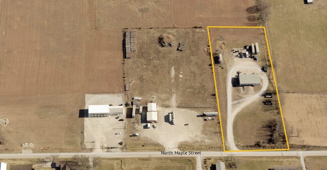
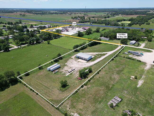
Property Record
301 N Maple St, Cherryvale, KS 67335

Current Lease Availabilities
Property Detail
301 N Maple St
103-08-0-40-04-001.01-0
EXT TO CITY LIMITS 8-32-17, S08, T32, R17, ACRES 3.4, BEG 1065' S NW COR NW4 SE4 E 660' S 225' W 660' N TO POB; LOT WIDTH:
Warehouse
Montgomery
B and X Area of moderate flood hazard, usually the area between the limits of the 100-year and 500-year floods.
Kansas
2024
3.40 AC
2025
Kansas Area
950200
Other Market Areas
3,000 SF
NEARBY LISTINGS FOR SALE OR LEASE
DEMOGRAPHICS near 301 N Maple St
1 mile
3 mile
5 mile
2025 Total Population
1,460
2,813
3,109
2030 Population
1,470
2,815
3,089
Pop Growth 2025-2030
+ 0.68%
+ 0.07%
(0.64%)
Average Age
41
41
41
2025 Total Households
584
1,124
1,237
HH Growth 2025-2030
+ 0.51%
(0.09%)
(0.73%)
Median Household Inc
$49,196
$49,905
$50,621
Avg Household Size
2.50
2.50
2.50
2025 Avg HH Vehicles
2.00
2.00
2.00
Median Home Value
$85,655
$88,925
$93,312
Median Year Built
1952
1953
1955
Nearby Places
Map Layers
Map Styles
 Street
 Aerial
Layers
 Traffic
 Biking
Places
Listings with unknown addresses are not visible on the map
- Restaurants
- Banks
- Shops
- Fitness
- Groceries
Nearby Properties
Address
Land Use
TOTAL SIZE
Lot Size
Zoning
Address
Land Use
TOTAL SIZE
Lot Size
Zoning
82,733 SF
5.40 AC
Address
Land Use
TOTAL SIZE
Lot Size
Zoning
50,341 SF
1.20 AC
Address
Land Use
TOTAL SIZE
Lot Size
Zoning
7,156 SF
1.70 AC
Address
Land Use
TOTAL SIZE
Lot Size
Zoning
11,700 SF
1 AC
Address
Land Use
TOTAL SIZE
Lot Size
Zoning
9,410 SF
0.40 AC
Address
Land Use
TOTAL SIZE
Lot Size
Zoning
13,572 SF
1.82 AC
Address
Land Use
TOTAL SIZE
Lot Size
Zoning
12,390 SF
0.98 AC
Address
Land Use
TOTAL SIZE
Lot Size
Zoning
12,030 SF
1.50 AC
Address
Land Use
TOTAL SIZE
Lot Size
Zoning
1,500 SF
0.44 AC
Address
Land Use
TOTAL SIZE
Lot Size
Zoning
8,845 SF
0.48 AC
Address
Land Use
TOTAL SIZE
Lot Size
Zoning
16,650 SF
2 AC
336
Address
Land Use
TOTAL SIZE
Lot Size
Zoning
2,464 SF
0.65 AC
Address
Land Use
TOTAL SIZE
Lot Size
Zoning
8,497 SF
0.55 AC
Address
Land Use
TOTAL SIZE
Lot Size
Zoning
58,025 SF
5.20 AC
Address
Land Use
TOTAL SIZE
Lot Size
Zoning
8,267 SF
0.42 AC
Address
Land Use
TOTAL SIZE
Lot Size
Zoning
890 SF
1.68 AC
Address
Land Use
TOTAL SIZE
Lot Size
Zoning
32,675 SF
5.70 AC
Address
Land Use
TOTAL SIZE
Lot Size
Zoning
2,220 SF
0.33 AC
Address
Land Use
TOTAL SIZE
Lot Size
Zoning
4,160 SF
0.33 AC
Address
Land Use
TOTAL SIZE
Lot Size
Zoning
3,280 SF
0.39 AC
Address
Land Use
TOTAL SIZE
Lot Size
Zoning
0.41 AC
Address
Land Use
TOTAL SIZE
Lot Size
Zoning
5,000 SF
1 AC
Address
Land Use
TOTAL SIZE
Lot Size
Zoning
12.17 AC
Address
Land Use
TOTAL SIZE
Lot Size
Zoning
2,062 SF
0.33 AC
Address
Land Use
TOTAL SIZE
Lot Size
Zoning
4,080 SF
1.69 AC
Address
Land Use
TOTAL SIZE
Lot Size
Zoning
16,509 SF
0.64 AC
Address
Land Use
TOTAL SIZE
Lot Size
Zoning
4,661 SF
5.93 AC
Address
Land Use
TOTAL SIZE
Lot Size
Zoning
3,432 SF
0.27 AC
Address
Land Use
TOTAL SIZE
Lot Size
Zoning
9,200 SF
0.13 AC
Address
Land Use
TOTAL SIZE
Lot Size
Zoning
3,499 SF
0.58 AC
The World's #1 Commercial Real Estate Marketplace
Connect with us
© 2026 CoStar Group
The information above has been obtained from sources believed reliable. While we do not doubt its accuracy we have not verified it and make no guarantee, warranty or representation about it. It is your responsibility to independently confirm its accuracy and completeness. Any projections, opinions, assumptions, or estimates used are for example only and do not represent the current or future performance of the property. The value of this transaction to you depends on tax and other factors which should be evaluated by your tax, financial, and legal advisors. You and your advisors should conduct a careful, independent investigation of the property to determine to your satisfaction the suitability of the property for your needs.