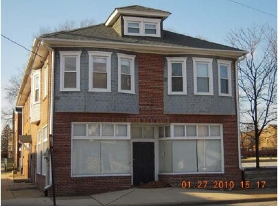
Property Record
301 N Union St, Wilmington, DE 19805
NEARBY LISTINGS FOR SALE OR LEASE
Property Detail
301 N Union St
26-026.40-008
Wilmington
Retailwithmorethanonenonretailuse
New Castle
X
Delaware
10003C0152L
3
2024
0.05 AC
2024
Wilmington CBD
002400
Philadelphia
4,260 SF
Philadelphia-Camden-Wilmington, PA-NJ-DE-MD
DEMOGRAPHICS near 301 N Union St
1 Mile
3 Mile
5 Mile
2024 Total Population
34,952
115,916
194,048
2029 Population
35,716
118,444
197,713
Pop Growth 2024-2029
+ 2.19%
+ 2.18%
+ 1.89%
Average Age
39
39
41
2024 Total Households
15,041
48,368
79,289
HH Growth 2024-2029
+ 2.16%
+ 2.26%
+ 1.95%
Median Household Inc
$51,721
$54,625
$61,881
Avg Household Size
2.20
2.30
2.30
2024 Avg HH Vehicles
1.00
1.00
2.00
Median Home Value
$223,279
$225,016
$255,589
Median Year Built
1947
1951
1956
Nearby Places
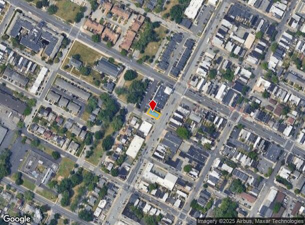
Map Layers
Map Styles
 Street
 Aerial
- Restaurants
- Banks
- Shops
- Fitness
- Groceries
PUBLIC TRANSPORTATION
AIRPORT
Philadelphia International
DRIVE
WALK
Distance
Philadelphia International
32 min
21.6 mi
Nearby Properties
Address
Land Use
TOTAL SIZE
Lot Size
Zoning
Address
Land Use
TOTAL SIZE
Lot Size
Zoning
1,924,803 SF
128.49 AC
OR
Address
Land Use
TOTAL SIZE
Lot Size
Zoning
819,930 SF
78.51 AC
HI
Address
Land Use
TOTAL SIZE
Lot Size
Zoning
45,956 SF
1.05 AC
26C-4
Address
Land Use
TOTAL SIZE
Lot Size
Zoning
202,328 SF
10.98 AC
26R5-C
Address
Land Use
TOTAL SIZE
Lot Size
Zoning
679,619 SF
5.91 AC
26R-3
Address
Land Use
TOTAL SIZE
Lot Size
Zoning
347,001 SF
1.06 AC
26C-4
Address
Land Use
TOTAL SIZE
Lot Size
Zoning
191,280 SF
2.05 AC
26R-3
Address
Land Use
TOTAL SIZE
Lot Size
Zoning
291,946 SF
21.27 AC
26R-2
Address
Land Use
TOTAL SIZE
Lot Size
Zoning
20,000 SF
1.26 AC
26C-4
Address
Land Use
TOTAL SIZE
Lot Size
Zoning
593,288 SF
20.38 AC
OR
Address
Land Use
TOTAL SIZE
Lot Size
Zoning
145,000 SF
0.97 AC
26C-4
Address
Land Use
TOTAL SIZE
Lot Size
Zoning
234,457 SF
18.18 AC
26R-3
Address
Land Use
TOTAL SIZE
Lot Size
Zoning
7,840 SF
3.82 AC
26C-4
Address
Land Use
TOTAL SIZE
Lot Size
Zoning
356,859 SF
55.73 AC
OR
Address
Land Use
TOTAL SIZE
Lot Size
Zoning
38,140 SF
1.15 AC
26C-4
Address
Land Use
TOTAL SIZE
Lot Size
Zoning
43,325 SF
2.69 AC
26C-4
Address
Land Use
TOTAL SIZE
Lot Size
Zoning
406,158 SF
1.29 AC
26C-4
Address
Land Use
TOTAL SIZE
Lot Size
Zoning
332,844 SF
2.15 AC
26C-4
Address
Land Use
TOTAL SIZE
Lot Size
Zoning
596,916 SF
5.97 AC
OR
Address
Land Use
TOTAL SIZE
Lot Size
Zoning
696,387 SF
58.21 AC
OR
Address
Land Use
TOTAL SIZE
Lot Size
Zoning
371,733 SF
10.37 AC
OR
Address
Land Use
TOTAL SIZE
Lot Size
Zoning
410,310 SF
1.27 AC
26R-3
Address
Land Use
TOTAL SIZE
Lot Size
Zoning
107,072 SF
0.76 AC
26C-2
Address
Land Use
TOTAL SIZE
Lot Size
Zoning
80,500 SF
97.08 AC
S
Address
Land Use
TOTAL SIZE
Lot Size
Zoning
301,712 SF
0.92 AC
26C-4
Address
Land Use
TOTAL SIZE
Lot Size
Zoning
472,000 SF
1.05 AC
26C-4
Address
Land Use
TOTAL SIZE
Lot Size
Zoning
2,864 SF
1.02 AC
26C-4
Address
Land Use
TOTAL SIZE
Lot Size
Zoning
96,252 SF
1.50 AC
26R-2
Address
Land Use
TOTAL SIZE
Lot Size
Zoning
871,571 SF
59.53 AC
OR
Address
Land Use
TOTAL SIZE
Lot Size
Zoning
266,847 SF
26C-4
The World's #1 Commercial Real Estate Marketplace
Connect with us
© 2025 CoStar Group
The information above has been obtained from sources believed reliable. While we do not doubt its accuracy we have not verified it and make no guarantee, warranty or representation about it. It is your responsibility to independently confirm its accuracy and completeness. Any projections, opinions, assumptions, or estimates used are for example only and do not represent the current or future performance of the property. The value of this transaction to you depends on tax and other factors which should be evaluated by your tax, financial, and legal advisors. You and your advisors should conduct a careful, independent investigation of the property to determine to your satisfaction the suitability of the property for your needs.