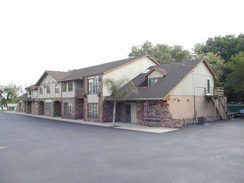
Property Record
301 N White St, Frankfort, IL 60423


Current Lease Availabilities
NEARBY LISTINGS FOR SALE OR LEASE
Property Detail
301 N White St
Chicago-Naperville-Elgin, IL-IN-WI
1St Area -Commercial
19-09-22-300-014
THT PRT OF LOT 2 IN THE SUB OF PRT OF THE SW1/4 OF SEC.22, T35N-R12E. DAF: COMM 35 RODS N OF THE SW COR OF SD LOT 2, BEING IN
Commercialnec
Will
X
Illinois
17197C0213G
2
2024
1 AC
2024
Joliet/Central Will
883504
Chicago
13,156 SF
DEMOGRAPHICS near 301 N White St
1 Mile
3 Mile
5 Mile
2024 Total Population
6,015
45,951
102,646
2029 Population
6,039
45,998
101,972
Pop Growth 2024-2029
+ 0.40%
+ 0.10%
(0.66%)
Average Age
46
41
42
2024 Total Households
2,266
15,799
36,317
HH Growth 2024-2029
+ 0.40%
+ 0.01%
(0.88%)
Median Household Inc
$118,852
$122,710
$115,865
Avg Household Size
2.60
2.90
2.80
2024 Avg HH Vehicles
2.00
2.00
2.00
Median Home Value
$381,610
$359,919
$337,877
Median Year Built
1991
1994
1995
Nearby Places
Map Layers
Map Styles
 Street
 Aerial
- Restaurants
- Banks
- Shops
- Fitness
- Groceries
PUBLIC TRANSPORTATION
COMMUTER RAIL
DRIVE
WALK
Distance
8 min
3.5 mi
Mokena/Front Street Station (Rock Island District Line - Northeast Illinois Regional Commuter Railroad (Metra))
DRIVE
WALK
Distance
Mokena/Front Street Station (Rock Island District Line - Northeast Illinois Regional Commuter Railroad (Metra))
9 min
4.4 mi
AIRPORT
Chicago Midway International
DRIVE
WALK
Distance
Chicago Midway International
40 min
25.1 mi
Chicago O'Hare International
DRIVE
WALK
Distance
Chicago O'Hare International
60 min
35.6 mi
Nearby Properties
Address
Land Use
TOTAL SIZE
Lot Size
Zoning
Address
Land Use
TOTAL SIZE
Lot Size
Zoning
11.40 AC
Address
Land Use
TOTAL SIZE
Lot Size
Zoning
570,796 SF
39.64 AC
Address
Land Use
TOTAL SIZE
Lot Size
Zoning
17.19 AC
Address
Land Use
TOTAL SIZE
Lot Size
Zoning
103,663 SF
13.06 AC
Address
Land Use
TOTAL SIZE
Lot Size
Zoning
304,608 SF
19.51 AC
Address
Land Use
TOTAL SIZE
Lot Size
Zoning
209,485 SF
9.79 AC
Address
Land Use
TOTAL SIZE
Lot Size
Zoning
216,900 SF
10.11 AC
Address
Land Use
TOTAL SIZE
Lot Size
Zoning
23.67 AC
Address
Land Use
TOTAL SIZE
Lot Size
Zoning
3.73 AC
Address
Land Use
TOTAL SIZE
Lot Size
Zoning
77,290 SF
10.23 AC
Address
Land Use
TOTAL SIZE
Lot Size
Zoning
113,474 SF
19.83 AC
Address
Land Use
TOTAL SIZE
Lot Size
Zoning
85,037 SF
8.21 AC
Address
Land Use
TOTAL SIZE
Lot Size
Zoning
106,359 SF
8.25 AC
Address
Land Use
TOTAL SIZE
Lot Size
Zoning
126,480 SF
10.58 AC
Address
Land Use
TOTAL SIZE
Lot Size
Zoning
26,240 SF
2.89 AC
Address
Land Use
TOTAL SIZE
Lot Size
Zoning
97,318 SF
9.80 AC
Address
Land Use
TOTAL SIZE
Lot Size
Zoning
125,016 SF
6.63 AC
Address
Land Use
TOTAL SIZE
Lot Size
Zoning
4.62 AC
Address
Land Use
TOTAL SIZE
Lot Size
Zoning
4.09 AC
Address
Land Use
TOTAL SIZE
Lot Size
Zoning
Address
Land Use
TOTAL SIZE
Lot Size
Zoning
46,151 SF
4.40 AC
Address
Land Use
TOTAL SIZE
Lot Size
Zoning
50,040 SF
1.81 AC
Address
Land Use
TOTAL SIZE
Lot Size
Zoning
2.06 AC
Address
Land Use
TOTAL SIZE
Lot Size
Zoning
107,631 SF
6.82 AC
Address
Land Use
TOTAL SIZE
Lot Size
Zoning
28,324 SF
3.55 AC
Address
Land Use
TOTAL SIZE
Lot Size
Zoning
18,824 SF
9.56 AC
Address
Land Use
TOTAL SIZE
Lot Size
Zoning
Address
Land Use
TOTAL SIZE
Lot Size
Zoning
74,045 SF
4.70 AC
Address
Land Use
TOTAL SIZE
Lot Size
Zoning
8,192 SF
1.34 AC
Address
Land Use
TOTAL SIZE
Lot Size
Zoning
53,640 SF
1 AC
The World's #1 Commercial Real Estate Marketplace
Connect with us
© 2026 CoStar Group
The information above has been obtained from sources believed reliable. While we do not doubt its accuracy we have not verified it and make no guarantee, warranty or representation about it. It is your responsibility to independently confirm its accuracy and completeness. Any projections, opinions, assumptions, or estimates used are for example only and do not represent the current or future performance of the property. The value of this transaction to you depends on tax and other factors which should be evaluated by your tax, financial, and legal advisors. You and your advisors should conduct a careful, independent investigation of the property to determine to your satisfaction the suitability of the property for your needs.