Property Record
301 Ne 5Th St, Lamesa, TX 79331

Save to a Folder
{{folder.Name}}
{{folder.ListingIds.length}} Properties
{{folder.ListingIds.length}} Property
Create a New Folder
Property Detail
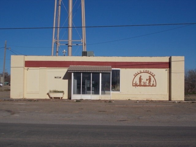
301 Ne 5Th St
11446
N/100 OF LOTS 9-12 BLK 8 O T (ACKERLY) (PAL,S CORNER CAFE & STORE) IN ACKERLY
Commercialnec
DAWSON
B and X Area of moderate flood hazard, usually the area between the limits of the 100-year and 500-year floods.
Texas
2025
9-12
2025
0.18 AC
950401
Texas West Area
3,740 SF
Other Market Areas
NEARBY LISTINGS FOR SALE OR LEASE
-
-
View all Lamesa listings for sale on LoopNet.com
DEMOGRAPHICS near 301 Ne 5Th St
1 mile
3 mile
5 mile
2025 Total Population
49
81
247
2030 Population
49
80
242
Pop Growth 2025-2030
0.00%
(1.23%)
(2.02%)
Average Age
38
39
39
2025 Total Households
16
28
84
HH Growth 2025-2030
0.00%
(3.57%)
(1.19%)
Median Household Inc
$67,500
$74,999
$74,062
Avg Household Size
3.10
3.00
2.90
2025 Avg HH Vehicles
2.00
2.00
2.00
Median Home Value
$166,666
$150,000
$163,333
Median Year Built
1971
1970
1970
Nearby Places
Map Layers
Map Styles
 Street
 Aerial
Layers
 Traffic
 Biking
Places
Listings with unknown addresses are not visible on the map
- Restaurants
- Banks
- Shops
- Fitness
- Groceries
SALE & LEASE HISTORY
LISTING DATE
SALE/LEASE

Sep 24, 2016
For Sale
May 08, 2018
For Sale
Nearby Properties
Address
Land Use
TOTAL SIZE
Lot Size
Zoning
Address
Land Use
TOTAL SIZE
Lot Size
Zoning
94,717 SF
7.25 AC
Address
Land Use
TOTAL SIZE
Lot Size
Zoning
85,006 SF
200 AC
Address
Land Use
TOTAL SIZE
Lot Size
Zoning
24,974 SF
5.51 AC
Address
Land Use
TOTAL SIZE
Lot Size
Zoning
102,150 SF
9.75 AC
Address
Land Use
TOTAL SIZE
Lot Size
Zoning
37,850 SF
2.27 AC
Address
Land Use
TOTAL SIZE
Lot Size
Zoning
1 SF
1.77 AC
Address
Land Use
TOTAL SIZE
Lot Size
Zoning
11,311 SF
7.67 AC
Address
Land Use
TOTAL SIZE
Lot Size
Zoning
22,328 SF
12.09 AC
Address
Land Use
TOTAL SIZE
Lot Size
Zoning
72,000 SF
8.33 AC
Address
Land Use
TOTAL SIZE
Lot Size
Zoning
17,952 SF
1.79 AC
Address
Land Use
TOTAL SIZE
Lot Size
Zoning
3.08 AC
Address
Land Use
TOTAL SIZE
Lot Size
Zoning
98,600 SF
18.10 AC
Address
Land Use
TOTAL SIZE
Lot Size
Zoning
200,000 SF
8.89 AC
Address
Land Use
TOTAL SIZE
Lot Size
Zoning
11,496 SF
0.96 AC
Address
Land Use
TOTAL SIZE
Lot Size
Zoning
18,613 SF
1.10 AC
Address
Land Use
TOTAL SIZE
Lot Size
Zoning
8,280 SF
0.16 AC
Address
Land Use
TOTAL SIZE
Lot Size
Zoning
17,620 SF
1.60 AC
Address
Land Use
TOTAL SIZE
Lot Size
Zoning
78,655 SF
1.54 AC
Address
Land Use
TOTAL SIZE
Lot Size
Zoning
26,157 SF
1.12 AC
Address
Land Use
TOTAL SIZE
Lot Size
Zoning
40,000 SF
1.93 AC
Address
Land Use
TOTAL SIZE
Lot Size
Zoning
37,958 SF
0.87 AC
Address
Land Use
TOTAL SIZE
Lot Size
Zoning
19,088 SF
0.96 AC
Address
Land Use
TOTAL SIZE
Lot Size
Zoning
48,098 SF
10.80 AC
Address
Land Use
TOTAL SIZE
Lot Size
Zoning
1 SF
1.73 AC
Address
Land Use
TOTAL SIZE
Lot Size
Zoning
20,563 SF
0.85 AC
Address
Land Use
TOTAL SIZE
Lot Size
Zoning
36,000 SF
9.41 AC
Address
Land Use
TOTAL SIZE
Lot Size
Zoning
6,736 SF
0.71 AC
Address
Land Use
TOTAL SIZE
Lot Size
Zoning
34,650 SF
1.61 AC
Address
Land Use
TOTAL SIZE
Lot Size
Zoning
69,149 SF
12 AC
Address
Land Use
TOTAL SIZE
Lot Size
Zoning
11,016 SF
0.69 AC
The World's #1 Commercial Real Estate Marketplace
Connect with us
© 2026 CoStar Group
The information above has been obtained from sources believed reliable. While we do not doubt its accuracy we have not verified it and make no guarantee, warranty or representation about it. It is your responsibility to independently confirm its accuracy and completeness. Any projections, opinions, assumptions, or estimates used are for example only and do not represent the current or future performance of the property. The value of this transaction to you depends on tax and other factors which should be evaluated by your tax, financial, and legal advisors. You and your advisors should conduct a careful, independent investigation of the property to determine to your satisfaction the suitability of the property for your needs.