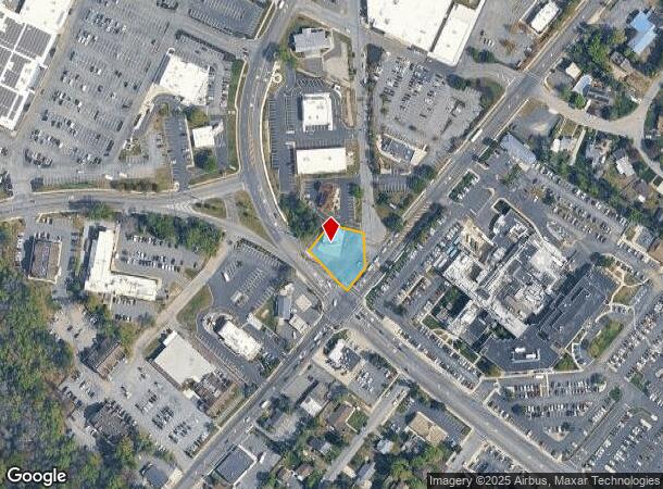
Property Record
301 Route 9 N, North Cape May, NJ 08204
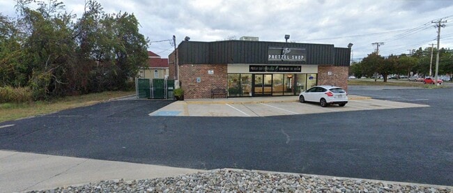

This Property Is For Sale
NEARBY LISTINGS FOR SALE OR LEASE
Property Detail
301 Route 9 N
06-00212-01-00001
Cape May
Storebuilding
New Jersey
X
1
34009C0229F
0.26 AC
2024
South Shore/Vineland
2025
Other Market Areas
021002
Ocean City, NJ
1,312 SF
DEMOGRAPHICS near 301 Route 9 N
1 Mile
3 Mile
5 Mile
2024 Total Population
1,760
5,319
14,768
2029 Population
1,567
4,822
14,384
Pop Growth 2024-2029
(10.97%)
(9.34%)
(2.60%)
Average Age
44
44
47
2024 Total Households
641
1,991
6,066
HH Growth 2024-2029
(13.88%)
(11.55%)
(2.60%)
Median Household Inc
$80,357
$80,425
$87,274
Avg Household Size
2.40
2.40
2.20
2024 Avg HH Vehicles
2.00
2.00
2.00
Median Home Value
$272,888
$277,008
$372,970
Median Year Built
1975
1983
1984
Nearby Places
Map Layers
Map Styles
 Street
 Aerial
- Restaurants
- Banks
- Shops
- Fitness
- Groceries
PUBLIC TRANSPORTATION
AIRPORT
Atlantic City International
DRIVE
WALK
Distance
Atlantic City International
63 min
34.8 mi
Freight Ports
Port of Wilmington, RI
DRIVE
WALK
Distance
Port of Wilmington, RI
100 min
69.6 mi
Nearby Properties
Address
Land Use
TOTAL SIZE
Lot Size
Zoning
Address
Land Use
TOTAL SIZE
Lot Size
Zoning
15.01 AC
TC
Address
Land Use
TOTAL SIZE
Lot Size
Zoning
60.73 AC
R
Address
Land Use
TOTAL SIZE
Lot Size
Zoning
150.47 AC
RRC
Address
Land Use
TOTAL SIZE
Lot Size
Zoning
15.38 AC
R
Address
Land Use
TOTAL SIZE
Lot Size
Zoning
117.32 AC
RRC
Address
Land Use
TOTAL SIZE
Lot Size
Zoning
7.93 AC
TB
Address
Land Use
TOTAL SIZE
Lot Size
Zoning
970 SF
12.30 AC
TBTR
Address
Land Use
TOTAL SIZE
Lot Size
Zoning
29.32 AC
RC
Address
Land Use
TOTAL SIZE
Lot Size
Zoning
18.61 AC
TC
Address
Land Use
TOTAL SIZE
Lot Size
Zoning
22.90 AC
TB
Address
Land Use
TOTAL SIZE
Lot Size
Zoning
7.98 AC
TCRC
Address
Land Use
TOTAL SIZE
Lot Size
Zoning
12.85 AC
R
Address
Land Use
TOTAL SIZE
Lot Size
Zoning
13.75 AC
R
Address
Land Use
TOTAL SIZE
Lot Size
Zoning
131.35 AC
RRC
Address
Land Use
TOTAL SIZE
Lot Size
Zoning
9.80 AC
R
Address
Land Use
TOTAL SIZE
Lot Size
Zoning
Address
Land Use
TOTAL SIZE
Lot Size
Zoning
6.37 AC
TB
Address
Land Use
TOTAL SIZE
Lot Size
Zoning
89.87 AC
RC
Address
Land Use
TOTAL SIZE
Lot Size
Zoning
20.31 AC
RRC
Address
Land Use
TOTAL SIZE
Lot Size
Zoning
98.94 AC
TCRC
Address
Land Use
TOTAL SIZE
Lot Size
Zoning
2.71 AC
VC
Address
Land Use
TOTAL SIZE
Lot Size
Zoning
177.38 AC
MIX
Address
Land Use
TOTAL SIZE
Lot Size
Zoning
46.08 AC
SR
Address
Land Use
TOTAL SIZE
Lot Size
Zoning
11.28 AC
TB
Address
Land Use
TOTAL SIZE
Lot Size
Zoning
2.50 AC
TC
Address
Land Use
TOTAL SIZE
Lot Size
Zoning
1,680 SF
1 AC
TB
Address
Land Use
TOTAL SIZE
Lot Size
Zoning
134.85 AC
SR
Address
Land Use
TOTAL SIZE
Lot Size
Zoning
5.18 AC
TC
Address
Land Use
TOTAL SIZE
Lot Size
Zoning
Address
Land Use
TOTAL SIZE
Lot Size
Zoning
The World's #1 Commercial Real Estate Marketplace
Connect with us
© 2025 CoStar Group
The information above has been obtained from sources believed reliable. While we do not doubt its accuracy we have not verified it and make no guarantee, warranty or representation about it. It is your responsibility to independently confirm its accuracy and completeness. Any projections, opinions, assumptions, or estimates used are for example only and do not represent the current or future performance of the property. The value of this transaction to you depends on tax and other factors which should be evaluated by your tax, financial, and legal advisors. You and your advisors should conduct a careful, independent investigation of the property to determine to your satisfaction the suitability of the property for your needs.