Property Record
301 S 2Nd St, Waco, TX 76701

Save to a Folder
{{folder.Name}}
{{folder.ListingIds.length}} Properties
{{folder.ListingIds.length}} Property
Create a New Folder
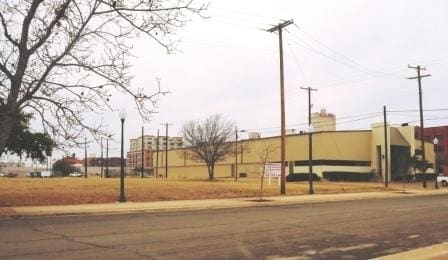
Property Detail
301 S 2Nd St
48-014931-000100-0
KRISHNA LONE STAR LLC LOT 1 BLOCK 1 ACRES 2.812
Commercialacreage
McLennan
2007TIF
Texas
B and X Area of moderate flood hazard, usually the area between the limits of the 100-year and 500-year floods.
1
2024
2.81 AC
2025
Downtown Waco
000100
Other Market Areas
27,340 SF
Waco, TX
NEARBY LISTINGS FOR SALE OR LEASE
DEMOGRAPHICS near 301 S 2Nd St
1 mile
3 mile
5 mile
2025 Total Population
10,750
75,796
132,967
2030 Population
11,176
78,780
137,581
Pop Growth 2025-2030
+ 3.96%
+ 3.94%
+ 3.47%
Average Age
28
33
35
2025 Total Households
2,969
26,870
49,853
HH Growth 2025-2030
+ 6.20%
+ 4.18%
+ 3.55%
Median Household Inc
$24,882
$36,908
$44,797
Avg Household Size
2.20
2.50
2.50
2025 Avg HH Vehicles
2.00
2.00
2.00
Median Home Value
$126,470
$149,588
$182,566
Median Year Built
1986
1972
1973
Nearby Places
Map Layers
Map Styles
 Street
 Aerial
Layers
 Traffic
 Biking
Places
Listings with unknown addresses are not visible on the map
- Restaurants
- Banks
- Shops
- Fitness
- Groceries
PUBLIC TRANSPORTATION
AIRPORT
Waco Regional
Drive
Walk
Distance
Waco Regional
20 min
8.9 mi
Freight Ports
Port of Houston
Drive
Walk
Distance
Port of Houston
215 min
185.8 mi
Nearby Properties
Address
Land Use
TOTAL SIZE
Lot Size
Zoning
Address
Land Use
TOTAL SIZE
Lot Size
Zoning
93.17 AC
2007 TIF
Address
Land Use
TOTAL SIZE
Lot Size
Zoning
549,274 SF
34.05 AC
O2
Address
Land Use
TOTAL SIZE
Lot Size
Zoning
120,623 SF
55.15 AC
2007 TIF
Address
Land Use
TOTAL SIZE
Lot Size
Zoning
560,620 SF
3.70 AC
O2
Address
Land Use
TOTAL SIZE
Lot Size
Zoning
576,501 SF
4.21 AC
Address
Land Use
TOTAL SIZE
Lot Size
Zoning
394,674 SF
21.31 AC
O2
Address
Land Use
TOTAL SIZE
Lot Size
Zoning
206,452 SF
11.97 AC
2007 TIF
Address
Land Use
TOTAL SIZE
Lot Size
Zoning
339,476 SF
Address
Land Use
TOTAL SIZE
Lot Size
Zoning
250,924 SF
17.73 AC
O-2
Address
Land Use
TOTAL SIZE
Lot Size
Zoning
27.28 AC
C
Address
Land Use
TOTAL SIZE
Lot Size
Zoning
399,747 SF
2.86 AC
C-3,C
Address
Land Use
TOTAL SIZE
Lot Size
Zoning
139,104 SF
12.86 AC
M1
Address
Land Use
TOTAL SIZE
Lot Size
Zoning
24.75 AC
O2
Address
Land Use
TOTAL SIZE
Lot Size
Zoning
213,814 SF
7.05 AC
2007 TIF
Address
Land Use
TOTAL SIZE
Lot Size
Zoning
69,809 SF
8.12 AC
2007 TIF
Address
Land Use
TOTAL SIZE
Lot Size
Zoning
3,096 SF
51.73 AC
2007 TIF
Address
Land Use
TOTAL SIZE
Lot Size
Zoning
126,592 SF
5.05 AC
2007 TIF
Address
Land Use
TOTAL SIZE
Lot Size
Zoning
188,746 SF
1.14 AC
O2
Address
Land Use
TOTAL SIZE
Lot Size
Zoning
188,465 SF
5.85 AC
2007 TIF
Address
Land Use
TOTAL SIZE
Lot Size
Zoning
Address
Land Use
TOTAL SIZE
Lot Size
Zoning
136,295 SF
6.09 AC
2007 TIF
Address
Land Use
TOTAL SIZE
Lot Size
Zoning
193,780 SF
14.12 AC
C
Address
Land Use
TOTAL SIZE
Lot Size
Zoning
237,081 SF
12.52 AC
2007 TIF
Address
Land Use
TOTAL SIZE
Lot Size
Zoning
107,925 SF
2.20 AC
2007TIF
Address
Land Use
TOTAL SIZE
Lot Size
Zoning
16.78 AC
2007 TIF
Address
Land Use
TOTAL SIZE
Lot Size
Zoning
200,951 SF
7.09 AC
R-3E
Address
Land Use
TOTAL SIZE
Lot Size
Zoning
77,089 SF
5.09 AC
O2
Address
Land Use
TOTAL SIZE
Lot Size
Zoning
155,900 SF
2.85 AC
O2
Address
Land Use
TOTAL SIZE
Lot Size
Zoning
142,734 SF
18.95 AC
R1B
Address
Land Use
TOTAL SIZE
Lot Size
Zoning
206,113 SF
7.33 AC
2007TIF
The World's #1 Commercial Real Estate Marketplace
Connect with us
© 2026 CoStar Group
The information above has been obtained from sources believed reliable. While we do not doubt its accuracy we have not verified it and make no guarantee, warranty or representation about it. It is your responsibility to independently confirm its accuracy and completeness. Any projections, opinions, assumptions, or estimates used are for example only and do not represent the current or future performance of the property. The value of this transaction to you depends on tax and other factors which should be evaluated by your tax, financial, and legal advisors. You and your advisors should conduct a careful, independent investigation of the property to determine to your satisfaction the suitability of the property for your needs.