Property Record
301 S B St, Madera, CA 93638

Save to a Folder
{{folder.Name}}
{{folder.ListingIds.length}} Properties
{{folder.ListingIds.length}} Property
Create a New Folder
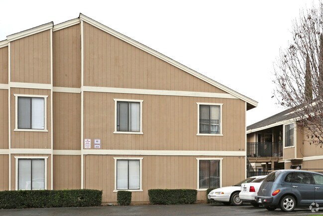
Property Detail
301 S B St
007-193-016
PAR 150 BY 100 SO B ST
Apartmenthouse5plusunits
MADERA
C and X Area of minimal flood hazard, usually depicted on FIRMs as above the 500-year flood level.
California
2025
0.56 AC
2026
Madera
000603
Fresno
28,653 SF
Fresno, CA
NEARBY LISTINGS FOR SALE OR LEASE
-
-
View all Madera listings for sale on LoopNet.com
DEMOGRAPHICS near 301 S B St
1 mile
3 mile
5 mile
2025 Total Population
21,877
78,534
88,265
2030 Population
22,754
81,699
91,842
Pop Growth 2025-2030
+ 4.01%
+ 4.03%
+ 4.05%
Average Age
32
33
34
2025 Total Households
5,512
20,595
23,278
HH Growth 2025-2030
+ 3.90%
+ 3.88%
+ 3.91%
Median Household Inc
$39,815
$57,218
$59,828
Avg Household Size
3.80
3.70
3.70
2025 Avg HH Vehicles
2.00
2.00
2.00
Median Home Value
$270,083
$357,572
$361,889
Median Year Built
1978
1990
1989
Nearby Places
Map Layers
Map Styles
 Street
 Aerial
Layers
 Traffic
 Biking
Places
Listings with unknown addresses are not visible on the map
- Restaurants
- Banks
- Shops
- Fitness
- Groceries
PUBLIC TRANSPORTATION
AIRPORT
Fresno Yosemite International
Drive
Walk
Distance
Fresno Yosemite International
36 min
25.1 mi
Freight Ports
Port of Stockton
Drive
Walk
Distance
Port of Stockton
127 min
106.0 mi
Nearby Properties
Address
Land Use
TOTAL SIZE
Lot Size
Zoning
Address
Land Use
TOTAL SIZE
Lot Size
Zoning
Address
Land Use
TOTAL SIZE
Lot Size
Zoning
20.26 AC
Address
Land Use
TOTAL SIZE
Lot Size
Zoning
2,830 SF
18.83 AC
ARE-20
Address
Land Use
TOTAL SIZE
Lot Size
Zoning
12.76 AC
Address
Land Use
TOTAL SIZE
Lot Size
Zoning
14,470 SF
21.28 AC
IL
Address
Land Use
TOTAL SIZE
Lot Size
Zoning
21.55 AC
Address
Land Use
TOTAL SIZE
Lot Size
Zoning
88,250 SF
11.24 AC
Address
Land Use
TOTAL SIZE
Lot Size
Zoning
4.92 AC
Address
Land Use
TOTAL SIZE
Lot Size
Zoning
33,180 SF
9.51 AC
Address
Land Use
TOTAL SIZE
Lot Size
Zoning
107,424 SF
12.05 AC
Address
Land Use
TOTAL SIZE
Lot Size
Zoning
144,440 SF
12.63 AC
Address
Land Use
TOTAL SIZE
Lot Size
Zoning
56,075 SF
1.20 AC
Address
Land Use
TOTAL SIZE
Lot Size
Zoning
1,836 SF
7.50 AC
Address
Land Use
TOTAL SIZE
Lot Size
Zoning
139,200 SF
10 AC
Address
Land Use
TOTAL SIZE
Lot Size
Zoning
87,739 SF
4.14 AC
Address
Land Use
TOTAL SIZE
Lot Size
Zoning
6.43 AC
Address
Land Use
TOTAL SIZE
Lot Size
Zoning
10.78 AC
Address
Land Use
TOTAL SIZE
Lot Size
Zoning
20,800 SF
3.82 AC
Address
Land Use
TOTAL SIZE
Lot Size
Zoning
9,576 SF
3.42 AC
Address
Land Use
TOTAL SIZE
Lot Size
Zoning
8,604 SF
2.07 AC
Address
Land Use
TOTAL SIZE
Lot Size
Zoning
4.65 AC
RUM
Address
Land Use
TOTAL SIZE
Lot Size
Zoning
25,311 SF
0.77 AC
Address
Land Use
TOTAL SIZE
Lot Size
Zoning
3,163 SF
0.60 AC
Address
Land Use
TOTAL SIZE
Lot Size
Zoning
42,475 SF
2.35 AC
Address
Land Use
TOTAL SIZE
Lot Size
Zoning
51,300 SF
11.59 AC
Address
Land Use
TOTAL SIZE
Lot Size
Zoning
23,540 SF
2.55 AC
Address
Land Use
TOTAL SIZE
Lot Size
Zoning
58,499 SF
1.59 AC
The World's #1 Commercial Real Estate Marketplace
Connect with us
© 2026 CoStar Group
The information above has been obtained from sources believed reliable. While we do not doubt its accuracy we have not verified it and make no guarantee, warranty or representation about it. It is your responsibility to independently confirm its accuracy and completeness. Any projections, opinions, assumptions, or estimates used are for example only and do not represent the current or future performance of the property. The value of this transaction to you depends on tax and other factors which should be evaluated by your tax, financial, and legal advisors. You and your advisors should conduct a careful, independent investigation of the property to determine to your satisfaction the suitability of the property for your needs.