Property Record
301 S Simmons St, Stockton, IL 61085


NEARBY LISTINGS FOR SALE OR LEASE
-
-
View all Stockton listings for sale on LoopNet.com
Property Detail
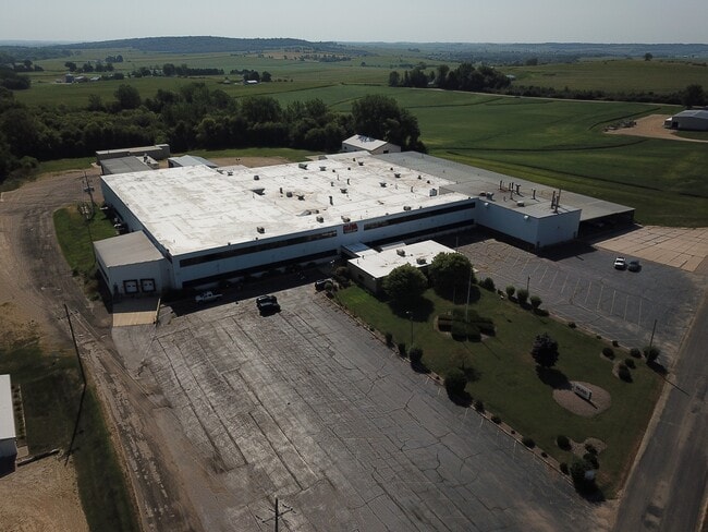
301 S Simmons St
Industrialgeneral
S12 T27N R4E PT W 12 SW
X
Jo Daviess
17177C0275C
Illinois
2024
19.31 AC
2024
Illinois North Area
020500
Other Market Areas
10,213 SF
17-002-160-00
DEMOGRAPHICS near 301 S Simmons St
1 Mile
3 Mile
5 Mile
2024 Total Population
1,733
1,970
2,432
2029 Population
1,700
1,920
2,353
Pop Growth 2024-2029
(1.90%)
(2.54%)
(3.25%)
Average Age
44
44
44
2024 Total Households
761
864
1,056
HH Growth 2024-2029
(2.10%)
(2.78%)
(3.60%)
Median Household Inc
$48,874
$50,608
$53,411
Avg Household Size
2.20
2.20
2.20
2024 Avg HH Vehicles
2.00
2.00
2.00
Median Home Value
$72,378
$79,004
$90,534
Median Year Built
1951
1953
1956
Nearby Places
Map Layers
Map Styles
 Street
 Aerial
- Restaurants
- Banks
- Shops
- Fitness
- Groceries
SALE & LEASE HISTORY
LISTING DATE
SALE/LEASE

Dec 11, 2020
For Sale
Nearby Properties
Address
Land Use
TOTAL SIZE
Lot Size
Zoning
Address
Land Use
TOTAL SIZE
Lot Size
Zoning
33.47 AC
Address
Land Use
TOTAL SIZE
Lot Size
Zoning
22,761 SF
2.16 AC
Address
Land Use
TOTAL SIZE
Lot Size
Zoning
128.20 AC
Address
Land Use
TOTAL SIZE
Lot Size
Zoning
7.50 AC
Address
Land Use
TOTAL SIZE
Lot Size
Zoning
2,528 SF
19.46 AC
Address
Land Use
TOTAL SIZE
Lot Size
Zoning
2.45 AC
Address
Land Use
TOTAL SIZE
Lot Size
Zoning
13.92 AC
Address
Land Use
TOTAL SIZE
Lot Size
Zoning
25,438 SF
1.70 AC
Address
Land Use
TOTAL SIZE
Lot Size
Zoning
Address
Land Use
TOTAL SIZE
Lot Size
Zoning
1.87 AC
Address
Land Use
TOTAL SIZE
Lot Size
Zoning
4.05 AC
Address
Land Use
TOTAL SIZE
Lot Size
Zoning
1,848 SF
162.50 AC
Address
Land Use
TOTAL SIZE
Lot Size
Zoning
53.52 AC
Address
Land Use
TOTAL SIZE
Lot Size
Zoning
114.93 AC
Address
Land Use
TOTAL SIZE
Lot Size
Zoning
15,021 SF
1.77 AC
Address
Land Use
TOTAL SIZE
Lot Size
Zoning
Address
Land Use
TOTAL SIZE
Lot Size
Zoning
Address
Land Use
TOTAL SIZE
Lot Size
Zoning
305.10 AC
Address
Land Use
TOTAL SIZE
Lot Size
Zoning
2,340 SF
6.74 AC
Address
Land Use
TOTAL SIZE
Lot Size
Zoning
Address
Land Use
TOTAL SIZE
Lot Size
Zoning
5.01 AC
Address
Land Use
TOTAL SIZE
Lot Size
Zoning
238.75 AC
Address
Land Use
TOTAL SIZE
Lot Size
Zoning
411.94 AC
Address
Land Use
TOTAL SIZE
Lot Size
Zoning
228.43 AC
Address
Land Use
TOTAL SIZE
Lot Size
Zoning
Address
Land Use
TOTAL SIZE
Lot Size
Zoning
1.37 AC
Address
Land Use
TOTAL SIZE
Lot Size
Zoning
14,417 SF
0.77 AC
Address
Land Use
TOTAL SIZE
Lot Size
Zoning
297.40 AC
Address
Land Use
TOTAL SIZE
Lot Size
Zoning
1.62 AC
The World's #1 Commercial Real Estate Marketplace
Connect with us
© 2026 CoStar Group
The information above has been obtained from sources believed reliable. While we do not doubt its accuracy we have not verified it and make no guarantee, warranty or representation about it. It is your responsibility to independently confirm its accuracy and completeness. Any projections, opinions, assumptions, or estimates used are for example only and do not represent the current or future performance of the property. The value of this transaction to you depends on tax and other factors which should be evaluated by your tax, financial, and legal advisors. You and your advisors should conduct a careful, independent investigation of the property to determine to your satisfaction the suitability of the property for your needs.