Property Record
301 S State St, Newtown, PA 18940
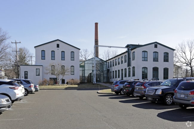
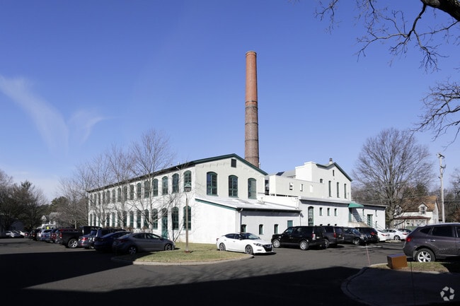
Property Detail
301 S State St
28-004-044
INCL 28-4-49 3.89A SE COR STERLING & CHAN CELLOR
Officebuilding
Bucks
VI
Pennsylvania
B and X Area of moderate flood hazard, usually the area between the limits of the 100-year and 500-year floods.
3.89 AC
2024
Lower Bucks County
2025
Philadelphia
105300
Philadelphia-Camden-Wilmington, PA-NJ-DE-MD
34,186 SF
NEARBY LISTINGS FOR SALE OR LEASE
DEMOGRAPHICS near 301 S State St
1 mile
3 mile
5 mile
2025 Total Population
8,718
47,751
122,261
2030 Population
8,732
47,893
122,651
Pop Growth 2025-2030
+ 0.16%
+ 0.30%
+ 0.32%
Average Age
46
45
45
2025 Total Households
3,700
18,340
45,475
HH Growth 2025-2030
+ 0.14%
+ 0.19%
+ 0.27%
Median Household Inc
$126,514
$138,821
$137,927
Avg Household Size
2.30
2.50
2.60
2025 Avg HH Vehicles
2.00
2.00
2.00
Median Home Value
$595,867
$632,658
$581,567
Median Year Built
1981
1984
1982
Nearby Places
Map Layers
Map Styles
 Street
 Aerial
Layers
 Traffic
 Biking
Places
Listings with unknown addresses are not visible on the map
- Restaurants
- Banks
- Shops
- Fitness
- Groceries
PUBLIC TRANSPORTATION
COMMUTER RAIL
Langhorne (R3 - Southeastern Pennsylvania Transportation Authority Regional Rail (SEPTA Regional Rail))
Drive
Walk
Distance
Langhorne (R3 - Southeastern Pennsylvania Transportation Authority Regional Rail (SEPTA Regional Rail))
9 min
4.7 mi
Woodbourne (R3 - Southeastern Pennsylvania Transportation Authority Regional Rail (SEPTA Regional Rail))
Drive
Walk
Distance
Woodbourne (R3 - Southeastern Pennsylvania Transportation Authority Regional Rail (SEPTA Regional Rail))
11 min
7.0 mi
AIRPORT
Trenton Mercer
Drive
Walk
Distance
Trenton Mercer
16 min
9.6 mi
Philadelphia International
Drive
Walk
Distance
Philadelphia International
58 min
36.7 mi
Freight Ports
Port of Philadelphia
Drive
Walk
Distance
Port of Philadelphia
38 min
23.0 mi
Nearby Properties
Address
Land Use
TOTAL SIZE
Lot Size
Zoning
Address
Land Use
TOTAL SIZE
Lot Size
Zoning
170,342 SF
28.26 AC
PC
Address
Land Use
TOTAL SIZE
Lot Size
Zoning
10,350 SF
35.55 AC
R4
Address
Land Use
TOTAL SIZE
Lot Size
Zoning
58,221 SF
14.42 AC
R1
Address
Land Use
TOTAL SIZE
Lot Size
Zoning
381,016 SF
52.25 AC
OR
Address
Land Use
TOTAL SIZE
Lot Size
Zoning
113,929 SF
10.43 AC
VRI
Address
Land Use
TOTAL SIZE
Lot Size
Zoning
78,743 SF
44.63 AC
IP
Address
Land Use
TOTAL SIZE
Lot Size
Zoning
104,466 SF
1.81 AC
OR
Address
Land Use
TOTAL SIZE
Lot Size
Zoning
57,804 SF
20.69 AC
AO
Address
Land Use
TOTAL SIZE
Lot Size
Zoning
102,348 SF
0.60 AC
RA
Address
Land Use
TOTAL SIZE
Lot Size
Zoning
104,204 SF
12.99 AC
RA3
Address
Land Use
TOTAL SIZE
Lot Size
Zoning
162,990 SF
10.75 AC
LI
Address
Land Use
TOTAL SIZE
Lot Size
Zoning
104,466 SF
1.91 AC
OR
Address
Land Use
TOTAL SIZE
Lot Size
Zoning
131,927 SF
14.73 AC
LI
Address
Land Use
TOTAL SIZE
Lot Size
Zoning
106,250 SF
14.41 AC
OR
Address
Land Use
TOTAL SIZE
Lot Size
Zoning
94,737 SF
1.66 AC
OR
Address
Land Use
TOTAL SIZE
Lot Size
Zoning
11.77 AC
R1
Address
Land Use
TOTAL SIZE
Lot Size
Zoning
151,803 SF
12.54 AC
LI
Address
Land Use
TOTAL SIZE
Lot Size
Zoning
65,124 SF
8.52 AC
PG
Address
Land Use
TOTAL SIZE
Lot Size
Zoning
16,170 SF
40 AC
OR
Address
Land Use
TOTAL SIZE
Lot Size
Zoning
35,713 SF
7.09 AC
L1
Address
Land Use
TOTAL SIZE
Lot Size
Zoning
78,848 SF
0.70 AC
Address
Land Use
TOTAL SIZE
Lot Size
Zoning
64,164 SF
8.29 AC
PC
Address
Land Use
TOTAL SIZE
Lot Size
Zoning
1.31 AC
OR
Address
Land Use
TOTAL SIZE
Lot Size
Zoning
109,704 SF
14.12 AC
LI
Address
Land Use
TOTAL SIZE
Lot Size
Zoning
114,710 SF
10.93 AC
R4
Address
Land Use
TOTAL SIZE
Lot Size
Zoning
73,245 SF
24.10 AC
OR
Address
Land Use
TOTAL SIZE
Lot Size
Zoning
90,400 SF
10.46 AC
OR
Address
Land Use
TOTAL SIZE
Lot Size
Zoning
76,984 SF
1.23 AC
OR
Address
Land Use
TOTAL SIZE
Lot Size
Zoning
48,948 SF
4.48 AC
VRI
Address
Land Use
TOTAL SIZE
Lot Size
Zoning
20,439 SF
0.87 AC
OR
The World's #1 Commercial Real Estate Marketplace
Connect with us
© 2026 CoStar Group
The information above has been obtained from sources believed reliable. While we do not doubt its accuracy we have not verified it and make no guarantee, warranty or representation about it. It is your responsibility to independently confirm its accuracy and completeness. Any projections, opinions, assumptions, or estimates used are for example only and do not represent the current or future performance of the property. The value of this transaction to you depends on tax and other factors which should be evaluated by your tax, financial, and legal advisors. You and your advisors should conduct a careful, independent investigation of the property to determine to your satisfaction the suitability of the property for your needs.