Property Record
301 Telluride St, San Marcos, TX 78666
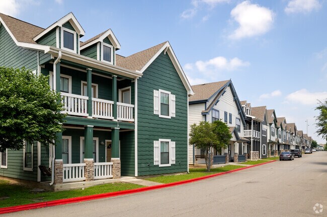
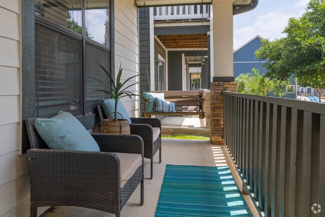
Property Detail
301 Telluride St
Austin-Round Rock-San Marcos, TX
ASPEN HEIGHTS, LOT 1, ACRES 20.654, (AND BUSINESS PERSONAL PROPERTY)
R137915
HAYS
Multifamilydwelling
Texas
B and X Area of moderate flood hazard, usually the area between the limits of the 100-year and 500-year floods.
1
2024
18.33 AC
2025
San Marcos
010309
Austin
306,818 SF
NEARBY LISTINGS FOR SALE OR LEASE
DEMOGRAPHICS near 301 Telluride St
1 mile
3 mile
5 mile
2025 Total Population
14,813
47,244
85,188
2030 Population
16,682
53,681
98,125
Pop Growth 2025-2030
+ 12.62%
+ 13.63%
+ 15.19%
Average Age
28
29
33
2025 Total Households
6,957
18,717
33,309
HH Growth 2025-2030
+ 13.34%
+ 14.96%
+ 16.30%
Median Household Inc
$44,462
$46,232
$54,173
Avg Household Size
2.00
2.10
2.30
2025 Avg HH Vehicles
2.00
2.00
2.00
Median Home Value
$81,585
$199,701
$316,771
Median Year Built
1998
1996
2000
Nearby Places
Map Layers
Map Styles
 Street
 Aerial
Layers
 Traffic
 Biking
Places
Listings with unknown addresses are not visible on the map
- Restaurants
- Banks
- Shops
- Fitness
- Groceries
PUBLIC TRANSPORTATION
COMMUTER RAIL
San Marcos Amtrak (Texas Eagle - Amtrak)
Drive
Walk
Distance
San Marcos Amtrak (Texas Eagle - Amtrak)
8 min
3.3 mi
AIRPORT
Austin-Bergstrom International
Drive
Walk
Distance
Austin-Bergstrom International
47 min
34.9 mi
Freight Ports
Calhoun Port
Drive
Walk
Distance
Calhoun Port
167 min
136.2 mi
Nearby Properties
Address
Land Use
TOTAL SIZE
Lot Size
Zoning
Address
Land Use
TOTAL SIZE
Lot Size
Zoning
13,158 SF
457.48 AC
Address
Land Use
TOTAL SIZE
Lot Size
Zoning
623,823 SF
1.46 AC
Address
Land Use
TOTAL SIZE
Lot Size
Zoning
215,932 SF
3.67 AC
Address
Land Use
TOTAL SIZE
Lot Size
Zoning
419,973 SF
23.69 AC
Address
Land Use
TOTAL SIZE
Lot Size
Zoning
324,430 SF
23.60 AC
Address
Land Use
TOTAL SIZE
Lot Size
Zoning
479,270 SF
24.78 AC
Address
Land Use
TOTAL SIZE
Lot Size
Zoning
3,600 SF
1,376 AC
Address
Land Use
TOTAL SIZE
Lot Size
Zoning
545,643 SF
2.69 AC
Address
Land Use
TOTAL SIZE
Lot Size
Zoning
311,146 SF
5.11 AC
Address
Land Use
TOTAL SIZE
Lot Size
Zoning
264,570 SF
14.23 AC
Address
Land Use
TOTAL SIZE
Lot Size
Zoning
354,670 SF
13 AC
Address
Land Use
TOTAL SIZE
Lot Size
Zoning
327,917 SF
10.54 AC
Address
Land Use
TOTAL SIZE
Lot Size
Zoning
266,157 SF
14.70 AC
Address
Land Use
TOTAL SIZE
Lot Size
Zoning
278,193 SF
17.44 AC
Address
Land Use
TOTAL SIZE
Lot Size
Zoning
365,750 SF
19.65 AC
Address
Land Use
TOTAL SIZE
Lot Size
Zoning
215,696 SF
28.15 AC
Address
Land Use
TOTAL SIZE
Lot Size
Zoning
215,688 SF
10.36 AC
Address
Land Use
TOTAL SIZE
Lot Size
Zoning
300,779 SF
10.84 AC
Address
Land Use
TOTAL SIZE
Lot Size
Zoning
179,764 SF
3.27 AC
Address
Land Use
TOTAL SIZE
Lot Size
Zoning
193,192 SF
18.45 AC
Address
Land Use
TOTAL SIZE
Lot Size
Zoning
248,868 SF
17.77 AC
Address
Land Use
TOTAL SIZE
Lot Size
Zoning
4,173 SF
128.50 AC
Address
Land Use
TOTAL SIZE
Lot Size
Zoning
145,336 SF
0.87 AC
Address
Land Use
TOTAL SIZE
Lot Size
Zoning
185,184 SF
11.22 AC
Address
Land Use
TOTAL SIZE
Lot Size
Zoning
233,640 SF
12.99 AC
Address
Land Use
TOTAL SIZE
Lot Size
Zoning
211,562 SF
2.35 AC
Address
Land Use
TOTAL SIZE
Lot Size
Zoning
191,304 SF
11.25 AC
Address
Land Use
TOTAL SIZE
Lot Size
Zoning
171,536 SF
8.49 AC
Address
Land Use
TOTAL SIZE
Lot Size
Zoning
178,521 SF
1.40 AC
The World's #1 Commercial Real Estate Marketplace
Connect with us
© 2026 CoStar Group
The information above has been obtained from sources believed reliable. While we do not doubt its accuracy we have not verified it and make no guarantee, warranty or representation about it. It is your responsibility to independently confirm its accuracy and completeness. Any projections, opinions, assumptions, or estimates used are for example only and do not represent the current or future performance of the property. The value of this transaction to you depends on tax and other factors which should be evaluated by your tax, financial, and legal advisors. You and your advisors should conduct a careful, independent investigation of the property to determine to your satisfaction the suitability of the property for your needs.