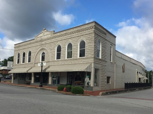
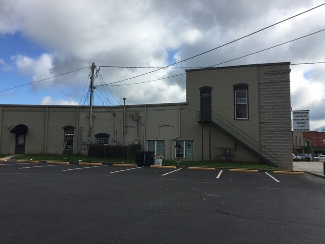
Property Record
307 Mann Rd, Barnesville, GA 30204
NEARBY LISTINGS FOR SALE OR LEASE
Property Detail
307 Mann Rd
B23-057
BUILDING AND LOT -307 MAIN STREET
Commercialnec
Lamar
X
Georgia
13171C0085C
307
2024
0.48 AC
2025
Lamar County
970202
Atlanta
8,185 SF
Atlanta-Sandy Springs-Roswell, GA
DEMOGRAPHICS near 307 Mann Rd
1 Mile
3 Mile
5 Mile
2024 Total Population
4,566
9,335
13,068
2029 Population
5,307
10,842
15,194
Pop Growth 2024-2029
+ 16.23%
+ 16.14%
+ 16.27%
Average Age
39
39
40
2024 Total Households
1,764
3,561
5,031
HH Growth 2024-2029
+ 17.12%
+ 17.02%
+ 16.94%
Median Household Inc
$41,886
$52,112
$53,950
Avg Household Size
2.40
2.40
2.50
2024 Avg HH Vehicles
2.00
2.00
2.00
Median Home Value
$159,865
$187,139
$193,431
Median Year Built
1973
1975
1979
Nearby Places
- Restaurants
- Banks
- Shops
- Fitness
- Groceries
SALE & LEASE HISTORY
LISTING DATE
SALE/LEASE

Sep 19, 2017
For Sale
Nov 01, 2018
For Sale
May 31, 2017
For Sale
Jun 22, 2017
For Sale
Nearby Properties
Address
Land Use
TOTAL SIZE
Lot Size
Zoning
Address
Land Use
TOTAL SIZE
Lot Size
Zoning
68,664 SF
23.35 AC
024
Address
Land Use
TOTAL SIZE
Lot Size
Zoning
104,598 SF
12.98 AC
002
Address
Land Use
TOTAL SIZE
Lot Size
Zoning
6,975 SF
92.88 AC
003
Address
Land Use
TOTAL SIZE
Lot Size
Zoning
2,886 SF
100 AC
001
Address
Land Use
TOTAL SIZE
Lot Size
Zoning
49.18 AC
I1
Address
Land Use
TOTAL SIZE
Lot Size
Zoning
93,212 SF
36.18 AC
AG
Address
Land Use
TOTAL SIZE
Lot Size
Zoning
130,170 SF
24.50 AC
C-4
Address
Land Use
TOTAL SIZE
Lot Size
Zoning
467,708 SF
79.13 AC
AR
Address
Land Use
TOTAL SIZE
Lot Size
Zoning
11,326 SF
58.66 AC
001
Address
Land Use
TOTAL SIZE
Lot Size
Zoning
22,413 SF
10 AC
C-3
Address
Land Use
TOTAL SIZE
Lot Size
Zoning
144,324 SF
10.67 AC
I-1
Address
Land Use
TOTAL SIZE
Lot Size
Zoning
22,500 SF
10 AC
Address
Land Use
TOTAL SIZE
Lot Size
Zoning
71,104 SF
4.03 AC
R-2
Address
Land Use
TOTAL SIZE
Lot Size
Zoning
28,079 SF
15.61 AC
001
Address
Land Use
TOTAL SIZE
Lot Size
Zoning
32,160 SF
8 AC
R-2
Address
Land Use
TOTAL SIZE
Lot Size
Zoning
20,898 SF
1.67 AC
001
Address
Land Use
TOTAL SIZE
Lot Size
Zoning
24,960 SF
2.52 AC
R-2
Address
Land Use
TOTAL SIZE
Lot Size
Zoning
115,705 SF
29.06 AC
001
Address
Land Use
TOTAL SIZE
Lot Size
Zoning
11,260 SF
4.50 AC
R-2
Address
Land Use
TOTAL SIZE
Lot Size
Zoning
24,590 SF
5.40 AC
R1-B
Address
Land Use
TOTAL SIZE
Lot Size
Zoning
4,108 SF
26.02 AC
001
Address
Land Use
TOTAL SIZE
Lot Size
Zoning
34,506 SF
4.51 AC
C-2
Address
Land Use
TOTAL SIZE
Lot Size
Zoning
13,320 SF
9.51 AC
R2
Address
Land Use
TOTAL SIZE
Lot Size
Zoning
14,859 SF
2.40 AC
C-4
Address
Land Use
TOTAL SIZE
Lot Size
Zoning
13,916 SF
18.43 AC
I-1
Address
Land Use
TOTAL SIZE
Lot Size
Zoning
11,520 SF
1.37 AC
019
Address
Land Use
TOTAL SIZE
Lot Size
Zoning
45,844 SF
6.26 AC
I-1
Address
Land Use
TOTAL SIZE
Lot Size
Zoning
23,040 SF
6.08 AC
R2
Address
Land Use
TOTAL SIZE
Lot Size
Zoning
12,954 SF
0.94 AC
C-2
Address
Land Use
TOTAL SIZE
Lot Size
Zoning
8,810 SF
1.29 AC
002
The World's #1 Commercial Real Estate Marketplace
Connect with us
© 2025 CoStar Group
The information above has been obtained from sources believed reliable. While we do not doubt its accuracy we have not verified it and make no guarantee, warranty or representation about it. It is your responsibility to independently confirm its accuracy and completeness. Any projections, opinions, assumptions, or estimates used are for example only and do not represent the current or future performance of the property. The value of this transaction to you depends on tax and other factors which should be evaluated by your tax, financial, and legal advisors. You and your advisors should conduct a careful, independent investigation of the property to determine to your satisfaction the suitability of the property for your needs.