Property Record
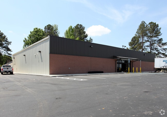
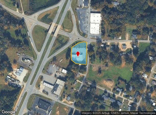
301 W Green St, Franklinton, NC 27525

NEARBY LISTINGS FOR SALE OR LEASE
-
-
View all Franklinton listings for sale on LoopNet.com
Property Detail
301 W Green St
Raleigh, NC
Chalk Tr
007460
DOLLAR GENERAL
Commercialnec
Franklin
X
North Carolina
3720184400K
2
2025
1.01 AC
2025
Franklin County
060404
Raleigh/Durham
9,100 SF
DEMOGRAPHICS near 301 W Green St
1 Mile
3 Mile
5 Mile
2024 Total Population
2,741
9,415
23,734
2029 Population
3,413
11,686
29,088
Pop Growth 2024-2029
+ 24.52%
+ 24.12%
+ 22.56%
Average Age
39
39
40
2024 Total Households
1,122
3,716
9,105
HH Growth 2024-2029
+ 24.33%
+ 24.06%
+ 22.47%
Median Household Inc
$46,320
$53,094
$63,609
Avg Household Size
2.40
2.50
2.60
2024 Avg HH Vehicles
2.00
2.00
2.00
Median Home Value
$150,253
$197,878
$246,224
Median Year Built
1979
1997
2002
Nearby Places
Map Layers
Map Styles
 Street
 Aerial
- Restaurants
- Banks
- Shops
- Fitness
- Groceries
PUBLIC TRANSPORTATION
AIRPORT
Raleigh-Durham International
DRIVE
WALK
Distance
Raleigh-Durham International
44 min
30.4 mi
Freight Ports
Virginia Port Authority - Richmond
DRIVE
WALK
Distance
Virginia Port Authority - Richmond
146 min
124.1 mi
Nearby Properties
Address
Land Use
TOTAL SIZE
Lot Size
Zoning
Address
Land Use
TOTAL SIZE
Lot Size
Zoning
42,428 SF
77.35 AC
FCO R-8
Address
Land Use
TOTAL SIZE
Lot Size
Zoning
63,604 SF
3.49 AC
C-2D
Address
Land Use
TOTAL SIZE
Lot Size
Zoning
3,813 SF
8.58 AC
MUD
Address
Land Use
TOTAL SIZE
Lot Size
Zoning
27,618 SF
10 AC
C-3H
Address
Land Use
TOTAL SIZE
Lot Size
Zoning
1,680 SF
6.20 AC
RSH
Address
Land Use
TOTAL SIZE
Lot Size
Zoning
58,186 SF
63.99 AC
FCO HI
Address
Land Use
TOTAL SIZE
Lot Size
Zoning
155.86 AC
FCO HI
Address
Land Use
TOTAL SIZE
Lot Size
Zoning
82.67 AC
LI
Address
Land Use
TOTAL SIZE
Lot Size
Zoning
4,271 SF
40.76 AC
C-3H
Address
Land Use
TOTAL SIZE
Lot Size
Zoning
12,600 SF
2.34 AC
C 3H
Address
Land Use
TOTAL SIZE
Lot Size
Zoning
10,956 SF
1.49 AC
C-3H
Address
Land Use
TOTAL SIZE
Lot Size
Zoning
82.74 AC
FCO GB
Address
Land Use
TOTAL SIZE
Lot Size
Zoning
306.51 AC
FCO AR
Address
Land Use
TOTAL SIZE
Lot Size
Zoning
53.51 AC
G B
Address
Land Use
TOTAL SIZE
Lot Size
Zoning
0.15 AC
LI
Address
Land Use
TOTAL SIZE
Lot Size
Zoning
8,700 SF
1.12 AC
C-3H
Address
Land Use
TOTAL SIZE
Lot Size
Zoning
78.03 AC
FCO HI
Address
Land Use
TOTAL SIZE
Lot Size
Zoning
285.97 AC
FCO AR
Address
Land Use
TOTAL SIZE
Lot Size
Zoning
11,002 SF
1.51 AC
C-3H
Address
Land Use
TOTAL SIZE
Lot Size
Zoning
5,857 SF
1.55 AC
C-2D
Address
Land Use
TOTAL SIZE
Lot Size
Zoning
4,464 SF
35.87 AC
PD
Address
Land Use
TOTAL SIZE
Lot Size
Zoning
104.46 AC
PD
Address
Land Use
TOTAL SIZE
Lot Size
Zoning
10,640 SF
1.87 AC
FCO AR
Address
Land Use
TOTAL SIZE
Lot Size
Zoning
22,548 SF
4.14 AC
FCO GB
Address
Land Use
TOTAL SIZE
Lot Size
Zoning
384.51 AC
FCO R-80
Address
Land Use
TOTAL SIZE
Lot Size
Zoning
600 SF
73.38 AC
FCO HI
Address
Land Use
TOTAL SIZE
Lot Size
Zoning
2,670 SF
1.86 AC
C-3H
Address
Land Use
TOTAL SIZE
Lot Size
Zoning
56.99 AC
FCO GB
Address
Land Use
TOTAL SIZE
Lot Size
Zoning
820 SF
4.18 AC
RMF
Address
Land Use
TOTAL SIZE
Lot Size
Zoning
4,150 SF
16.81 AC
FCO HI
The World's #1 Commercial Real Estate Marketplace
Connect with us
© 2025 CoStar Group
The information above has been obtained from sources believed reliable. While we do not doubt its accuracy we have not verified it and make no guarantee, warranty or representation about it. It is your responsibility to independently confirm its accuracy and completeness. Any projections, opinions, assumptions, or estimates used are for example only and do not represent the current or future performance of the property. The value of this transaction to you depends on tax and other factors which should be evaluated by your tax, financial, and legal advisors. You and your advisors should conduct a careful, independent investigation of the property to determine to your satisfaction the suitability of the property for your needs.