Property Record
301 White Oak Rd, Dayton, TN 37321


NEARBY LISTINGS FOR SALE OR LEASE
-
-
View all Dayton listings for lease on LoopNet.com
Property Detail
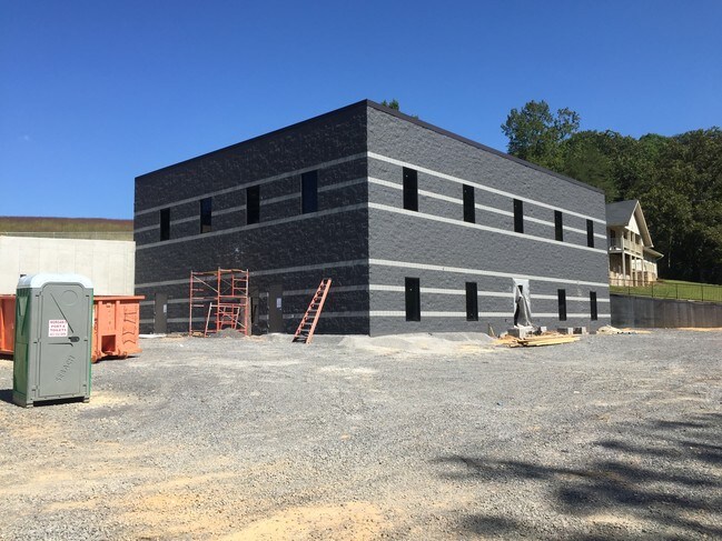
301 White Oak Rd
Dayton, TN
White Oak Ridge Subd
083-033.03
DISTRICT: 3; SUBDIVISION: WHITE OAK RIDGE SUBD
Medicalbuilding
Rhea
X
Tennessee
47121C0125F
2
0
0.72 AC
2025
Tennessee East Area
975200
Other Market Areas
9,880 SF
DEMOGRAPHICS near 301 White Oak Rd
1 Mile
3 Mile
5 Mile
2024 Total Population
995
8,603
16,271
2029 Population
1,042
9,042
17,072
Pop Growth 2024-2029
+ 4.72%
+ 5.10%
+ 4.92%
Average Age
39
39
39
2024 Total Households
373
3,262
6,225
HH Growth 2024-2029
+ 4.29%
+ 4.97%
+ 4.85%
Median Household Inc
$46,875
$44,466
$50,973
Avg Household Size
2.40
2.40
2.50
2024 Avg HH Vehicles
2.00
2.00
2.00
Median Home Value
$145,238
$148,958
$158,786
Median Year Built
1984
1986
1988
Nearby Places
Map Layers
Map Styles
 Street
 Aerial
- Restaurants
- Banks
- Shops
- Fitness
- Groceries
SALE & LEASE HISTORY
LISTING DATE
SALE/LEASE

Dec 30, 2016
For Lease
Nearby Properties
Address
Land Use
TOTAL SIZE
Lot Size
Zoning
Address
Land Use
TOTAL SIZE
Lot Size
Zoning
162,851 SF
135 AC
Address
Land Use
TOTAL SIZE
Lot Size
Zoning
110,795 SF
10.50 AC
C2
Address
Land Use
TOTAL SIZE
Lot Size
Zoning
580,002 SF
41.10 AC
Address
Land Use
TOTAL SIZE
Lot Size
Zoning
129,571 SF
18.64 AC
Address
Land Use
TOTAL SIZE
Lot Size
Zoning
68,614 SF
0.64 AC
Address
Land Use
TOTAL SIZE
Lot Size
Zoning
32,275 SF
6 AC
Address
Land Use
TOTAL SIZE
Lot Size
Zoning
278,896 SF
11.70 AC
Address
Land Use
TOTAL SIZE
Lot Size
Zoning
245,209 SF
10.48 AC
Address
Land Use
TOTAL SIZE
Lot Size
Zoning
11,038 SF
2 AC
Address
Land Use
TOTAL SIZE
Lot Size
Zoning
95,360 SF
16.88 AC
Address
Land Use
TOTAL SIZE
Lot Size
Zoning
2,198.19 AC
Address
Land Use
TOTAL SIZE
Lot Size
Zoning
106,600 SF
7 AC
Address
Land Use
TOTAL SIZE
Lot Size
Zoning
27,288 SF
1.80 AC
Address
Land Use
TOTAL SIZE
Lot Size
Zoning
71,520 SF
6.52 AC
Address
Land Use
TOTAL SIZE
Lot Size
Zoning
31,942 SF
2.55 AC
I2
Address
Land Use
TOTAL SIZE
Lot Size
Zoning
85,000 SF
9.01 AC
Address
Land Use
TOTAL SIZE
Lot Size
Zoning
107.89 AC
Address
Land Use
TOTAL SIZE
Lot Size
Zoning
16.44 AC
R1
Address
Land Use
TOTAL SIZE
Lot Size
Zoning
88,206 SF
11.69 AC
I2
Address
Land Use
TOTAL SIZE
Lot Size
Zoning
219,770 SF
39.92 AC
I2
Address
Land Use
TOTAL SIZE
Lot Size
Zoning
25,602 SF
2.64 AC
Address
Land Use
TOTAL SIZE
Lot Size
Zoning
26,927 SF
0.70 AC
Address
Land Use
TOTAL SIZE
Lot Size
Zoning
25.11 AC
Address
Land Use
TOTAL SIZE
Lot Size
Zoning
12,660 SF
1.51 AC
Address
Land Use
TOTAL SIZE
Lot Size
Zoning
3,264 SF
3.30 AC
Address
Land Use
TOTAL SIZE
Lot Size
Zoning
42,626 SF
5.75 AC
Address
Land Use
TOTAL SIZE
Lot Size
Zoning
9,030 SF
1.30 AC
Address
Land Use
TOTAL SIZE
Lot Size
Zoning
8,766 SF
1.10 AC
Address
Land Use
TOTAL SIZE
Lot Size
Zoning
4,232 SF
6.25 AC
Address
Land Use
TOTAL SIZE
Lot Size
Zoning
23,874 SF
0.74 AC
The World's #1 Commercial Real Estate Marketplace
Connect with us
© 2026 CoStar Group
The information above has been obtained from sources believed reliable. While we do not doubt its accuracy we have not verified it and make no guarantee, warranty or representation about it. It is your responsibility to independently confirm its accuracy and completeness. Any projections, opinions, assumptions, or estimates used are for example only and do not represent the current or future performance of the property. The value of this transaction to you depends on tax and other factors which should be evaluated by your tax, financial, and legal advisors. You and your advisors should conduct a careful, independent investigation of the property to determine to your satisfaction the suitability of the property for your needs.