Property Record
3010 Adams St, Mankato, MN 56001


Save to a Folder
{{folder.Name}}
{{folder.ListingIds.length}} Properties
{{folder.ListingIds.length}} Property
Create a New Folder
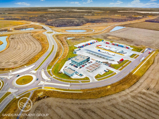
Property Detail
3010 Adams St
Mankato, MN
FREYBERG ADDITION LOT 1 BLOCK 1
R01.09.11.301.001
Blue Earth
Conveniencestore
Minnesota
B and X Area of moderate flood hazard, usually the area between the limits of the 100-year and 500-year floods.
1
2026
9.96 AC
2026
East Mankato
170200
Other Market Areas
15,050 SF
NEARBY LISTINGS FOR SALE OR LEASE
DEMOGRAPHICS near 3010 Adams St
1 mile
3 mile
5 mile
2025 Total Population
1,044
22,036
55,166
2030 Population
1,083
22,589
55,962
Pop Growth 2025-2030
+ 3.74%
+ 2.51%
+ 1.44%
Average Age
33
38
35
2025 Total Households
448
9,165
21,671
HH Growth 2025-2030
+ 4.02%
+ 2.67%
+ 1.48%
Median Household Inc
$72,599
$73,656
$65,465
Avg Household Size
2.30
2.30
2.30
2025 Avg HH Vehicles
2.00
2.00
2.00
Median Home Value
$356,799
$304,700
$268,594
Median Year Built
2011
1997
1982
Nearby Places
Map Layers
Map Styles
 Street
 Aerial
Layers
 Traffic
 Biking
Places
Listings with unknown addresses are not visible on the map
- Restaurants
- Banks
- Shops
- Fitness
- Groceries
SALE & LEASE HISTORY
LISTING DATE
SALE/LEASE

Jan 12, 2024
For Sale
Nearby Properties
Address
Land Use
TOTAL SIZE
Lot Size
Zoning
Address
Land Use
TOTAL SIZE
Lot Size
Zoning
666,816 SF
6.31 AC
Address
Land Use
TOTAL SIZE
Lot Size
Zoning
178,201 SF
64.49 AC
Address
Land Use
TOTAL SIZE
Lot Size
Zoning
458,428 SF
138.79 AC
Address
Land Use
TOTAL SIZE
Lot Size
Zoning
191,916 SF
37.68 AC
Address
Land Use
TOTAL SIZE
Lot Size
Zoning
481,569 SF
31.57 AC
Address
Land Use
TOTAL SIZE
Lot Size
Zoning
329,820 SF
18.94 AC
Address
Land Use
TOTAL SIZE
Lot Size
Zoning
287,085 SF
38 AC
Address
Land Use
TOTAL SIZE
Lot Size
Zoning
331,604 SF
35.88 AC
Address
Land Use
TOTAL SIZE
Lot Size
Zoning
47,274 SF
17.47 AC
Address
Land Use
TOTAL SIZE
Lot Size
Zoning
157,216 SF
31.67 AC
Address
Land Use
TOTAL SIZE
Lot Size
Zoning
137,968 SF
11.96 AC
Address
Land Use
TOTAL SIZE
Lot Size
Zoning
3.73 AC
Address
Land Use
TOTAL SIZE
Lot Size
Zoning
168,908 SF
5.71 AC
Address
Land Use
TOTAL SIZE
Lot Size
Zoning
144,504 SF
3.87 AC
Address
Land Use
TOTAL SIZE
Lot Size
Zoning
97,508 SF
44.54 AC
Address
Land Use
TOTAL SIZE
Lot Size
Zoning
63,880 SF
9.19 AC
Address
Land Use
TOTAL SIZE
Lot Size
Zoning
6.91 AC
Address
Land Use
TOTAL SIZE
Lot Size
Zoning
Address
Land Use
TOTAL SIZE
Lot Size
Zoning
Address
Land Use
TOTAL SIZE
Lot Size
Zoning
2.57 AC
Address
Land Use
TOTAL SIZE
Lot Size
Zoning
182,498 SF
23.67 AC
Address
Land Use
TOTAL SIZE
Lot Size
Zoning
279,442 SF
24.04 AC
Address
Land Use
TOTAL SIZE
Lot Size
Zoning
110,608 SF
8.55 AC
Address
Land Use
TOTAL SIZE
Lot Size
Zoning
107,485 SF
11.13 AC
Address
Land Use
TOTAL SIZE
Lot Size
Zoning
117,571 SF
17.45 AC
Address
Land Use
TOTAL SIZE
Lot Size
Zoning
3.14 AC
Address
Land Use
TOTAL SIZE
Lot Size
Zoning
90,180 SF
14.40 AC
The World's #1 Commercial Real Estate Marketplace
Connect with us
© 2026 CoStar Group
The information above has been obtained from sources believed reliable. While we do not doubt its accuracy we have not verified it and make no guarantee, warranty or representation about it. It is your responsibility to independently confirm its accuracy and completeness. Any projections, opinions, assumptions, or estimates used are for example only and do not represent the current or future performance of the property. The value of this transaction to you depends on tax and other factors which should be evaluated by your tax, financial, and legal advisors. You and your advisors should conduct a careful, independent investigation of the property to determine to your satisfaction the suitability of the property for your needs.