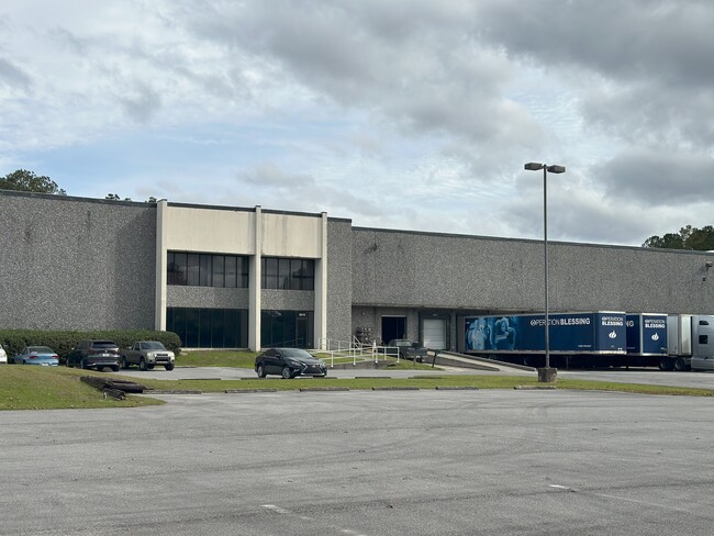
Property Record
3010 Ne 24Th St, Ocala, FL 34470

NEARBY LISTINGS FOR SALE OR LEASE
-
-
-
-
-
-
-
-
No Photo
-
View all Ocala listings for lease on LoopNet.com
Property Detail
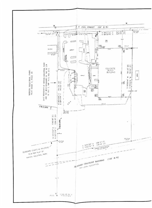
3010 Ne 24Th St
24264-001-01
SEC 03 TWP 15 RGE 22 COM AT S 1/4 COR TH N 1296.18 FT TO POB TH N 88-37-50 E 525.46 FT TH S 761.20 FT TH S 79-56-55 W 536.94 FT TH N 00-13-09 E 842.36 TO POB
Warehouse
Marion
A
Florida
12083C0528E
9.67 AC
2025
Greater Ocala
2025
Ocala
001403
Ocala, FL
61,162 SF
DEMOGRAPHICS near 3010 Ne 24Th St
1 Mile
3 Mile
5 Mile
2024 Total Population
5,097
43,285
87,094
2029 Population
5,710
48,628
98,053
Pop Growth 2024-2029
+ 12.03%
+ 12.34%
+ 12.58%
Average Age
45
40
41
2024 Total Households
2,491
18,060
35,753
HH Growth 2024-2029
+ 12.00%
+ 12.36%
+ 12.58%
Median Household Inc
$47,142
$52,256
$53,880
Avg Household Size
2.00
2.40
2.40
2024 Avg HH Vehicles
1.00
2.00
2.00
Median Home Value
$128,329
$170,779
$185,644
Median Year Built
1985
1978
1982
Nearby Places
Map Layers
Map Styles
 Street
 Aerial
- Restaurants
- Banks
- Shops
- Fitness
- Groceries
SALE & LEASE HISTORY
LISTING DATE
SALE/LEASE

Feb 02, 2024
For Lease
Nearby Properties
Address
Land Use
TOTAL SIZE
Lot Size
Zoning
Address
Land Use
TOTAL SIZE
Lot Size
Zoning
205,664 SF
22.56 AC
B5
Address
Land Use
TOTAL SIZE
Lot Size
Zoning
88,462 SF
31.76 AC
INST
Address
Land Use
TOTAL SIZE
Lot Size
Zoning
116,035 SF
38.20 AC
GU
Address
Land Use
TOTAL SIZE
Lot Size
Zoning
111,395 SF
13 AC
B2
Address
Land Use
TOTAL SIZE
Lot Size
Zoning
180,334 SF
24.29 AC
INST
Address
Land Use
TOTAL SIZE
Lot Size
Zoning
30,334 SF
34.53 AC
GU
Address
Land Use
TOTAL SIZE
Lot Size
Zoning
78,280 SF
12.54 AC
R3
Address
Land Use
TOTAL SIZE
Lot Size
Zoning
203,940 SF
29.65 AC
SC
Address
Land Use
TOTAL SIZE
Lot Size
Zoning
134,827 SF
14.83 AC
SC
Address
Land Use
TOTAL SIZE
Lot Size
Zoning
192,553 SF
21.18 AC
SC
Address
Land Use
TOTAL SIZE
Lot Size
Zoning
107,993 SF
66.76 AC
GU
Address
Land Use
TOTAL SIZE
Lot Size
Zoning
121,462 SF
10.92 AC
B2
Address
Land Use
TOTAL SIZE
Lot Size
Zoning
10,552 SF
51.60 AC
PRV
Address
Land Use
TOTAL SIZE
Lot Size
Zoning
134,890 SF
18.90 AC
B4
Address
Land Use
TOTAL SIZE
Lot Size
Zoning
35,356 SF
6.14 AC
R3
Address
Land Use
TOTAL SIZE
Lot Size
Zoning
58,040 SF
10.24 AC
INST
Address
Land Use
TOTAL SIZE
Lot Size
Zoning
81,689 SF
11.05 AC
B2
Address
Land Use
TOTAL SIZE
Lot Size
Zoning
81,174 SF
18.50 AC
B2
Address
Land Use
TOTAL SIZE
Lot Size
Zoning
50,369 SF
6.99 AC
B2
Address
Land Use
TOTAL SIZE
Lot Size
Zoning
22,083 SF
216.46 AC
B2
Address
Land Use
TOTAL SIZE
Lot Size
Zoning
47,567 SF
12 AC
INST
Address
Land Use
TOTAL SIZE
Lot Size
Zoning
27,949 SF
6.03 AC
R3
Address
Land Use
TOTAL SIZE
Lot Size
Zoning
14,344 SF
3.12 AC
B2
Address
Land Use
TOTAL SIZE
Lot Size
Zoning
55,809 SF
6.30 AC
M2
Address
Land Use
TOTAL SIZE
Lot Size
Zoning
39,552 SF
5.97 AC
R3
Address
Land Use
TOTAL SIZE
Lot Size
Zoning
64,190 SF
17.71 AC
INST
Address
Land Use
TOTAL SIZE
Lot Size
Zoning
36,064 SF
5.31 AC
R3
Address
Land Use
TOTAL SIZE
Lot Size
Zoning
91,003 SF
6.31 AC
B1
Address
Land Use
TOTAL SIZE
Lot Size
Zoning
22,868 SF
2.30 AC
R3
Address
Land Use
TOTAL SIZE
Lot Size
Zoning
60,099 SF
52.96 AC
B2
The World's #1 Commercial Real Estate Marketplace
Connect with us
© 2026 CoStar Group
The information above has been obtained from sources believed reliable. While we do not doubt its accuracy we have not verified it and make no guarantee, warranty or representation about it. It is your responsibility to independently confirm its accuracy and completeness. Any projections, opinions, assumptions, or estimates used are for example only and do not represent the current or future performance of the property. The value of this transaction to you depends on tax and other factors which should be evaluated by your tax, financial, and legal advisors. You and your advisors should conduct a careful, independent investigation of the property to determine to your satisfaction the suitability of the property for your needs.