Property Record
30105 State Highway 59, Loxley, AL 36551


NEARBY LISTINGS FOR SALE OR LEASE
Property Detail
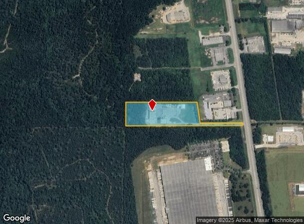
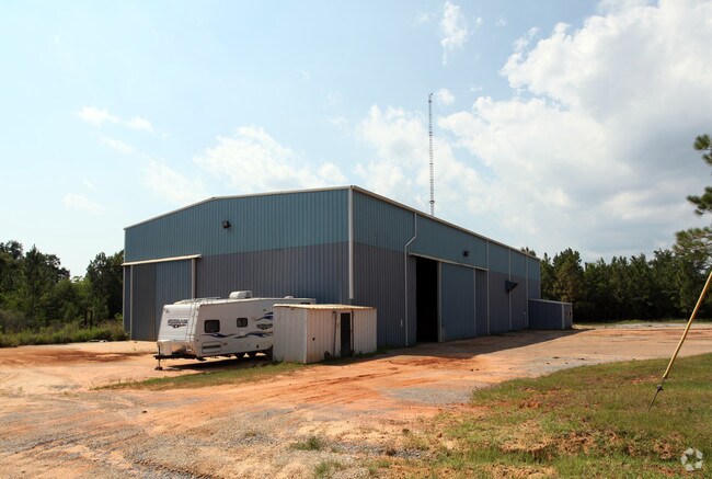
30105 State Highway 59
33-08-27-0-000-004.005
Orange Beach Comm Park
Warehouse
7.6 AC(C) BEG AT SW COR OF SEC 27 RUN E 1541'(S) TO E/L OF H WY 59, TH NW 40.4, TH W 566', TH NW 283', TH W 928.9, TH S 3 20'
X
Baldwin
01003C0542M
Alabama
2024
7.70 AC
2024
Baldwin County
010903
Mobile
14,265 SF
Daphne-Fairhope-Foley, AL
DEMOGRAPHICS near 30105 State Highway 59
1 Mile
3 Mile
5 Mile
2024 Total Population
28
3,191
15,179
2029 Population
32
3,615
17,239
Pop Growth 2024-2029
+ 14.29%
+ 13.29%
+ 13.57%
Average Age
40
37
37
2024 Total Households
11
1,137
5,363
HH Growth 2024-2029
+ 18.18%
+ 12.66%
+ 13.03%
Median Household Inc
$39,999
$57,929
$66,635
Avg Household Size
2.60
2.60
2.70
2024 Avg HH Vehicles
3.00
2.00
2.00
Median Home Value
$166,666
$213,853
$212,562
Median Year Built
1992
1996
2001
Nearby Places
Map Layers
Map Styles
 Street
 Aerial
- Restaurants
- Banks
- Shops
- Fitness
- Groceries
PUBLIC TRANSPORTATION
AIRPORT
Mobile International
DRIVE
WALK
Distance
Mobile International
30 min
22.8 mi
Mobile Regional
DRIVE
WALK
Distance
Mobile Regional
53 min
36.5 mi
Freight Ports
Port of Mobile
DRIVE
WALK
Distance
Port of Mobile
25 min
19.5 mi
SALE & LEASE HISTORY
LISTING DATE
SALE/LEASE

Sep 25, 2016
For Lease
Sep 23, 2016
For Sale
Oct 04, 2016
For Sale
Nearby Properties
Address
Land Use
TOTAL SIZE
Lot Size
Zoning
Address
Land Use
TOTAL SIZE
Lot Size
Zoning
583,381 SF
147 AC
Address
Land Use
TOTAL SIZE
Lot Size
Zoning
178,238 SF
15 AC
Address
Land Use
TOTAL SIZE
Lot Size
Zoning
827,037 SF
106 AC
Address
Land Use
TOTAL SIZE
Lot Size
Zoning
234,545 SF
12.20 AC
Address
Land Use
TOTAL SIZE
Lot Size
Zoning
125,294 SF
7 AC
Address
Land Use
TOTAL SIZE
Lot Size
Zoning
66,448 SF
8 AC
Address
Land Use
TOTAL SIZE
Lot Size
Zoning
81,447 SF
6.30 AC
Address
Land Use
TOTAL SIZE
Lot Size
Zoning
180,333 SF
7.60 AC
Address
Land Use
TOTAL SIZE
Lot Size
Zoning
144,122 SF
7.60 AC
Address
Land Use
TOTAL SIZE
Lot Size
Zoning
146,751 SF
7.10 AC
Address
Land Use
TOTAL SIZE
Lot Size
Zoning
163,200 SF
7.40 AC
Address
Land Use
TOTAL SIZE
Lot Size
Zoning
144,111 SF
6.90 AC
Address
Land Use
TOTAL SIZE
Lot Size
Zoning
174,174 SF
7 AC
Address
Land Use
TOTAL SIZE
Lot Size
Zoning
48,343 SF
3 AC
Address
Land Use
TOTAL SIZE
Lot Size
Zoning
4,613 SF
6.40 AC
Address
Land Use
TOTAL SIZE
Lot Size
Zoning
39,082 SF
1.67 AC
Address
Land Use
TOTAL SIZE
Lot Size
Zoning
42,423 SF
2.95 AC
Address
Land Use
TOTAL SIZE
Lot Size
Zoning
8,830 SF
4.40 AC
Address
Land Use
TOTAL SIZE
Lot Size
Zoning
24,920 SF
5.10 AC
Address
Land Use
TOTAL SIZE
Lot Size
Zoning
6,148 SF
1.12 AC
Address
Land Use
TOTAL SIZE
Lot Size
Zoning
20,000 SF
4.60 AC
Address
Land Use
TOTAL SIZE
Lot Size
Zoning
17,000 SF
6.90 AC
Address
Land Use
TOTAL SIZE
Lot Size
Zoning
6.60 AC
Address
Land Use
TOTAL SIZE
Lot Size
Zoning
73,949 SF
3 AC
Address
Land Use
TOTAL SIZE
Lot Size
Zoning
17,021 SF
0.81 AC
Address
Land Use
TOTAL SIZE
Lot Size
Zoning
18,053 SF
4 AC
Address
Land Use
TOTAL SIZE
Lot Size
Zoning
5,334 SF
2.51 AC
Address
Land Use
TOTAL SIZE
Lot Size
Zoning
24,640 SF
2.20 AC
Address
Land Use
TOTAL SIZE
Lot Size
Zoning
25,025 SF
2.40 AC
Address
Land Use
TOTAL SIZE
Lot Size
Zoning
14,656 SF
17 AC
The World's #1 Commercial Real Estate Marketplace
Connect with us
© 2025 CoStar Group
The information above has been obtained from sources believed reliable. While we do not doubt its accuracy we have not verified it and make no guarantee, warranty or representation about it. It is your responsibility to independently confirm its accuracy and completeness. Any projections, opinions, assumptions, or estimates used are for example only and do not represent the current or future performance of the property. The value of this transaction to you depends on tax and other factors which should be evaluated by your tax, financial, and legal advisors. You and your advisors should conduct a careful, independent investigation of the property to determine to your satisfaction the suitability of the property for your needs.