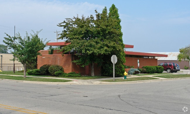
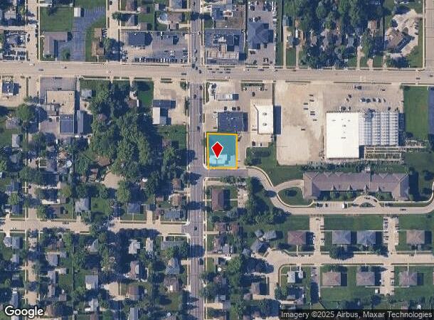
Property Record
3011 90Th St, Sturtevant, WI 53177
NEARBY LISTINGS FOR SALE OR LEASE
Property Detail
3011 90Th St
181-032227022000
PT NW1/4 COM 233S NW COR E40 E118 S135 W117 W40 N139 TO POB EXC HWY **TOTAL ACRES** 00.38
Commercialnec
Racine
X
Wisconsin
55101C0209D
0.38 AC
2024
Racine East
2024
Milwaukee/Madison
001702
Racine, WI
DEMOGRAPHICS near 3011 90Th St
1 Mile
3 Mile
5 Mile
2024 Total Population
5,438
23,575
81,826
2029 Population
5,373
23,461
81,177
Pop Growth 2024-2029
(1.20%)
(0.48%)
(0.79%)
Average Age
40
42
41
2024 Total Households
1,825
9,546
33,157
HH Growth 2024-2029
(0.93%)
(0.32%)
(0.82%)
Median Household Inc
$80,055
$67,156
$67,817
Avg Household Size
2.50
2.20
2.30
2024 Avg HH Vehicles
2.00
2.00
2.00
Median Home Value
$200,606
$221,778
$197,516
Median Year Built
1975
1979
1969
Nearby Places
Map Layers
Map Styles
 Street
 Aerial
- Restaurants
- Banks
- Shops
- Fitness
- Groceries
PUBLIC TRANSPORTATION
COMMUTER RAIL
Sturtevant Amtrak Station (Hiawatha Service - Amtrak)
DRIVE
WALK
Distance
Sturtevant Amtrak Station (Hiawatha Service - Amtrak)
6 min
2.8 mi
AIRPORT
General Mitchell International
DRIVE
WALK
Distance
General Mitchell International
30 min
22.5 mi
Freight Ports
Port Milwaukee
DRIVE
WALK
Distance
Port Milwaukee
34 min
26.4 mi
SALE & LEASE HISTORY
LISTING DATE
SALE/LEASE

Nov 01, 2021
For Sale
Jun 14, 2018
For Sale
Jun 08, 2021
For Sale
Nearby Properties
Address
Land Use
TOTAL SIZE
Lot Size
Zoning
Address
Land Use
TOTAL SIZE
Lot Size
Zoning
861.42 AC
Address
Land Use
TOTAL SIZE
Lot Size
Zoning
318.64 AC
Address
Land Use
TOTAL SIZE
Lot Size
Zoning
22.34 AC
Address
Land Use
TOTAL SIZE
Lot Size
Zoning
241.29 AC
Address
Land Use
TOTAL SIZE
Lot Size
Zoning
241.29 AC
Address
Land Use
TOTAL SIZE
Lot Size
Zoning
Address
Land Use
TOTAL SIZE
Lot Size
Zoning
9.40 AC
B-3
Address
Land Use
TOTAL SIZE
Lot Size
Zoning
23.10 AC
Address
Land Use
TOTAL SIZE
Lot Size
Zoning
37.55 AC
Address
Land Use
TOTAL SIZE
Lot Size
Zoning
47.01 AC
M-1
Address
Land Use
TOTAL SIZE
Lot Size
Zoning
32.55 AC
Address
Land Use
TOTAL SIZE
Lot Size
Zoning
57.80 AC
M1
Address
Land Use
TOTAL SIZE
Lot Size
Zoning
26.79 AC
Address
Land Use
TOTAL SIZE
Lot Size
Zoning
Address
Land Use
TOTAL SIZE
Lot Size
Zoning
Address
Land Use
TOTAL SIZE
Lot Size
Zoning
23.21 AC
Address
Land Use
TOTAL SIZE
Lot Size
Zoning
140.07 AC
Address
Land Use
TOTAL SIZE
Lot Size
Zoning
9.31 AC
Address
Land Use
TOTAL SIZE
Lot Size
Zoning
Address
Land Use
TOTAL SIZE
Lot Size
Zoning
30.45 AC
002
Address
Land Use
TOTAL SIZE
Lot Size
Zoning
18.33 AC
Address
Land Use
TOTAL SIZE
Lot Size
Zoning
20.61 AC
Address
Land Use
TOTAL SIZE
Lot Size
Zoning
19.29 AC
002
Address
Land Use
TOTAL SIZE
Lot Size
Zoning
5.74 AC
Address
Land Use
TOTAL SIZE
Lot Size
Zoning
Address
Land Use
TOTAL SIZE
Lot Size
Zoning
Address
Land Use
TOTAL SIZE
Lot Size
Zoning
22.98 AC
M-1
Address
Land Use
TOTAL SIZE
Lot Size
Zoning
32.99 AC
002
Address
Land Use
TOTAL SIZE
Lot Size
Zoning
Address
Land Use
TOTAL SIZE
Lot Size
Zoning
16.97 AC
The World's #1 Commercial Real Estate Marketplace
Connect with us
© 2025 CoStar Group
The information above has been obtained from sources believed reliable. While we do not doubt its accuracy we have not verified it and make no guarantee, warranty or representation about it. It is your responsibility to independently confirm its accuracy and completeness. Any projections, opinions, assumptions, or estimates used are for example only and do not represent the current or future performance of the property. The value of this transaction to you depends on tax and other factors which should be evaluated by your tax, financial, and legal advisors. You and your advisors should conduct a careful, independent investigation of the property to determine to your satisfaction the suitability of the property for your needs.