Property Record
3011 S Lindsay Rd, Gilbert, AZ 85295

Property Detail
3011 S Lindsay Rd
309-29-366
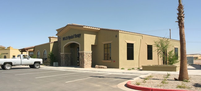
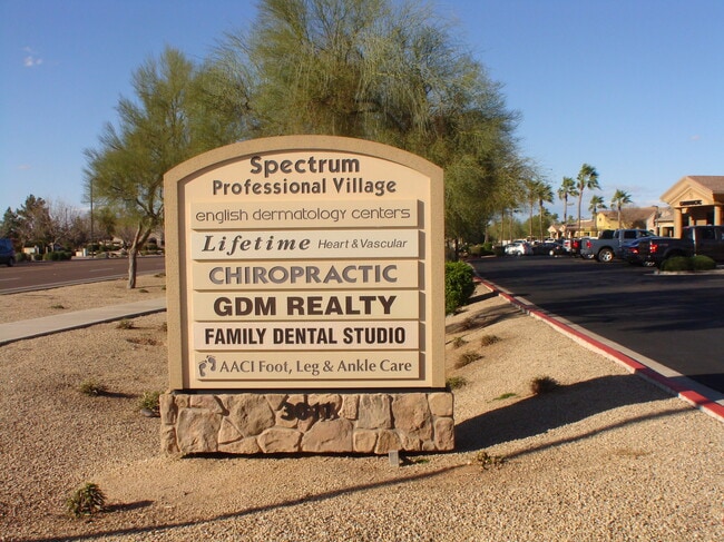
SPECTRUM PROFESSIONAL VILLAGE CONDOMINIUM MCR 677-13 UNIT 115 (PLEASE NOTE: FOR LEGAL DESCRIPTION REFERENCES REGARDING THE PERCENTAGE OF OWNERSHIP OF THECOMMON AREA(S), PLEASE REFER TO THE RECORDED COVENANTS, CONDITIONS AND RESTRICTIONS (CCR) ASSOCI
Officecondo
Maricopa
C-C
Arizona
C and X Area of minimal flood hazard, usually depicted on FIRMs as above the 500-year flood level.
115
2025
0.06 AC
2025
Gateway Airport/Loop 202
815402
Phoenix
5,088 SF
Phoenix-Mesa-Chandler, AZ
NEARBY LISTINGS FOR SALE OR LEASE
-
-
-
SEC of Melrose & Rome - 10 Medical/Office Condos
Gilbert, AZ 85297
$3,806,400 - $7,602,400
9,516 - 19,006 SF
Office
-
-
-
-
-
View all Gilbert listings for sale on LoopNet.com
DEMOGRAPHICS near 3011 S Lindsay Rd
1 mile
3 mile
5 mile
2025 Total Population
9,961
101,941
317,379
2030 Population
10,224
105,883
329,215
Pop Growth 2025-2030
+ 2.64%
+ 3.87%
+ 3.73%
Average Age
36
37
36
2025 Total Households
3,016
34,483
105,570
HH Growth 2025-2030
+ 2.92%
+ 3.95%
+ 3.74%
Median Household Inc
$153,768
$125,045
$119,418
Avg Household Size
3.20
2.90
2.90
2025 Avg HH Vehicles
2.00
2.00
2.00
Median Home Value
$707,926
$612,427
$597,220
Median Year Built
2005
2003
2002
Nearby Places
Map Layers
Map Styles
 Street
 Aerial
Layers
 Traffic
 Biking
Places
Listings with unknown addresses are not visible on the map
- Restaurants
- Banks
- Shops
- Fitness
- Groceries
PUBLIC TRANSPORTATION
AIRPORT
Phoenix-Mesa Gateway
Drive
Walk
Distance
Phoenix-Mesa Gateway
15 min
7.1 mi
Phoenix Sky Harbor International
Drive
Walk
Distance
Phoenix Sky Harbor International
33 min
24.5 mi
SALE & LEASE HISTORY
LISTING DATE
SALE/LEASE

Nov 29, 2023
For Sale
Nov 29, 2023
For Lease
Nearby Properties
Address
Land Use
TOTAL SIZE
Lot Size
Zoning
Address
Land Use
TOTAL SIZE
Lot Size
Zoning
837,332 SF
55.22 AC
PF
Address
Land Use
TOTAL SIZE
Lot Size
Zoning
Address
Land Use
TOTAL SIZE
Lot Size
Zoning
22.83 AC
PF
Address
Land Use
TOTAL SIZE
Lot Size
Zoning
288,023 SF
48.20 AC
PAD
Address
Land Use
TOTAL SIZE
Lot Size
Zoning
498,377 SF
29.12 AC
Address
Land Use
TOTAL SIZE
Lot Size
Zoning
2.91 AC
Address
Land Use
TOTAL SIZE
Lot Size
Zoning
479,727 SF
14.25 AC
MFM
Address
Land Use
TOTAL SIZE
Lot Size
Zoning
445,862 SF
36.70 AC
LI
Address
Land Use
TOTAL SIZE
Lot Size
Zoning
430,700 SF
63.32 AC
PF
Address
Land Use
TOTAL SIZE
Lot Size
Zoning
425,886 SF
19.08 AC
MFM
Address
Land Use
TOTAL SIZE
Lot Size
Zoning
465,645 SF
30.78 AC
PAD
Address
Land Use
TOTAL SIZE
Lot Size
Zoning
300,885 SF
37.63 AC
AG
Address
Land Use
TOTAL SIZE
Lot Size
Zoning
348,668 SF
8.97 AC
R3
Address
Land Use
TOTAL SIZE
Lot Size
Zoning
387,535 SF
15.80 AC
C-G
Address
Land Use
TOTAL SIZE
Lot Size
Zoning
324,283 SF
18.75 AC
PAD
Address
Land Use
TOTAL SIZE
Lot Size
Zoning
380,383 SF
14.79 AC
C-G
Address
Land Use
TOTAL SIZE
Lot Size
Zoning
362,701 SF
9.77 AC
R3
Address
Land Use
TOTAL SIZE
Lot Size
Zoning
335,464 SF
13.41 AC
Address
Land Use
TOTAL SIZE
Lot Size
Zoning
317,959 SF
23.86 AC
Address
Land Use
TOTAL SIZE
Lot Size
Zoning
332,112 SF
15.44 AC
M-M
Address
Land Use
TOTAL SIZE
Lot Size
Zoning
372,953 SF
14.36 AC
C-C
Address
Land Use
TOTAL SIZE
Lot Size
Zoning
159,419 SF
10.11 AC
RC
Address
Land Use
TOTAL SIZE
Lot Size
Zoning
275,813 SF
24.90 AC
R-CH
Address
Land Use
TOTAL SIZE
Lot Size
Zoning
316,979 SF
17.26 AC
MF/M
Address
Land Use
TOTAL SIZE
Lot Size
Zoning
267,868 SF
13.18 AC
R-CH
Address
Land Use
TOTAL SIZE
Lot Size
Zoning
316,658 SF
47.91 AC
PAD
Address
Land Use
TOTAL SIZE
Lot Size
Zoning
128,416 SF
8.28 AC
C-BP
Address
Land Use
TOTAL SIZE
Lot Size
Zoning
317,739 SF
14.05 AC
MF/M
Address
Land Use
TOTAL SIZE
Lot Size
Zoning
238,856 SF
6.53 AC
R3
Address
Land Use
TOTAL SIZE
Lot Size
Zoning
1.55 AC
The World's #1 Commercial Real Estate Marketplace
Connect with us
© 2026 CoStar Group
The information above has been obtained from sources believed reliable. While we do not doubt its accuracy we have not verified it and make no guarantee, warranty or representation about it. It is your responsibility to independently confirm its accuracy and completeness. Any projections, opinions, assumptions, or estimates used are for example only and do not represent the current or future performance of the property. The value of this transaction to you depends on tax and other factors which should be evaluated by your tax, financial, and legal advisors. You and your advisors should conduct a careful, independent investigation of the property to determine to your satisfaction the suitability of the property for your needs.