Property Record
3011 Sw Williston Rd, Gainesville, FL 32608
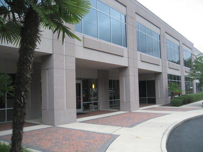


Property Detail
3011 Sw Williston Rd
07176-012-000
SERENOLA PLANTATION DB L-480 COM SW COR OF SERENOLA N 5 DEG W 2317.31 FT POB S 49 DEG W 166.99 FT S 40 DEG E 726 FT N 49 DEG E 300 FT N 40 DEG W 726 FT S 49 DEG W 133.01 FT POB OR 4056/1265
Officebuilding
Alachua
U7
Florida
B and X Area of moderate flood hazard, usually the area between the limits of the 100-year and 500-year floods.
480
2025
5.26 AC
2025
South Gainesville
110800
Other Market Areas
63,165 SF
Gainesville, FL
NEARBY LISTINGS FOR SALE OR LEASE
DEMOGRAPHICS near 3011 Sw Williston Rd
1 mile
3 mile
5 mile
2025 Total Population
10,368
56,048
135,941
2030 Population
10,688
57,977
140,691
Pop Growth 2025-2030
+ 3.09%
+ 3.44%
+ 3.49%
Average Age
30
30
33
2025 Total Households
4,669
21,507
54,561
HH Growth 2025-2030
+ 3.58%
+ 3.96%
+ 3.99%
Median Household Inc
$48,288
$44,180
$49,610
Avg Household Size
2.10
2.10
2.10
2025 Avg HH Vehicles
1.00
1.00
2.00
Median Home Value
$221,323
$277,471
$335,218
Median Year Built
1993
1990
1986
Nearby Places
Map Layers
Map Styles
 Street
 Aerial
Transit
 Traffic
 Biking
Places
Listings with unknown addresses are not visible on the map
- Restaurants
- Banks
- Shops
- Fitness
- Groceries
PUBLIC TRANSPORTATION
AIRPORT
Gainesville Regional
Drive
Walk
Distance
Gainesville Regional
21 min
9.5 mi
Nearby Properties
Address
Land Use
TOTAL SIZE
Lot Size
Zoning
Address
Land Use
TOTAL SIZE
Lot Size
Zoning
3,617,778 SF
276.74 AC
ED
Address
Land Use
TOTAL SIZE
Lot Size
Zoning
790,340 SF
526 AC
ED
Address
Land Use
TOTAL SIZE
Lot Size
Zoning
698,640 SF
24.04 AC
U9
Address
Land Use
TOTAL SIZE
Lot Size
Zoning
382,760 SF
109.58 AC
MD
Address
Land Use
TOTAL SIZE
Lot Size
Zoning
20.95 AC
MD
Address
Land Use
TOTAL SIZE
Lot Size
Zoning
1,142,852 SF
106.08 AC
PD
Address
Land Use
TOTAL SIZE
Lot Size
Zoning
508,106 SF
27.40 AC
PD
Address
Land Use
TOTAL SIZE
Lot Size
Zoning
233,910 SF
3.64 AC
PD
Address
Land Use
TOTAL SIZE
Lot Size
Zoning
571,635 SF
55.49 AC
RMF6
Address
Land Use
TOTAL SIZE
Lot Size
Zoning
392,241 SF
25 AC
U9
Address
Land Use
TOTAL SIZE
Lot Size
Zoning
490,069 SF
40.15 AC
RMF8
Address
Land Use
TOTAL SIZE
Lot Size
Zoning
392,472 SF
11.38 AC
U9
Address
Land Use
TOTAL SIZE
Lot Size
Zoning
94,156 SF
3.65 AC
U9
Address
Land Use
TOTAL SIZE
Lot Size
Zoning
497,470 SF
33.60 AC
PD
Address
Land Use
TOTAL SIZE
Lot Size
Zoning
385,841 SF
21.74 AC
U6
Address
Land Use
TOTAL SIZE
Lot Size
Zoning
219,150 SF
9.99 AC
PD
Address
Land Use
TOTAL SIZE
Lot Size
Zoning
495,440 SF
14.88 AC
U9
Address
Land Use
TOTAL SIZE
Lot Size
Zoning
337,105 SF
7.87 AC
MU1
Address
Land Use
TOTAL SIZE
Lot Size
Zoning
299,984 SF
10.33 AC
MU2
Address
Land Use
TOTAL SIZE
Lot Size
Zoning
371,818 SF
14.05 AC
RMF8
Address
Land Use
TOTAL SIZE
Lot Size
Zoning
366,764 SF
26.03 AC
RMF6
Address
Land Use
TOTAL SIZE
Lot Size
Zoning
307,739 SF
3.43 AC
U7
Address
Land Use
TOTAL SIZE
Lot Size
Zoning
170,185 SF
5.14 AC
R-1AA
Address
Land Use
TOTAL SIZE
Lot Size
Zoning
484,466 SF
7.44 AC
U9
Address
Land Use
TOTAL SIZE
Lot Size
Zoning
230,564 SF
6.34 AC
U9
Address
Land Use
TOTAL SIZE
Lot Size
Zoning
228,729 SF
8.10 AC
U9
Address
Land Use
TOTAL SIZE
Lot Size
Zoning
22,710 SF
30 AC
ED
Address
Land Use
TOTAL SIZE
Lot Size
Zoning
440,687 SF
33.32 AC
RMF8
Address
Land Use
TOTAL SIZE
Lot Size
Zoning
330,580 SF
6.54 AC
PD
Address
Land Use
TOTAL SIZE
Lot Size
Zoning
214,608 SF
21.23 AC
MU2
The World's #1 Commercial Real Estate Marketplace
Connect with us
© 2026 CoStar Group
The information above has been obtained from sources believed reliable. While we do not doubt its accuracy we have not verified it and make no guarantee, warranty or representation about it. It is your responsibility to independently confirm its accuracy and completeness. Any projections, opinions, assumptions, or estimates used are for example only and do not represent the current or future performance of the property. The value of this transaction to you depends on tax and other factors which should be evaluated by your tax, financial, and legal advisors. You and your advisors should conduct a careful, independent investigation of the property to determine to your satisfaction the suitability of the property for your needs.