Property Record
3012 Newcastle Loop, Myrtle Beach, SC 29588
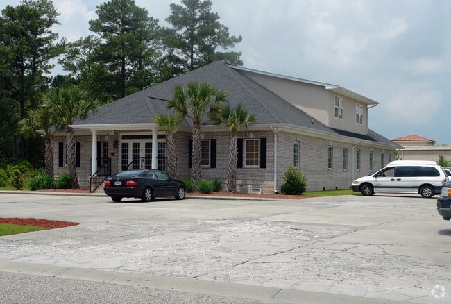
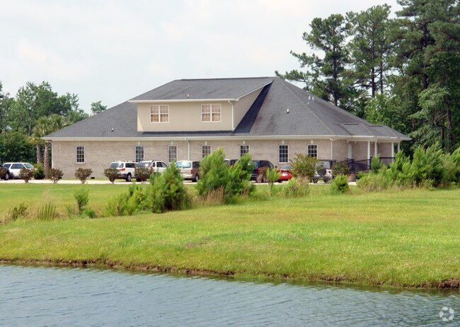
Property Detail
3012 Newcastle Loop
Myrtle Beach-Conway-North Myrtle Beach, SC
QUEENS HARBOUR PROF PK; LOT 23
45804040002
HORRY
Officebuilding
South Carolina
B and X Area of moderate flood hazard, usually the area between the limits of the 100-year and 500-year floods.
23
2025
0.76 AC
2025
Outlying Horry County
051607
Myrtle Beach/Conway
5,940 SF
NEARBY LISTINGS FOR SALE OR LEASE
DEMOGRAPHICS near 3012 Newcastle Loop
1 mile
3 mile
5 mile
2025 Total Population
5,037
55,034
110,072
2030 Population
5,760
62,996
126,044
Pop Growth 2025-2030
+ 14.35%
+ 14.47%
+ 14.51%
Average Age
50
48
48
2025 Total Households
2,253
24,551
49,327
HH Growth 2025-2030
+ 14.38%
+ 14.57%
+ 14.58%
Median Household Inc
$83,388
$76,389
$72,370
Avg Household Size
2.10
2.20
2.20
2025 Avg HH Vehicles
2.00
2.00
2.00
Median Home Value
$329,733
$322,570
$317,953
Median Year Built
2001
1998
1998
Nearby Places
Map Layers
Map Styles
 Street
 Aerial
Transit
 Traffic
 Biking
Places
Listings with unknown addresses are not visible on the map
- Restaurants
- Banks
- Shops
- Fitness
- Groceries
PUBLIC TRANSPORTATION
AIRPORT
Myrtle Beach International
Drive
Walk
Distance
Myrtle Beach International
16 min
8.8 mi
Freight Ports
Port of Wilmington
Drive
Walk
Distance
Port of Wilmington
104 min
80.9 mi
Nearby Properties
Address
Land Use
TOTAL SIZE
Lot Size
Zoning
Address
Land Use
TOTAL SIZE
Lot Size
Zoning
17,640 SF
240.91 AC
Address
Land Use
TOTAL SIZE
Lot Size
Zoning
9,190 SF
85.15 AC
Address
Land Use
TOTAL SIZE
Lot Size
Zoning
17,600 SF
69.36 AC
Address
Land Use
TOTAL SIZE
Lot Size
Zoning
19,452 SF
20.37 AC
Address
Land Use
TOTAL SIZE
Lot Size
Zoning
28,959 SF
31.56 AC
Address
Land Use
TOTAL SIZE
Lot Size
Zoning
496.81 AC
Address
Land Use
TOTAL SIZE
Lot Size
Zoning
49,002 SF
16.92 AC
Address
Land Use
TOTAL SIZE
Lot Size
Zoning
27,579 SF
25.34 AC
Address
Land Use
TOTAL SIZE
Lot Size
Zoning
8,540 SF
42.65 AC
Address
Land Use
TOTAL SIZE
Lot Size
Zoning
28,920 SF
9.21 AC
Address
Land Use
TOTAL SIZE
Lot Size
Zoning
636.81 AC
Address
Land Use
TOTAL SIZE
Lot Size
Zoning
39,275 SF
14.87 AC
Address
Land Use
TOTAL SIZE
Lot Size
Zoning
24,948 SF
14.45 AC
Address
Land Use
TOTAL SIZE
Lot Size
Zoning
194,035 SF
26.79 AC
Address
Land Use
TOTAL SIZE
Lot Size
Zoning
92,277 SF
8.84 AC
Address
Land Use
TOTAL SIZE
Lot Size
Zoning
46.79 AC
Address
Land Use
TOTAL SIZE
Lot Size
Zoning
40,089 SF
8.24 AC
Address
Land Use
TOTAL SIZE
Lot Size
Zoning
57,216 SF
2.36 AC
Address
Land Use
TOTAL SIZE
Lot Size
Zoning
132,091 SF
14.03 AC
Address
Land Use
TOTAL SIZE
Lot Size
Zoning
18,816 SF
10.17 AC
Address
Land Use
TOTAL SIZE
Lot Size
Zoning
25,083 SF
10.33 AC
Address
Land Use
TOTAL SIZE
Lot Size
Zoning
28,278 SF
50.53 AC
Address
Land Use
TOTAL SIZE
Lot Size
Zoning
42,768 SF
10.40 AC
Address
Land Use
TOTAL SIZE
Lot Size
Zoning
8,012 SF
7.40 AC
The World's #1 Commercial Real Estate Marketplace
Connect with us
© 2026 CoStar Group
The information above has been obtained from sources believed reliable. While we do not doubt its accuracy we have not verified it and make no guarantee, warranty or representation about it. It is your responsibility to independently confirm its accuracy and completeness. Any projections, opinions, assumptions, or estimates used are for example only and do not represent the current or future performance of the property. The value of this transaction to you depends on tax and other factors which should be evaluated by your tax, financial, and legal advisors. You and your advisors should conduct a careful, independent investigation of the property to determine to your satisfaction the suitability of the property for your needs.