Property Record
3012 State Route 213 E, Stone Ridge, NY 12484
NEARBY LISTINGS FOR SALE OR LEASE
-
-
View all Stone Ridge listings for sale on LoopNet.com
Property Detail
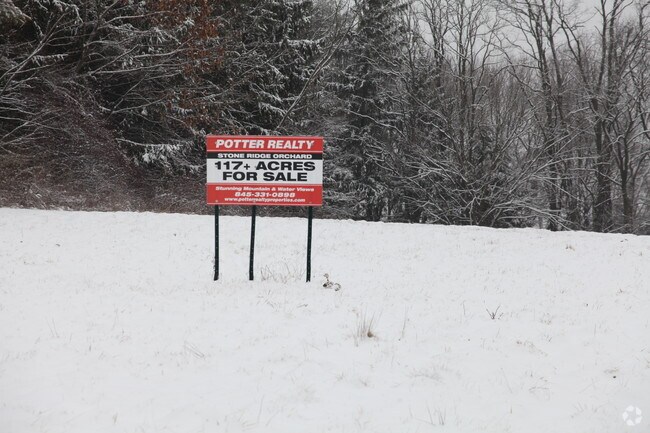
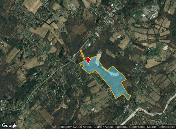
3012 State Route 213 E
3400-069.002-0005-013.000-0000
Ulster
Orchard
New York
X
13.000
36111C0585E
115.10 AC
2025
Hudson Valley Area
2024
Other Market Areas
952901
Kingston, NY
DEMOGRAPHICS near 3012 State Route 213 E
1 mile
3 mile
5 mile
2024 Total Population
582
4,432
11,601
2029 Population
583
4,408
11,535
Pop Growth 2024-2029
+ 0.17%
(0.54%)
(0.57%)
Average Age
47
47
46
2024 Total Households
261
1,956
5,047
HH Growth 2024-2029
+ 0.38%
(0.56%)
(0.61%)
Median Household Inc
$104,276
$86,306
$83,925
Avg Household Size
2.10
2.20
2.30
2024 Avg HH Vehicles
2.00
2.00
2.00
Median Home Value
$415,854
$411,917
$356,356
Median Year Built
1961
1961
1965
Nearby Places
Map Layers
Map Styles
 Street
 Aerial
Transit
 Traffic
 Biking
Places
Listings with unknown addresses are not visible on the map
- Restaurants
- Banks
- Shops
- Fitness
- Groceries
PUBLIC TRANSPORTATION
AIRPORT
New York Stewart International
Drive
Walk
Distance
New York Stewart International
55 min
36.2 mi
Freight Ports
Albany, NY Port
Drive
Walk
Distance
Albany, NY Port
76 min
61.9 mi
Nearby Properties
Address
Land Use
TOTAL SIZE
Lot Size
Zoning
Address
Land Use
TOTAL SIZE
Lot Size
Zoning
23,140 SF
87.30 AC
R1
Address
Land Use
TOTAL SIZE
Lot Size
Zoning
1,709 SF
27.40 AC
A2
Address
Land Use
TOTAL SIZE
Lot Size
Zoning
42,975 SF
35 AC
R-1
Address
Land Use
TOTAL SIZE
Lot Size
Zoning
12,000 SF
95.80 AC
A
Address
Land Use
TOTAL SIZE
Lot Size
Zoning
47,809 SF
23.80 AC
R3
Address
Land Use
TOTAL SIZE
Lot Size
Zoning
6,950 SF
82.86 AC
R1
Address
Land Use
TOTAL SIZE
Lot Size
Zoning
36,492 SF
6.25 AC
B1
Address
Land Use
TOTAL SIZE
Lot Size
Zoning
9,080 SF
42.70 AC
R1
Address
Land Use
TOTAL SIZE
Lot Size
Zoning
17,081 SF
6.94 AC
R-1
Address
Land Use
TOTAL SIZE
Lot Size
Zoning
7,615 SF
35.20 AC
B1
Address
Land Use
TOTAL SIZE
Lot Size
Zoning
2,669 SF
65.40 AC
A3
Address
Land Use
TOTAL SIZE
Lot Size
Zoning
5,370 SF
62.70 AC
R1
Address
Land Use
TOTAL SIZE
Lot Size
Zoning
4,916 SF
32.96 AC
A3
Address
Land Use
TOTAL SIZE
Lot Size
Zoning
23.70 AC
I1
Address
Land Use
TOTAL SIZE
Lot Size
Zoning
6,376 SF
92.20 AC
A3
Address
Land Use
TOTAL SIZE
Lot Size
Zoning
4,664 SF
56.43 AC
R1
Address
Land Use
TOTAL SIZE
Lot Size
Zoning
3,824 SF
140.90 AC
R1
Address
Land Use
TOTAL SIZE
Lot Size
Zoning
3,185 SF
126.50 AC
A3
Address
Land Use
TOTAL SIZE
Lot Size
Zoning
3,334 SF
26.70 AC
A3
Address
Land Use
TOTAL SIZE
Lot Size
Zoning
5,640 SF
67.30 AC
A
Address
Land Use
TOTAL SIZE
Lot Size
Zoning
3,463 SF
72.43 AC
R1
Address
Land Use
TOTAL SIZE
Lot Size
Zoning
5,976 SF
35 AC
A3
Address
Land Use
TOTAL SIZE
Lot Size
Zoning
4,764 SF
54.60 AC
R1
Address
Land Use
TOTAL SIZE
Lot Size
Zoning
960 SF
95.50 AC
AR3
Address
Land Use
TOTAL SIZE
Lot Size
Zoning
21,170 SF
18.67 AC
R-1
Address
Land Use
TOTAL SIZE
Lot Size
Zoning
3,324 SF
44 AC
R1
Address
Land Use
TOTAL SIZE
Lot Size
Zoning
4,188 SF
72.80 AC
R1
Address
Land Use
TOTAL SIZE
Lot Size
Zoning
4,768 SF
13.80 AC
A2
Address
Land Use
TOTAL SIZE
Lot Size
Zoning
4,718 SF
6.61 AC
R1
Address
Land Use
TOTAL SIZE
Lot Size
Zoning
4,990 SF
36.20 AC
R1
The World's #1 Commercial Real Estate Marketplace
Connect with us
© 2026 CoStar Group
The information above has been obtained from sources believed reliable. While we do not doubt its accuracy we have not verified it and make no guarantee, warranty or representation about it. It is your responsibility to independently confirm its accuracy and completeness. Any projections, opinions, assumptions, or estimates used are for example only and do not represent the current or future performance of the property. The value of this transaction to you depends on tax and other factors which should be evaluated by your tax, financial, and legal advisors. You and your advisors should conduct a careful, independent investigation of the property to determine to your satisfaction the suitability of the property for your needs.