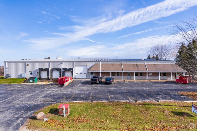
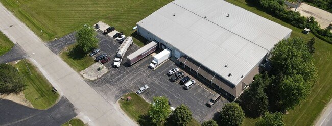
Property Record
3015 E Progress Dr, West Bend, WI 53095


Property Detail
3015 E Progress Dr
Milwaukee-Waukesha, WI
LOT 1 CSM 4633 DOC 1555136
1119-254-0021
WASHINGTON
Industrialgeneral
Wisconsin
B and X Area of moderate flood hazard, usually the area between the limits of the 100-year and 500-year floods.
1
2025
3.64 AC
2025
North Washington
420200
Milwaukee/Madison
NEARBY LISTINGS FOR SALE OR LEASE
-
-
View all West Bend listings for lease on LoopNet.com
DEMOGRAPHICS near 3015 E Progress Dr
1 mile
3 mile
5 mile
2025 Total Population
1,324
19,161
49,324
2030 Population
1,333
19,380
49,966
Pop Growth 2025-2030
+ 0.68%
+ 1.14%
+ 1.30%
Average Age
43
43
43
2025 Total Households
591
7,941
21,015
HH Growth 2025-2030
+ 0.51%
+ 1.18%
+ 1.32%
Median Household Inc
$82,825
$82,268
$83,525
Avg Household Size
2.20
2.30
2.30
2025 Avg HH Vehicles
2.00
2.00
2.00
Median Home Value
$337,000
$317,372
$303,557
Median Year Built
1990
1976
1981
Nearby Places
Map Layers
Map Styles
 Street
 Aerial
Transit
 Traffic
 Biking
Places
Listings with unknown addresses are not visible on the map
- Restaurants
- Banks
- Shops
- Fitness
- Groceries
PUBLIC TRANSPORTATION
AIRPORT
General Mitchell International
Drive
Walk
Distance
General Mitchell International
58 min
42.0 mi
Freight Ports
Port Milwaukee
Drive
Walk
Distance
Port Milwaukee
52 min
38.2 mi
SALE & LEASE HISTORY
LISTING DATE
SALE/LEASE

Jul 20, 2021
For Lease
Jul 20, 2021
For Sale
Nearby Properties
Address
Land Use
TOTAL SIZE
Lot Size
Zoning
Address
Land Use
TOTAL SIZE
Lot Size
Zoning
141,874 SF
116.53 AC
Address
Land Use
TOTAL SIZE
Lot Size
Zoning
5,600 SF
10.11 AC
Address
Land Use
TOTAL SIZE
Lot Size
Zoning
Address
Land Use
TOTAL SIZE
Lot Size
Zoning
195,055 SF
20.57 AC
Address
Land Use
TOTAL SIZE
Lot Size
Zoning
16.43 AC
Address
Land Use
TOTAL SIZE
Lot Size
Zoning
9.05 AC
Address
Land Use
TOTAL SIZE
Lot Size
Zoning
18.22 AC
Address
Land Use
TOTAL SIZE
Lot Size
Zoning
20.92 AC
Address
Land Use
TOTAL SIZE
Lot Size
Zoning
4,140 SF
29.62 AC
Address
Land Use
TOTAL SIZE
Lot Size
Zoning
6.85 AC
Address
Land Use
TOTAL SIZE
Lot Size
Zoning
139,945 SF
4.95 AC
Address
Land Use
TOTAL SIZE
Lot Size
Zoning
80,634 SF
22.21 AC
Address
Land Use
TOTAL SIZE
Lot Size
Zoning
30,564 SF
31.65 AC
Address
Land Use
TOTAL SIZE
Lot Size
Zoning
26.21 AC
Address
Land Use
TOTAL SIZE
Lot Size
Zoning
7.70 AC
Address
Land Use
TOTAL SIZE
Lot Size
Zoning
30,046 SF
3.91 AC
Address
Land Use
TOTAL SIZE
Lot Size
Zoning
8.29 AC
Address
Land Use
TOTAL SIZE
Lot Size
Zoning
102,366 SF
9.35 AC
Address
Land Use
TOTAL SIZE
Lot Size
Zoning
12.67 AC
Address
Land Use
TOTAL SIZE
Lot Size
Zoning
3.89 AC
Address
Land Use
TOTAL SIZE
Lot Size
Zoning
Address
Land Use
TOTAL SIZE
Lot Size
Zoning
200,000 SF
16.18 AC
Address
Land Use
TOTAL SIZE
Lot Size
Zoning
141,575 SF
4.44 AC
Address
Land Use
TOTAL SIZE
Lot Size
Zoning
12.71 AC
Address
Land Use
TOTAL SIZE
Lot Size
Zoning
50,096 SF
8.91 AC
Address
Land Use
TOTAL SIZE
Lot Size
Zoning
18,400 SF
10.85 AC
Address
Land Use
TOTAL SIZE
Lot Size
Zoning
27.12 AC
Address
Land Use
TOTAL SIZE
Lot Size
Zoning
9.01 AC
Address
Land Use
TOTAL SIZE
Lot Size
Zoning
4.41 AC
Address
Land Use
TOTAL SIZE
Lot Size
Zoning
11.60 AC
The World's #1 Commercial Real Estate Marketplace
Connect with us
© 2026 CoStar Group
The information above has been obtained from sources believed reliable. While we do not doubt its accuracy we have not verified it and make no guarantee, warranty or representation about it. It is your responsibility to independently confirm its accuracy and completeness. Any projections, opinions, assumptions, or estimates used are for example only and do not represent the current or future performance of the property. The value of this transaction to you depends on tax and other factors which should be evaluated by your tax, financial, and legal advisors. You and your advisors should conduct a careful, independent investigation of the property to determine to your satisfaction the suitability of the property for your needs.