Property Record
3015 Flagstone St, Greensboro, NC 27406

Save to a Folder
{{folder.Name}}
{{folder.ListingIds.length}} Properties
{{folder.ListingIds.length}} Property
Create a New Folder
Property Detail
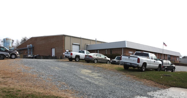
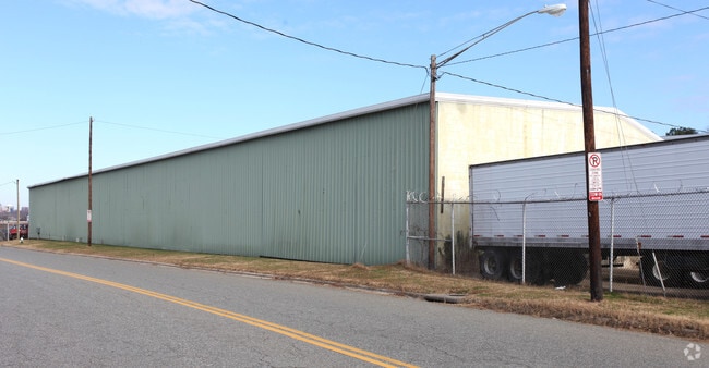
3015 Flagstone St
0051850
13.75 AC INTERSTATE IND
Industrialgeneral
GUILFORD
HI
North Carolina
B and X Area of moderate flood hazard, usually the area between the limits of the 100-year and 500-year floods.
23
2024
13.75 AC
2025
South Greensboro
012804
Greensboro/Winston-Salem
67,150 SF
Greensboro-High Point, NC
NEARBY LISTINGS FOR SALE OR LEASE
DEMOGRAPHICS near 3015 Flagstone St
1 mile
3 mile
5 mile
2025 Total Population
4,165
62,028
148,662
2030 Population
4,251
64,044
153,556
Pop Growth 2025-2030
+ 2.06%
+ 3.25%
+ 3.29%
Average Age
40
36
36
2025 Total Households
1,830
24,197
56,452
HH Growth 2025-2030
+ 2.35%
+ 3.52%
+ 3.61%
Median Household Inc
$57,170
$48,846
$51,829
Avg Household Size
2.20
2.30
2.30
2025 Avg HH Vehicles
2.00
2.00
2.00
Median Home Value
$187,252
$175,240
$206,169
Median Year Built
1991
1978
1976
Nearby Places
Map Layers
Map Styles
 Street
 Aerial
Layers
 Traffic
 Biking
Places
Listings with unknown addresses are not visible on the map
- Restaurants
- Banks
- Shops
- Fitness
- Groceries
PUBLIC TRANSPORTATION
COMMUTER RAIL
Greensboro Station (Piedmont - North Carolina by Train (NC Train))
Drive
Walk
Distance
Greensboro Station (Piedmont - North Carolina by Train (NC Train))
7 min
3.6 mi
AIRPORT
Piedmont Triad International
Drive
Walk
Distance
Piedmont Triad International
25 min
16.2 mi
Nearby Properties
Address
Land Use
TOTAL SIZE
Lot Size
Zoning
Address
Land Use
TOTAL SIZE
Lot Size
Zoning
570,402 SF
33.42 AC
RM-18
Address
Land Use
TOTAL SIZE
Lot Size
Zoning
313,033 SF
71.38 AC
O
Address
Land Use
TOTAL SIZE
Lot Size
Zoning
446,318 SF
125.67 AC
LI
Address
Land Use
TOTAL SIZE
Lot Size
Zoning
412,479 SF
19.68 AC
RM-26
Address
Land Use
TOTAL SIZE
Lot Size
Zoning
291,464 SF
17.51 AC
PI
Address
Land Use
TOTAL SIZE
Lot Size
Zoning
252,351 SF
9.48 AC
RM-18
Address
Land Use
TOTAL SIZE
Lot Size
Zoning
300,901 SF
20.39 AC
RM-18
Address
Land Use
TOTAL SIZE
Lot Size
Zoning
236,374 SF
7.69 AC
CB
Address
Land Use
TOTAL SIZE
Lot Size
Zoning
231,863 SF
7.96 AC
PUD
Address
Land Use
TOTAL SIZE
Lot Size
Zoning
345,087 SF
15.73 AC
PI
Address
Land Use
TOTAL SIZE
Lot Size
Zoning
310,758 SF
63.58 AC
PI
Address
Land Use
TOTAL SIZE
Lot Size
Zoning
280,200 SF
19.28 AC
RM-12
Address
Land Use
TOTAL SIZE
Lot Size
Zoning
242,730 SF
13.70 AC
PUD
Address
Land Use
TOTAL SIZE
Lot Size
Zoning
582,543 SF
47.07 AC
C-M
Address
Land Use
TOTAL SIZE
Lot Size
Zoning
104,984 SF
1.97 AC
C-M
Address
Land Use
TOTAL SIZE
Lot Size
Zoning
82,450 SF
117.82 AC
R-5
Address
Land Use
TOTAL SIZE
Lot Size
Zoning
109,706 SF
1.56 AC
CB
Address
Land Use
TOTAL SIZE
Lot Size
Zoning
104,984 SF
3.18 AC
C-M
Address
Land Use
TOTAL SIZE
Lot Size
Zoning
336,760 SF
55.13 AC
LI
Address
Land Use
TOTAL SIZE
Lot Size
Zoning
201,999 SF
22.18 AC
C-H
Address
Land Use
TOTAL SIZE
Lot Size
Zoning
188,976 SF
41.46 AC
R-5
Address
Land Use
TOTAL SIZE
Lot Size
Zoning
83,667 SF
1.04 AC
CB
Address
Land Use
TOTAL SIZE
Lot Size
Zoning
88,808 SF
2.03 AC
CB
Address
Land Use
TOTAL SIZE
Lot Size
Zoning
141,210 SF
4.42 AC
PUD
Address
Land Use
TOTAL SIZE
Lot Size
Zoning
84,720 SF
1.02 AC
CB
Address
Land Use
TOTAL SIZE
Lot Size
Zoning
168,572 SF
11.94 AC
LI
Address
Land Use
TOTAL SIZE
Lot Size
Zoning
107,525 SF
1.68 AC
RM-12
Address
Land Use
TOTAL SIZE
Lot Size
Zoning
49,625 SF
6.25 AC
C-M
Address
Land Use
TOTAL SIZE
Lot Size
Zoning
223,912 SF
23.25 AC
O
Address
Land Use
TOTAL SIZE
Lot Size
Zoning
262,937 SF
20.40 AC
RM-18
The World's #1 Commercial Real Estate Marketplace
Connect with us
© 2026 CoStar Group
The information above has been obtained from sources believed reliable. While we do not doubt its accuracy we have not verified it and make no guarantee, warranty or representation about it. It is your responsibility to independently confirm its accuracy and completeness. Any projections, opinions, assumptions, or estimates used are for example only and do not represent the current or future performance of the property. The value of this transaction to you depends on tax and other factors which should be evaluated by your tax, financial, and legal advisors. You and your advisors should conduct a careful, independent investigation of the property to determine to your satisfaction the suitability of the property for your needs.