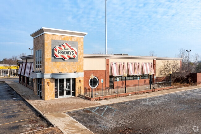
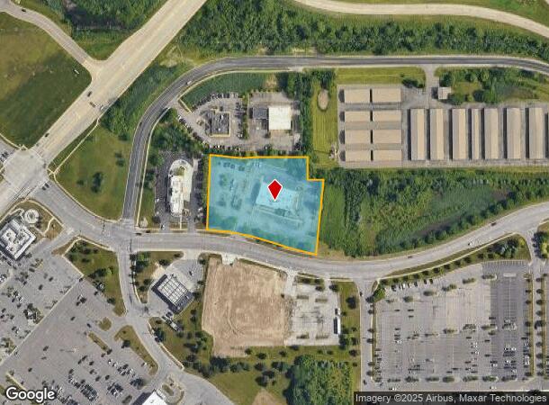
Property Record
3015 Lohr Rd, Ann Arbor, MI 48108
NEARBY LISTINGS FOR SALE OR LEASE
Property Detail
3015 Lohr Rd
12-07-115-010
Washtenaw County Condominium Subdivision
Commercialnec
ASSR REQUEST ****FROM 1207115005 01/27/97 ****FROM 1207115006 01/27/97 ****FROM 1207100002 11/01/93 ****FROM 1207100025
X
Washtenaw
26161C0382E
Michigan
2025
1.71 AC
2025
Washtenaw W of 23
414700
Detroit
6,988 SF
Ann Arbor, MI
DEMOGRAPHICS near 3015 Lohr Rd
1 Mile
3 Mile
5 Mile
2024 Total Population
10,935
79,154
150,526
2029 Population
10,965
78,348
148,908
Pop Growth 2024-2029
+ 0.27%
(1.02%)
(1.07%)
Average Age
42
36
37
2024 Total Households
5,005
32,992
61,694
HH Growth 2024-2029
(0.02%)
(0.96%)
(1.07%)
Median Household Inc
$107,176
$79,592
$82,112
Avg Household Size
2.10
2.20
2.20
2024 Avg HH Vehicles
2.00
2.00
2.00
Median Home Value
$433,055
$433,649
$412,806
Median Year Built
1992
1976
1976
Nearby Places
Map Layers
Map Styles
 Street
 Aerial
- Restaurants
- Banks
- Shops
- Fitness
- Groceries
PUBLIC TRANSPORTATION
COMMUTER RAIL
DRIVE
WALK
Distance
10 min
4.0 mi
AIRPORT
Detroit Metro Wayne County
DRIVE
WALK
Distance
Detroit Metro Wayne County
35 min
26.7 mi
SALE & LEASE HISTORY
LISTING DATE
SALE/LEASE

Oct 23, 2020
For Lease
Dec 09, 2021
For Sale
Nearby Properties
Address
Land Use
TOTAL SIZE
Lot Size
Zoning
Address
Land Use
TOTAL SIZE
Lot Size
Zoning
235,070 SF
0.80 AC
D1
Address
Land Use
TOTAL SIZE
Lot Size
Zoning
212,047 SF
1.15 AC
D2
Address
Land Use
TOTAL SIZE
Lot Size
Zoning
268,612 SF
0.74 AC
D1
Address
Land Use
TOTAL SIZE
Lot Size
Zoning
186,029 SF
2.06 AC
D2
Address
Land Use
TOTAL SIZE
Lot Size
Zoning
Address
Land Use
TOTAL SIZE
Lot Size
Zoning
211,670 SF
0.54 AC
D1
Address
Land Use
TOTAL SIZE
Lot Size
Zoning
222,126 SF
0.52 AC
D1
Address
Land Use
TOTAL SIZE
Lot Size
Zoning
189,221 SF
0.58 AC
D1
Address
Land Use
TOTAL SIZE
Lot Size
Zoning
315,108 SF
6.57 AC
C1B
Address
Land Use
TOTAL SIZE
Lot Size
Zoning
173,885 SF
0.45 AC
D1
Address
Land Use
TOTAL SIZE
Lot Size
Zoning
334,077 SF
20.41 AC
R4B
Address
Land Use
TOTAL SIZE
Lot Size
Zoning
140,840 SF
0.50 AC
D1
Address
Land Use
TOTAL SIZE
Lot Size
Zoning
357,978 SF
19.32 AC
R4B
Address
Land Use
TOTAL SIZE
Lot Size
Zoning
140,670 SF
1.63 AC
C2B
Address
Land Use
TOTAL SIZE
Lot Size
Zoning
133,830 SF
0.59 AC
D1
Address
Land Use
TOTAL SIZE
Lot Size
Zoning
177,763 SF
0.91 AC
D2
Address
Land Use
TOTAL SIZE
Lot Size
Zoning
303,524 SF
19.40 AC
R4B
Address
Land Use
TOTAL SIZE
Lot Size
Zoning
99,982 SF
0.35 AC
D1
Address
Land Use
TOTAL SIZE
Lot Size
Zoning
140,039 SF
Address
Land Use
TOTAL SIZE
Lot Size
Zoning
271,521 SF
15.11 AC
Address
Land Use
TOTAL SIZE
Lot Size
Zoning
127,076 SF
0.39 AC
D1
Address
Land Use
TOTAL SIZE
Lot Size
Zoning
333,275 SF
0.65 AC
D1
Address
Land Use
TOTAL SIZE
Lot Size
Zoning
214,559 SF
16.18 AC
PUD
Address
Land Use
TOTAL SIZE
Lot Size
Zoning
268,002 SF
18.34 AC
Address
Land Use
TOTAL SIZE
Lot Size
Zoning
125,073 SF
0.26 AC
D1
Address
Land Use
TOTAL SIZE
Lot Size
Zoning
137,874 SF
0.55 AC
PUD
Address
Land Use
TOTAL SIZE
Lot Size
Zoning
234,076 SF
24.18 AC
R4A
Address
Land Use
TOTAL SIZE
Lot Size
Zoning
1.19 AC
R4C
Address
Land Use
TOTAL SIZE
Lot Size
Zoning
116,650 SF
0.32 AC
D1
Address
Land Use
TOTAL SIZE
Lot Size
Zoning
111,435 SF
21.38 AC
R4B
The World's #1 Commercial Real Estate Marketplace
Connect with us
© 2025 CoStar Group
The information above has been obtained from sources believed reliable. While we do not doubt its accuracy we have not verified it and make no guarantee, warranty or representation about it. It is your responsibility to independently confirm its accuracy and completeness. Any projections, opinions, assumptions, or estimates used are for example only and do not represent the current or future performance of the property. The value of this transaction to you depends on tax and other factors which should be evaluated by your tax, financial, and legal advisors. You and your advisors should conduct a careful, independent investigation of the property to determine to your satisfaction the suitability of the property for your needs.