Property Record
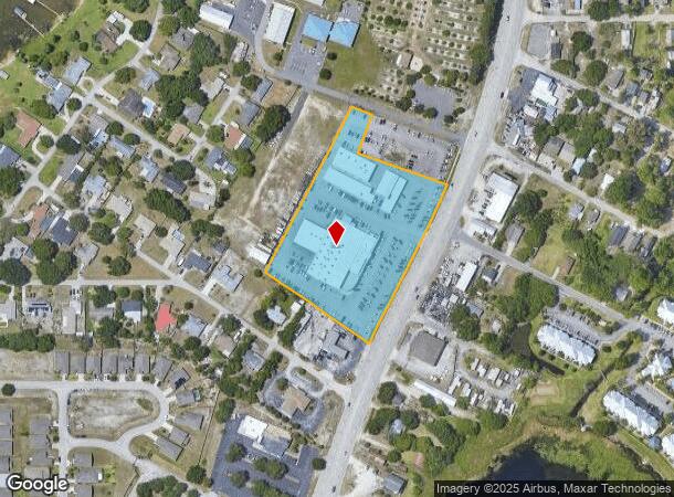
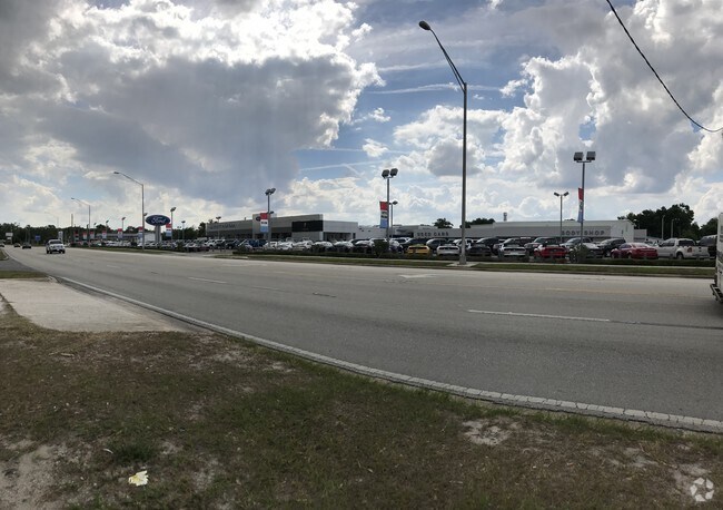
3015 N Us Highway 17 Rd, Winter Haven, FL 33881

NEARBY LISTINGS FOR SALE OR LEASE
Property Detail
3015 N Us Highway 17 Rd
26-28-17-000000-013060
Lakeside Memorial Pk 2Nd Repla
Vehiclerentalsvehiclesales
BEG NE COR OF REPLAT OF PINE TERRACE RUN N 55 DEG 33 MIN W 396.13 FT N 28 DEG 09 MIN 48 SEC E 582.95 FT S 69 DEG 57 MIN E 65.78 FT S 20 DEG 03 MIN W 130 FT S 69 DEG 57 MIN E 296.50 FT TO R/W US 17 SWLY ALONG CURVE A CHORD DISTANCE OF 230.13 FT S 27 D
X
Polk
12105C0365G
Florida
2024
4.67 AC
2025
Polk County
013602
Tampa/St Petersburg
50,210 SF
Lakeland-Winter Haven, FL
DEMOGRAPHICS near 3015 N Us Highway 17 Rd
1 Mile
3 Mile
5 Mile
2024 Total Population
5,964
49,209
109,854
2029 Population
7,260
59,363
132,633
Pop Growth 2024-2029
+ 21.73%
+ 20.63%
+ 20.74%
Average Age
43
41
41
2024 Total Households
2,544
19,634
42,968
HH Growth 2024-2029
+ 21.58%
+ 20.59%
+ 20.66%
Median Household Inc
$46,052
$44,251
$52,797
Avg Household Size
2.30
2.40
2.50
2024 Avg HH Vehicles
1.00
2.00
2.00
Median Home Value
$199,277
$170,752
$187,622
Median Year Built
1982
1976
1982
Nearby Places
Map Layers
Map Styles
 Street
 Aerial
- Restaurants
- Banks
- Shops
- Fitness
- Groceries
PUBLIC TRANSPORTATION
COMMUTER RAIL
Winter Haven (Silver Meteor - Amtrak, Silver Star - Amtrak)
DRIVE
WALK
Distance
Winter Haven (Silver Meteor - Amtrak, Silver Star - Amtrak)
7 min
3.7 mi
Freight Ports
Port of Tampa Bay
DRIVE
WALK
Distance
Port of Tampa Bay
70 min
48.7 mi
Nearby Properties
Address
Land Use
TOTAL SIZE
Lot Size
Zoning
Address
Land Use
TOTAL SIZE
Lot Size
Zoning
728,846 SF
28.07 AC
Address
Land Use
TOTAL SIZE
Lot Size
Zoning
250,170 SF
24.21 AC
Address
Land Use
TOTAL SIZE
Lot Size
Zoning
386,137 SF
39.91 AC
Address
Land Use
TOTAL SIZE
Lot Size
Zoning
282,400 SF
19.59 AC
XX
Address
Land Use
TOTAL SIZE
Lot Size
Zoning
267,076 SF
31.67 AC
Address
Land Use
TOTAL SIZE
Lot Size
Zoning
75,936 SF
0.76 AC
R3
Address
Land Use
TOTAL SIZE
Lot Size
Zoning
200,200 SF
10.29 AC
Address
Land Use
TOTAL SIZE
Lot Size
Zoning
148,390 SF
10.42 AC
R1
Address
Land Use
TOTAL SIZE
Lot Size
Zoning
277,680 SF
43.76 AC
R1C
Address
Land Use
TOTAL SIZE
Lot Size
Zoning
188,403 SF
27.79 AC
BT
Address
Land Use
TOTAL SIZE
Lot Size
Zoning
123,540 SF
5.89 AC
Address
Land Use
TOTAL SIZE
Lot Size
Zoning
259,700 SF
51.97 AC
Address
Land Use
TOTAL SIZE
Lot Size
Zoning
135,885 SF
10.12 AC
Address
Land Use
TOTAL SIZE
Lot Size
Zoning
102,307 SF
1.79 AC
RP
Address
Land Use
TOTAL SIZE
Lot Size
Zoning
77,388 SF
5.37 AC
BT
Address
Land Use
TOTAL SIZE
Lot Size
Zoning
185,895 SF
16.16 AC
BR
Address
Land Use
TOTAL SIZE
Lot Size
Zoning
173,328 SF
37.45 AC
C3
Address
Land Use
TOTAL SIZE
Lot Size
Zoning
96,370 SF
5.08 AC
Address
Land Use
TOTAL SIZE
Lot Size
Zoning
129,567 SF
11.72 AC
C3
Address
Land Use
TOTAL SIZE
Lot Size
Zoning
277,729 SF
423.34 AC
Address
Land Use
TOTAL SIZE
Lot Size
Zoning
90,200 SF
1.93 AC
RP
Address
Land Use
TOTAL SIZE
Lot Size
Zoning
122,752 SF
1.68 AC
Address
Land Use
TOTAL SIZE
Lot Size
Zoning
76,664 SF
18.64 AC
RP
Address
Land Use
TOTAL SIZE
Lot Size
Zoning
106,524 SF
11.32 AC
Address
Land Use
TOTAL SIZE
Lot Size
Zoning
77,824 SF
12.78 AC
Address
Land Use
TOTAL SIZE
Lot Size
Zoning
73,576 SF
7.75 AC
R3
Address
Land Use
TOTAL SIZE
Lot Size
Zoning
75,894 SF
1.67 AC
BR
Address
Land Use
TOTAL SIZE
Lot Size
Zoning
172,254 SF
1.81 AC
BR
Address
Land Use
TOTAL SIZE
Lot Size
Zoning
138,854 SF
13.39 AC
Address
Land Use
TOTAL SIZE
Lot Size
Zoning
106,376 SF
18.36 AC
The World's #1 Commercial Real Estate Marketplace
Connect with us
© 2026 CoStar Group
The information above has been obtained from sources believed reliable. While we do not doubt its accuracy we have not verified it and make no guarantee, warranty or representation about it. It is your responsibility to independently confirm its accuracy and completeness. Any projections, opinions, assumptions, or estimates used are for example only and do not represent the current or future performance of the property. The value of this transaction to you depends on tax and other factors which should be evaluated by your tax, financial, and legal advisors. You and your advisors should conduct a careful, independent investigation of the property to determine to your satisfaction the suitability of the property for your needs.