Property Record
3015 S Nc Highway 87, Graham, NC 27253
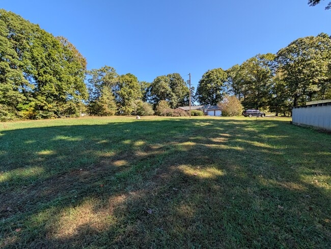
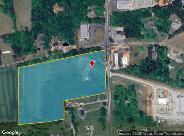
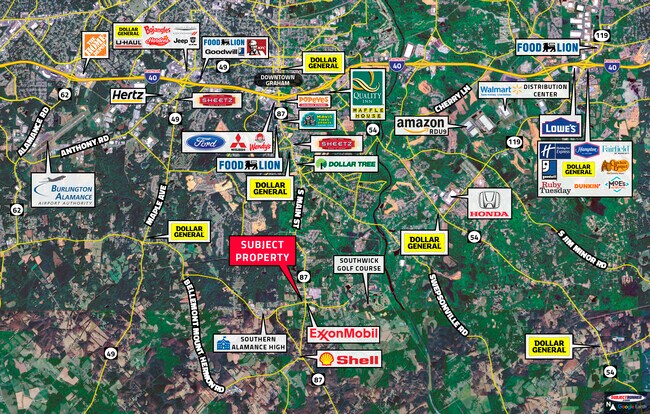

This Property Is For Sale
NEARBY LISTINGS FOR SALE OR LEASE
Property Detail
3015 S Nc Highway 87
Burlington, NC
Alamance
142886
North Carolina
Sfr
4.50 AC
X
S Central Alamance County
3710888200K
Greensboro/Winston-Salem
1,257 SF
DEMOGRAPHICS near 3015 S Nc Highway 87
1 Mile
3 Mile
5 Mile
2024 Total Population
1,550
12,029
37,236
2029 Population
1,647
12,767
39,615
Pop Growth 2024-2029
+ 6.26%
+ 6.14%
+ 6.39%
Average Age
42
43
41
2024 Total Households
627
4,886
15,262
HH Growth 2024-2029
+ 6.38%
+ 6.28%
+ 6.55%
Median Household Inc
$81,171
$79,494
$69,665
Avg Household Size
2.50
2.40
2.40
2024 Avg HH Vehicles
2.00
2.00
2.00
Median Home Value
$291,723
$299,232
$281,642
Median Year Built
1993
1992
1991
Nearby Places
Map Layers
Map Styles
 Street
 Aerial
- Restaurants
- Banks
- Shops
- Fitness
- Groceries
PUBLIC TRANSPORTATION
COMMUTER RAIL
Burlington Station (Piedmont - North Carolina by Train (NC Train))
DRIVE
WALK
Distance
Burlington Station (Piedmont - North Carolina by Train (NC Train))
14 min
7.6 mi
AIRPORT
Piedmont Triad International
DRIVE
WALK
Distance
Piedmont Triad International
55 min
41.2 mi
Raleigh-Durham International
DRIVE
WALK
Distance
Raleigh-Durham International
61 min
47.2 mi
Nearby Properties
Address
Land Use
TOTAL SIZE
Lot Size
Zoning
Address
Land Use
TOTAL SIZE
Lot Size
Zoning
5,246 SF
89.50 AC
Address
Land Use
TOTAL SIZE
Lot Size
Zoning
20,000 SF
8.48 AC
B 2
Address
Land Use
TOTAL SIZE
Lot Size
Zoning
3,600 SF
6.80 AC
R 18
Address
Land Use
TOTAL SIZE
Lot Size
Zoning
500 SF
59.87 AC
Address
Land Use
TOTAL SIZE
Lot Size
Zoning
4,572 SF
189.40 AC
Address
Land Use
TOTAL SIZE
Lot Size
Zoning
10,068 SF
10.57 AC
R 18
Address
Land Use
TOTAL SIZE
Lot Size
Zoning
164,942 SF
17.81 AC
Address
Land Use
TOTAL SIZE
Lot Size
Zoning
13,464 SF
13.57 AC
Address
Land Use
TOTAL SIZE
Lot Size
Zoning
9,660 SF
6.50 AC
Address
Land Use
TOTAL SIZE
Lot Size
Zoning
10,068 SF
18.65 AC
R 18
Address
Land Use
TOTAL SIZE
Lot Size
Zoning
40.01 AC
R G
Address
Land Use
TOTAL SIZE
Lot Size
Zoning
6,375 SF
2.13 AC
B 2
Address
Land Use
TOTAL SIZE
Lot Size
Zoning
9,984 SF
0.85 AC
Address
Land Use
TOTAL SIZE
Lot Size
Zoning
10,488 SF
1.09 AC
R 12
Address
Land Use
TOTAL SIZE
Lot Size
Zoning
9,217 SF
1.20 AC
B2
Address
Land Use
TOTAL SIZE
Lot Size
Zoning
9,100 SF
1.86 AC
Address
Land Use
TOTAL SIZE
Lot Size
Zoning
104.62 AC
Address
Land Use
TOTAL SIZE
Lot Size
Zoning
1,632 SF
1.60 AC
Address
Land Use
TOTAL SIZE
Lot Size
Zoning
11,547 SF
11.44 AC
Address
Land Use
TOTAL SIZE
Lot Size
Zoning
2,146 SF
1.66 AC
Address
Land Use
TOTAL SIZE
Lot Size
Zoning
6,320 SF
1.91 AC
Address
Land Use
TOTAL SIZE
Lot Size
Zoning
12,000 SF
13.02 AC
Address
Land Use
TOTAL SIZE
Lot Size
Zoning
840 SF
233.66 AC
Address
Land Use
TOTAL SIZE
Lot Size
Zoning
5,151 SF
1.20 AC
B 2
Address
Land Use
TOTAL SIZE
Lot Size
Zoning
9,180 SF
0.51 AC
Address
Land Use
TOTAL SIZE
Lot Size
Zoning
59.07 AC
R12
Address
Land Use
TOTAL SIZE
Lot Size
Zoning
2,448 SF
0.90 AC
Address
Land Use
TOTAL SIZE
Lot Size
Zoning
21,882 SF
1.50 AC
B2
Address
Land Use
TOTAL SIZE
Lot Size
Zoning
51.86 AC
R 18
Address
Land Use
TOTAL SIZE
Lot Size
Zoning
4,634 SF
1.73 AC
B2
The World's #1 Commercial Real Estate Marketplace
Connect with us
© 2025 CoStar Group
The information above has been obtained from sources believed reliable. While we do not doubt its accuracy we have not verified it and make no guarantee, warranty or representation about it. It is your responsibility to independently confirm its accuracy and completeness. Any projections, opinions, assumptions, or estimates used are for example only and do not represent the current or future performance of the property. The value of this transaction to you depends on tax and other factors which should be evaluated by your tax, financial, and legal advisors. You and your advisors should conduct a careful, independent investigation of the property to determine to your satisfaction the suitability of the property for your needs.