Property Record
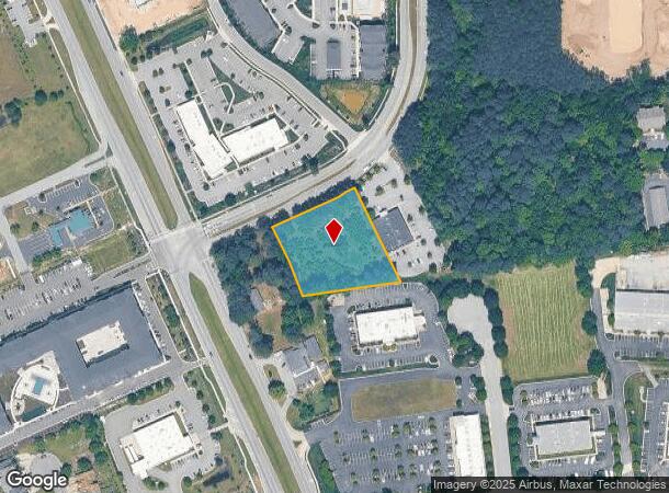
1001 Hillpoint Blvd S, Suffolk, VA 23434

Current Lease Availabilities
NEARBY LISTINGS FOR SALE OR LEASE
Property Detail
1001 Hillpoint Blvd S
Virginia Beach-Norfolk-Newport News, VA-NC
Nrgc Subdivision Phase 1
254001555
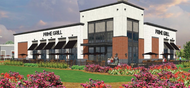
UNIT A,HILLPOINT COMMERCIAL CONDO
Residentialacreage
Suffolk City
X
Virginia
51093C0300E
1.61 AC
2025
Suffolk
2024
Hampton Roads
065200
DEMOGRAPHICS near 1001 Hillpoint Blvd S
1 Mile
3 Mile
5 Mile
2024 Total Population
8,105
22,206
52,082
2029 Population
9,065
24,741
57,813
Pop Growth 2024-2029
+ 11.84%
+ 11.42%
+ 11.00%
Average Age
36
39
39
2024 Total Households
2,993
7,933
19,520
HH Growth 2024-2029
+ 12.23%
+ 11.98%
+ 11.34%
Median Household Inc
$91,255
$91,133
$69,968
Avg Household Size
2.70
2.60
2.60
2024 Avg HH Vehicles
2.00
2.00
2.00
Median Home Value
$260,385
$286,298
$267,524
Median Year Built
2005
2002
1990
Nearby Places
- Restaurants
- Banks
- Shops
- Fitness
- Groceries
PUBLIC TRANSPORTATION
AIRPORT
Norfolk International
DRIVE
WALK
Distance
Norfolk International
41 min
27.6 mi
Newport News/Williamsburg International
DRIVE
WALK
Distance
Newport News/Williamsburg International
47 min
31.3 mi
Freight Ports
Virginia Port Authority - Portsmouth
DRIVE
WALK
Distance
Virginia Port Authority - Portsmouth
31 min
20.5 mi
Nearby Properties
Address
Land Use
TOTAL SIZE
Lot Size
Zoning
Address
Land Use
TOTAL SIZE
Lot Size
Zoning
10,850 SF
51.12 AC
GENERAL CO
Address
Land Use
TOTAL SIZE
Lot Size
Zoning
41,368 SF
58.33 AC
HEAVY INDU
Address
Land Use
TOTAL SIZE
Lot Size
Zoning
5,617 SF
16.96 AC
MIXED USE
Address
Land Use
TOTAL SIZE
Lot Size
Zoning
56,994 SF
12.84 AC
PLANNED DE
Address
Land Use
TOTAL SIZE
Lot Size
Zoning
49,292 SF
9 AC
GENERAL CO
Address
Land Use
TOTAL SIZE
Lot Size
Zoning
388,200 SF
27.99 AC
LIGHT INDU
Address
Land Use
TOTAL SIZE
Lot Size
Zoning
275,292 SF
79.88 AC
COMMERCE P
Address
Land Use
TOTAL SIZE
Lot Size
Zoning
1,721 SF
169.84 AC
RESIDENTIA
Address
Land Use
TOTAL SIZE
Lot Size
Zoning
13.21 AC
OFFICE-INS
Address
Land Use
TOTAL SIZE
Lot Size
Zoning
19.66 AC
RES LOW-ME
Address
Land Use
TOTAL SIZE
Lot Size
Zoning
203,000 SF
31.65 AC
HEAVY INDU
Address
Land Use
TOTAL SIZE
Lot Size
Zoning
4,928 SF
20.79 AC
GENERAL CO
Address
Land Use
TOTAL SIZE
Lot Size
Zoning
19,100 SF
9.84 AC
HEAVY INDU
Address
Land Use
TOTAL SIZE
Lot Size
Zoning
97,713 SF
15.22 AC
PLANNED DE
Address
Land Use
TOTAL SIZE
Lot Size
Zoning
9.02 AC
PLANNED DE
Address
Land Use
TOTAL SIZE
Lot Size
Zoning
86.84 AC
GENERAL CO
Address
Land Use
TOTAL SIZE
Lot Size
Zoning
131,990 SF
31.40 AC
RURAL RESI
Address
Land Use
TOTAL SIZE
Lot Size
Zoning
12,457 SF
27.01 AC
GENERAL CO
Address
Land Use
TOTAL SIZE
Lot Size
Zoning
24,371 SF
1,757.56 AC
CONSERVATI
Address
Land Use
TOTAL SIZE
Lot Size
Zoning
83,064 SF
26.61 AC
RES LOW-ME
Address
Land Use
TOTAL SIZE
Lot Size
Zoning
37.97 AC
PLANNED DE
Address
Land Use
TOTAL SIZE
Lot Size
Zoning
27,857 SF
20.26 AC
HEAVY INDU
Address
Land Use
TOTAL SIZE
Lot Size
Zoning
14,361 SF
93.92 AC
OFFICE-INS
Address
Land Use
TOTAL SIZE
Lot Size
Zoning
5,000 SF
5.92 AC
GENERAL CO
Address
Land Use
TOTAL SIZE
Lot Size
Zoning
15,200 SF
12.92 AC
HEAVY INDU
Address
Land Use
TOTAL SIZE
Lot Size
Zoning
4,458 SF
40.56 AC
GENERAL CO
The World's #1 Commercial Real Estate Marketplace
Connect with us
© 2025 CoStar Group
The information above has been obtained from sources believed reliable. While we do not doubt its accuracy we have not verified it and make no guarantee, warranty or representation about it. It is your responsibility to independently confirm its accuracy and completeness. Any projections, opinions, assumptions, or estimates used are for example only and do not represent the current or future performance of the property. The value of this transaction to you depends on tax and other factors which should be evaluated by your tax, financial, and legal advisors. You and your advisors should conduct a careful, independent investigation of the property to determine to your satisfaction the suitability of the property for your needs.