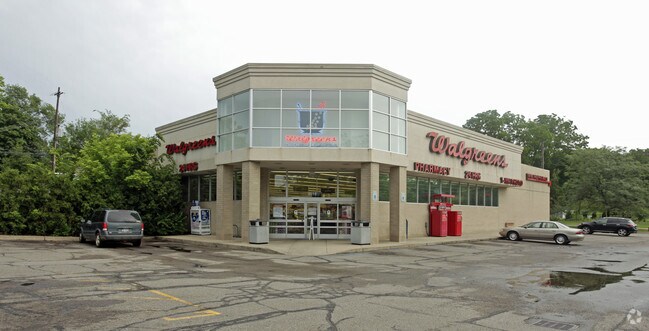
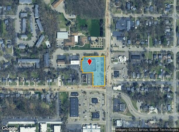
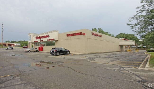
Property Record
3016 S Westnedge Ave, Kalamazoo, MI 49008
NEARBY LISTINGS FOR SALE OR LEASE
Property Detail
3016 S Westnedge Ave
06-28-494-001
G28-5-2A SEC 28-2-11 BEG ON E LI SEC 28 AT A PT 297FT N OF SE COR THEREOF, TH N ALG E LI SD SEC 297FT TO THE S LI WHITCOMB
Commercialnec
Kalamazoo
X
Michigan
26077C0189E
1.21 AC
2024
Southern Kalamazoo County
2025
West Michigan
001200
Kalamazoo-Portage, MI
15,048 SF
DEMOGRAPHICS near 3016 S Westnedge Ave
1 Mile
3 Mile
5 Mile
2024 Total Population
8,701
80,916
156,395
2029 Population
8,655
81,056
156,287
Pop Growth 2024-2029
(0.53%)
+ 0.17%
(0.07%)
Average Age
38
35
36
2024 Total Households
3,822
33,014
65,509
HH Growth 2024-2029
(0.60%)
+ 0.17%
(0.08%)
Median Household Inc
$61,375
$47,290
$51,501
Avg Household Size
2.10
2.20
2.20
2024 Avg HH Vehicles
2.00
2.00
2.00
Median Home Value
$176,096
$161,554
$171,877
Median Year Built
1951
1961
1970
Nearby Places
Map Layers
Map Styles
 Street
 Aerial
- Restaurants
- Banks
- Shops
- Fitness
- Groceries
PUBLIC TRANSPORTATION
COMMUTER RAIL
DRIVE
WALK
Distance
6 min
2.6 mi
AIRPORT
Kalamazoo/Battle Creek International
DRIVE
WALK
Distance
Kalamazoo/Battle Creek International
12 min
4.0 mi
Nearby Properties
Address
Land Use
TOTAL SIZE
Lot Size
Zoning
Address
Land Use
TOTAL SIZE
Lot Size
Zoning
Address
Land Use
TOTAL SIZE
Lot Size
Zoning
632,218 SF
10.84 AC
M-1
Address
Land Use
TOTAL SIZE
Lot Size
Zoning
35,119 SF
50.85 AC
RM-1
Address
Land Use
TOTAL SIZE
Lot Size
Zoning
374,906 SF
16.31 AC
RM-36
Address
Land Use
TOTAL SIZE
Lot Size
Zoning
383,638 SF
25.85 AC
B-2
Address
Land Use
TOTAL SIZE
Lot Size
Zoning
329,276 SF
43.86 AC
RM-1
Address
Land Use
TOTAL SIZE
Lot Size
Zoning
429,500 SF
2 AC
CCBD
Address
Land Use
TOTAL SIZE
Lot Size
Zoning
315,422 SF
25.40 AC
RM-15
Address
Land Use
TOTAL SIZE
Lot Size
Zoning
105,046 SF
19.30 AC
RM-15
Address
Land Use
TOTAL SIZE
Lot Size
Zoning
16.71 AC
B-2
Address
Land Use
TOTAL SIZE
Lot Size
Zoning
201,940 SF
9.30 AC
RM-36
Address
Land Use
TOTAL SIZE
Lot Size
Zoning
255,452 SF
20.57 AC
Address
Land Use
TOTAL SIZE
Lot Size
Zoning
110,686 SF
9.45 AC
CCBD
Address
Land Use
TOTAL SIZE
Lot Size
Zoning
5.04 AC
CPD
Address
Land Use
TOTAL SIZE
Lot Size
Zoning
134,876 SF
16.45 AC
RM-15
Address
Land Use
TOTAL SIZE
Lot Size
Zoning
275,595 SF
0.65 AC
CCBD
Address
Land Use
TOTAL SIZE
Lot Size
Zoning
35.87 AC
I-1
Address
Land Use
TOTAL SIZE
Lot Size
Zoning
Address
Land Use
TOTAL SIZE
Lot Size
Zoning
61,533 SF
8.42 AC
B-2
Address
Land Use
TOTAL SIZE
Lot Size
Zoning
50,826 SF
0.79 AC
CCBD
Address
Land Use
TOTAL SIZE
Lot Size
Zoning
498,424 SF
41.72 AC
M-2
Address
Land Use
TOTAL SIZE
Lot Size
Zoning
228,368 SF
9.60 AC
PUD
Address
Land Use
TOTAL SIZE
Lot Size
Zoning
606,439 SF
34.61 AC
M-2
Address
Land Use
TOTAL SIZE
Lot Size
Zoning
179,628 SF
12.99 AC
RM-15
Address
Land Use
TOTAL SIZE
Lot Size
Zoning
2.31 AC
CPD
Address
Land Use
TOTAL SIZE
Lot Size
Zoning
80,064 SF
6.13 AC
M-1
Address
Land Use
TOTAL SIZE
Lot Size
Zoning
216,427 SF
18.83 AC
B-2
Address
Land Use
TOTAL SIZE
Lot Size
Zoning
4.65 AC
CPD
Address
Land Use
TOTAL SIZE
Lot Size
Zoning
13.77 AC
B-2
Address
Land Use
TOTAL SIZE
Lot Size
Zoning
31.79 AC
I-1
The World's #1 Commercial Real Estate Marketplace
Connect with us
© 2025 CoStar Group
The information above has been obtained from sources believed reliable. While we do not doubt its accuracy we have not verified it and make no guarantee, warranty or representation about it. It is your responsibility to independently confirm its accuracy and completeness. Any projections, opinions, assumptions, or estimates used are for example only and do not represent the current or future performance of the property. The value of this transaction to you depends on tax and other factors which should be evaluated by your tax, financial, and legal advisors. You and your advisors should conduct a careful, independent investigation of the property to determine to your satisfaction the suitability of the property for your needs.