Property Record
3017 Alexandria Rd, Anniston, AL 36201
NEARBY LISTINGS FOR SALE OR LEASE
Property Detail
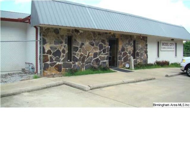
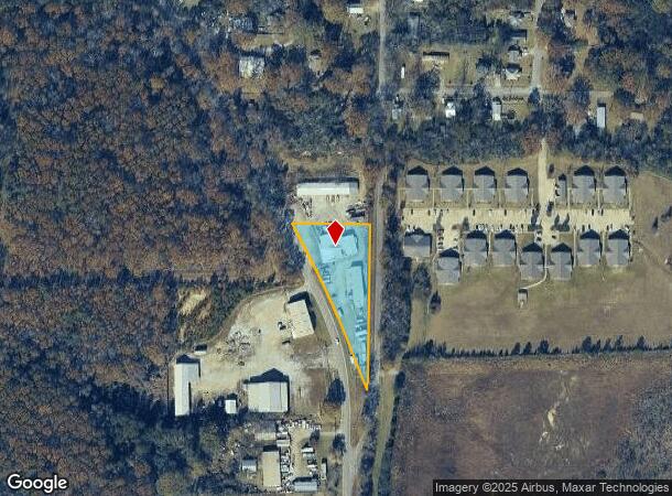
3017 Alexandria Rd
18-09-31-2-002-051.001
Add To Edmonson Hights
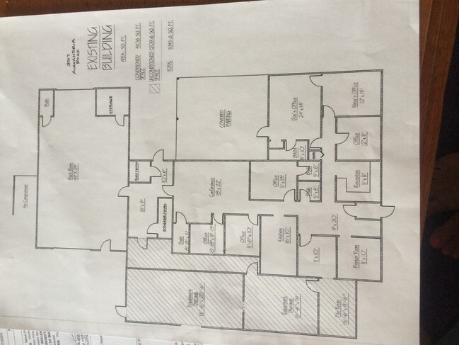
Storebuilding
SEC 31 TSP 15S RNG 08E A LOT IN SW 1/4 OF NW 1/4 & SE 1/4 OF NW 1/4 DESC AS FOL BEG @ PT ON E LINE OF ALEXANDRIA RD BEING 400
X
Calhoun
01015C0312E
Alabama
2025
1.30 AC
2025
Gadsden/Anniston Area
000400
Other Market Areas
1,581 SF
Anniston-Oxford-Jacksonville, AL
DEMOGRAPHICS near 3017 Alexandria Rd
1 Mile
3 Mile
5 Mile
2024 Total Population
4,663
23,213
41,470
2029 Population
4,717
23,310
41,321
Pop Growth 2024-2029
+ 1.16%
+ 0.42%
(0.36%)
Average Age
41
41
42
2024 Total Households
2,015
9,734
17,347
HH Growth 2024-2029
+ 0.99%
+ 0.45%
(0.37%)
Median Household Inc
$23,916
$30,472
$39,105
Avg Household Size
2.20
2.20
2.20
2024 Avg HH Vehicles
2.00
2.00
2.00
Median Home Value
$59,110
$75,335
$97,613
Median Year Built
1958
1967
1972
Nearby Places
Map Layers
Map Styles
 Street
 Aerial
- Restaurants
- Banks
- Shops
- Fitness
- Groceries
PUBLIC TRANSPORTATION
COMMUTER RAIL
Anniston Amtrak Station (Crescent - Amtrak)
DRIVE
WALK
Distance
Anniston Amtrak Station (Crescent - Amtrak)
7 min
3.2 mi
Freight Ports
Port of Panama City
DRIVE
WALK
Distance
Port of Panama City
369 min
295.2 mi
Nearby Properties
Address
Land Use
TOTAL SIZE
Lot Size
Zoning
Address
Land Use
TOTAL SIZE
Lot Size
Zoning
319,650 SF
10.69 AC
Address
Land Use
TOTAL SIZE
Lot Size
Zoning
12,496 SF
7.39 AC
Address
Land Use
TOTAL SIZE
Lot Size
Zoning
4,520 SF
8.20 AC
Address
Land Use
TOTAL SIZE
Lot Size
Zoning
73,027 SF
1.60 AC
Address
Land Use
TOTAL SIZE
Lot Size
Zoning
21,766 SF
3.06 AC
Address
Land Use
TOTAL SIZE
Lot Size
Zoning
18.55 AC
Address
Land Use
TOTAL SIZE
Lot Size
Zoning
16,541 SF
19.44 AC
Address
Land Use
TOTAL SIZE
Lot Size
Zoning
138,119 SF
13.55 AC
Address
Land Use
TOTAL SIZE
Lot Size
Zoning
31,832 SF
16 AC
Address
Land Use
TOTAL SIZE
Lot Size
Zoning
203,573 SF
17.16 AC
Address
Land Use
TOTAL SIZE
Lot Size
Zoning
14,082 SF
3.85 AC
Address
Land Use
TOTAL SIZE
Lot Size
Zoning
5,581 SF
1.01 AC
Address
Land Use
TOTAL SIZE
Lot Size
Zoning
42,158 SF
5.20 AC
Address
Land Use
TOTAL SIZE
Lot Size
Zoning
3.67 AC
Address
Land Use
TOTAL SIZE
Lot Size
Zoning
71,060 SF
2.20 AC
Address
Land Use
TOTAL SIZE
Lot Size
Zoning
103,550 SF
9.15 AC
Address
Land Use
TOTAL SIZE
Lot Size
Zoning
6.94 AC
Address
Land Use
TOTAL SIZE
Lot Size
Zoning
6,912 SF
12.68 AC
Address
Land Use
TOTAL SIZE
Lot Size
Zoning
34,564 SF
1.60 AC
Address
Land Use
TOTAL SIZE
Lot Size
Zoning
Address
Land Use
TOTAL SIZE
Lot Size
Zoning
13,568 SF
1.60 AC
Address
Land Use
TOTAL SIZE
Lot Size
Zoning
9,034 SF
4.70 AC
Address
Land Use
TOTAL SIZE
Lot Size
Zoning
40,520 SF
4.01 AC
Address
Land Use
TOTAL SIZE
Lot Size
Zoning
25,325 SF
2.29 AC
Address
Land Use
TOTAL SIZE
Lot Size
Zoning
5,780 SF
62.60 AC
Address
Land Use
TOTAL SIZE
Lot Size
Zoning
47,164 SF
1.37 AC
Address
Land Use
TOTAL SIZE
Lot Size
Zoning
Address
Land Use
TOTAL SIZE
Lot Size
Zoning
65,545 SF
0.80 AC
Address
Land Use
TOTAL SIZE
Lot Size
Zoning
27,338 SF
3.60 AC
Address
Land Use
TOTAL SIZE
Lot Size
Zoning
93,926 SF
26.88 AC
The World's #1 Commercial Real Estate Marketplace
Connect with us
© 2025 CoStar Group
The information above has been obtained from sources believed reliable. While we do not doubt its accuracy we have not verified it and make no guarantee, warranty or representation about it. It is your responsibility to independently confirm its accuracy and completeness. Any projections, opinions, assumptions, or estimates used are for example only and do not represent the current or future performance of the property. The value of this transaction to you depends on tax and other factors which should be evaluated by your tax, financial, and legal advisors. You and your advisors should conduct a careful, independent investigation of the property to determine to your satisfaction the suitability of the property for your needs.