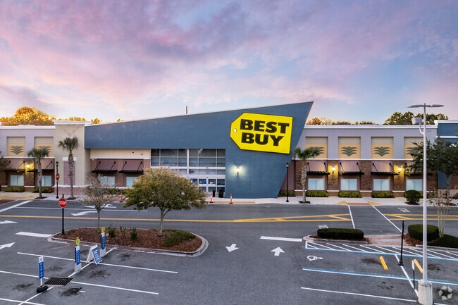
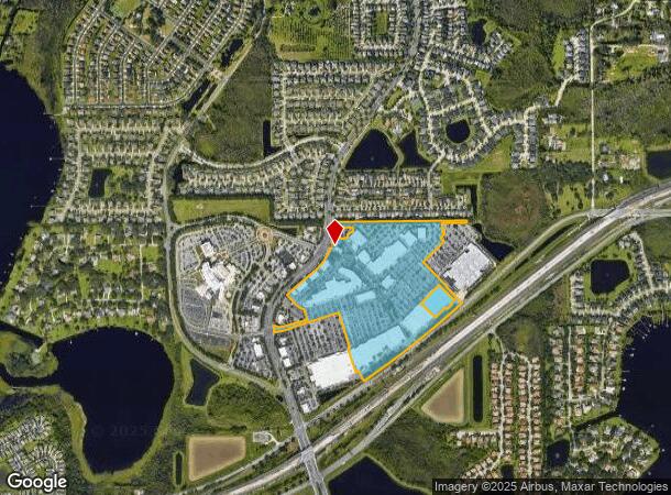
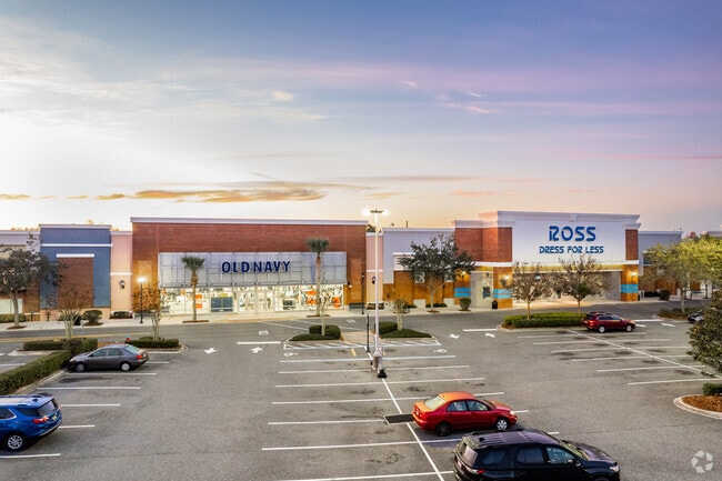
Property Record
3017 Daniels Rd, Winter Garden, FL 34787
NEARBY LISTINGS FOR SALE OR LEASE
Property Detail
3017 Daniels Rd
Orlando-Kissimmee-Sanford, FL
Winter Garden Vlg At Fowler Groves
35-2227-9398-03-010
WINTER GARDEN VILLAGE AT FOWLER GROVES 6 9/82 LOT 1 BLK 3 (LESS COMM AT NW COR OF LOT 1 BLK 3 TH RUN S02-22-02E 19.85 FT TO CURVE CONCAVE WLY RAD 786.20 FT DELTA 03-40-20 FOR 50.39 FT TO POB TH RUN N89
Regionalshoppingcenterormallwithanchorstore
Orange
X
Florida
12095C0215H
1
2024
55 AC
2025
SW Orange Outlying
017118
Orlando
632,562 SF
DEMOGRAPHICS near 3017 Daniels Rd
1 Mile
3 Mile
5 Mile
2024 Total Population
4,865
56,769
130,814
2029 Population
4,970
58,625
135,598
Pop Growth 2024-2029
+ 2.16%
+ 3.27%
+ 3.66%
Average Age
39
39
39
2024 Total Households
1,554
19,097
44,546
HH Growth 2024-2029
+ 2.12%
+ 3.27%
+ 3.66%
Median Household Inc
$146,093
$107,398
$98,836
Avg Household Size
3.10
2.90
2.90
2024 Avg HH Vehicles
2.00
2.00
2.00
Median Home Value
$459,770
$428,839
$418,708
Median Year Built
2004
2004
2004
Nearby Places
Map Layers
Map Styles
 Street
 Aerial
- Restaurants
- Banks
- Shops
- Fitness
- Groceries
PUBLIC TRANSPORTATION
AIRPORT
Orlando International
DRIVE
WALK
Distance
Orlando International
35 min
24.7 mi
Orlando Sanford International
DRIVE
WALK
Distance
Orlando Sanford International
55 min
42.2 mi
Freight Ports
Port Canaveral
DRIVE
WALK
Distance
Port Canaveral
83 min
67.3 mi
Nearby Properties
Address
Land Use
TOTAL SIZE
Lot Size
Zoning
Address
Land Use
TOTAL SIZE
Lot Size
Zoning
412,588 SF
24.35 AC
PCD
Address
Land Use
TOTAL SIZE
Lot Size
Zoning
375,315 SF
64.92 AC
R-CE
Address
Land Use
TOTAL SIZE
Lot Size
Zoning
531,197 SF
51.22 AC
C-WG-PCD
Address
Land Use
TOTAL SIZE
Lot Size
Zoning
782,050 SF
44.78 AC
A-1
Address
Land Use
TOTAL SIZE
Lot Size
Zoning
693,608 SF
24.41 AC
PUD-HD
Address
Land Use
TOTAL SIZE
Lot Size
Zoning
342,875 SF
11.35 AC
PUD-COMM
Address
Land Use
TOTAL SIZE
Lot Size
Zoning
347,506 SF
3.55 AC
PUD-MD
Address
Land Use
TOTAL SIZE
Lot Size
Zoning
167,285 SF
164.77 AC
C-3
Address
Land Use
TOTAL SIZE
Lot Size
Zoning
378,520 SF
25.53 AC
R-2
Address
Land Use
TOTAL SIZE
Lot Size
Zoning
209,545 SF
20.04 AC
R-3
Address
Land Use
TOTAL SIZE
Lot Size
Zoning
203,729 SF
11.46 AC
PUD-HD
Address
Land Use
TOTAL SIZE
Lot Size
Zoning
364,641 SF
29.26 AC
R-3
Address
Land Use
TOTAL SIZE
Lot Size
Zoning
80,744 SF
9.40 AC
R-2
Address
Land Use
TOTAL SIZE
Lot Size
Zoning
170,960 SF
22.17 AC
R-2
Address
Land Use
TOTAL SIZE
Lot Size
Zoning
95,034 SF
67.66 AC
PUD
Address
Land Use
TOTAL SIZE
Lot Size
Zoning
139.49 AC
Address
Land Use
TOTAL SIZE
Lot Size
Zoning
151,838 SF
7.15 AC
R-1
Address
Land Use
TOTAL SIZE
Lot Size
Zoning
111,130 SF
15 AC
P-D
Address
Land Use
TOTAL SIZE
Lot Size
Zoning
64,349 SF
10.62 AC
P-D
Address
Land Use
TOTAL SIZE
Lot Size
Zoning
94,877 SF
7.01 AC
PCD
Address
Land Use
TOTAL SIZE
Lot Size
Zoning
155,663 SF
17.02 AC
C-2
Address
Land Use
TOTAL SIZE
Lot Size
Zoning
191,948 SF
13.09 AC
PCD
Address
Land Use
TOTAL SIZE
Lot Size
Zoning
98,995 SF
11.48 AC
PUD
Address
Land Use
TOTAL SIZE
Lot Size
Zoning
96,020 SF
3.98 AC
I-2
Address
Land Use
TOTAL SIZE
Lot Size
Zoning
177,744 SF
19.48 AC
R-3
Address
Land Use
TOTAL SIZE
Lot Size
Zoning
93,948 SF
8.98 AC
A-1
Address
Land Use
TOTAL SIZE
Lot Size
Zoning
102,228 SF
12 AC
R-2
Address
Land Use
TOTAL SIZE
Lot Size
Zoning
117,724 SF
20.93 AC
R-1
Address
Land Use
TOTAL SIZE
Lot Size
Zoning
101,965 SF
13.50 AC
P-D
The World's #1 Commercial Real Estate Marketplace
Connect with us
© 2026 CoStar Group
The information above has been obtained from sources believed reliable. While we do not doubt its accuracy we have not verified it and make no guarantee, warranty or representation about it. It is your responsibility to independently confirm its accuracy and completeness. Any projections, opinions, assumptions, or estimates used are for example only and do not represent the current or future performance of the property. The value of this transaction to you depends on tax and other factors which should be evaluated by your tax, financial, and legal advisors. You and your advisors should conduct a careful, independent investigation of the property to determine to your satisfaction the suitability of the property for your needs.