Property Record
3018 Charleston Hwy, West Columbia, SC 29172
NEARBY LISTINGS FOR SALE OR LEASE
Property Detail
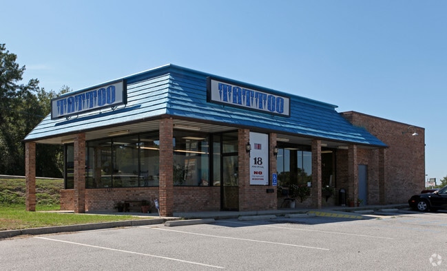
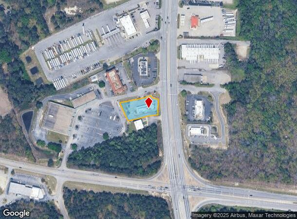
3018 Charleston Hwy
006896-02-030
PARCEL A & OTHER
Restaurantdrivein
Lexington
X
South Carolina
45063C0287J
0.66 AC
2025
Cayce/West Columbia
2024
Columbia
020605
Columbia, SC
2,019 SF
DEMOGRAPHICS near 3018 Charleston Hwy
1 Mile
3 Mile
5 Mile
2024 Total Population
941
16,528
66,941
2029 Population
1,021
18,046
72,742
Pop Growth 2024-2029
+ 8.50%
+ 9.18%
+ 8.67%
Average Age
39
41
37
2024 Total Households
421
7,094
28,098
HH Growth 2024-2029
+ 8.79%
+ 9.32%
+ 9.18%
Median Household Inc
$57,916
$55,806
$48,951
Avg Household Size
2.20
2.30
2.20
2024 Avg HH Vehicles
2.00
2.00
2.00
Median Home Value
$146,789
$143,815
$145,852
Median Year Built
1985
1975
1979
Nearby Places
Map Layers
Map Styles
 Street
 Aerial
- Restaurants
- Banks
- Shops
- Fitness
- Groceries
PUBLIC TRANSPORTATION
COMMUTER RAIL
DRIVE
WALK
Distance
13 min
6.8 mi
AIRPORT
Columbia Metro
DRIVE
WALK
Distance
Columbia Metro
17 min
6.9 mi
Nearby Properties
Address
Land Use
TOTAL SIZE
Lot Size
Zoning
Address
Land Use
TOTAL SIZE
Lot Size
Zoning
1,253,820 SF
87.15 AC
Address
Land Use
TOTAL SIZE
Lot Size
Zoning
3,614 SF
1,444.32 AC
ID
Address
Land Use
TOTAL SIZE
Lot Size
Zoning
466,400 SF
52.42 AC
ID
Address
Land Use
TOTAL SIZE
Lot Size
Zoning
4,586 SF
19.15 AC
Address
Land Use
TOTAL SIZE
Lot Size
Zoning
1,218 SF
8.99 AC
RG
Address
Land Use
TOTAL SIZE
Lot Size
Zoning
297,500 SF
20.26 AC
ID
Address
Land Use
TOTAL SIZE
Lot Size
Zoning
8,118 SF
10.98 AC
RG
Address
Land Use
TOTAL SIZE
Lot Size
Zoning
180,000 SF
27.57 AC
ID
Address
Land Use
TOTAL SIZE
Lot Size
Zoning
10,304 SF
11.89 AC
R1
Address
Land Use
TOTAL SIZE
Lot Size
Zoning
181,440 SF
10.69 AC
ID
Address
Land Use
TOTAL SIZE
Lot Size
Zoning
9,800 SF
13.52 AC
ID
Address
Land Use
TOTAL SIZE
Lot Size
Zoning
5,502 SF
16.15 AC
ID
Address
Land Use
TOTAL SIZE
Lot Size
Zoning
200,000 SF
10.58 AC
ID
Address
Land Use
TOTAL SIZE
Lot Size
Zoning
61,012 SF
5.34 AC
Address
Land Use
TOTAL SIZE
Lot Size
Zoning
200,000 SF
9.66 AC
ID
Address
Land Use
TOTAL SIZE
Lot Size
Zoning
180,000 SF
12.48 AC
ID
Address
Land Use
TOTAL SIZE
Lot Size
Zoning
279,568 SF
11.38 AC
ID
Address
Land Use
TOTAL SIZE
Lot Size
Zoning
44,352 SF
7.55 AC
D1
Address
Land Use
TOTAL SIZE
Lot Size
Zoning
254,399 SF
49.79 AC
ID
Address
Land Use
TOTAL SIZE
Lot Size
Zoning
202,029 SF
21.13 AC
ID
Address
Land Use
TOTAL SIZE
Lot Size
Zoning
35.70 AC
Address
Land Use
TOTAL SIZE
Lot Size
Zoning
215,770 SF
24.51 AC
Address
Land Use
TOTAL SIZE
Lot Size
Zoning
50,400 SF
11 AC
ID
Address
Land Use
TOTAL SIZE
Lot Size
Zoning
92.08 AC
Address
Land Use
TOTAL SIZE
Lot Size
Zoning
104,000 SF
18.53 AC
Address
Land Use
TOTAL SIZE
Lot Size
Zoning
Address
Land Use
TOTAL SIZE
Lot Size
Zoning
53.82 AC
Address
Land Use
TOTAL SIZE
Lot Size
Zoning
14,602 SF
2.41 AC
C2
Address
Land Use
TOTAL SIZE
Lot Size
Zoning
28.17 AC
Address
Land Use
TOTAL SIZE
Lot Size
Zoning
50,000 SF
6.89 AC
ID
The World's #1 Commercial Real Estate Marketplace
Connect with us
© 2025 CoStar Group
The information above has been obtained from sources believed reliable. While we do not doubt its accuracy we have not verified it and make no guarantee, warranty or representation about it. It is your responsibility to independently confirm its accuracy and completeness. Any projections, opinions, assumptions, or estimates used are for example only and do not represent the current or future performance of the property. The value of this transaction to you depends on tax and other factors which should be evaluated by your tax, financial, and legal advisors. You and your advisors should conduct a careful, independent investigation of the property to determine to your satisfaction the suitability of the property for your needs.