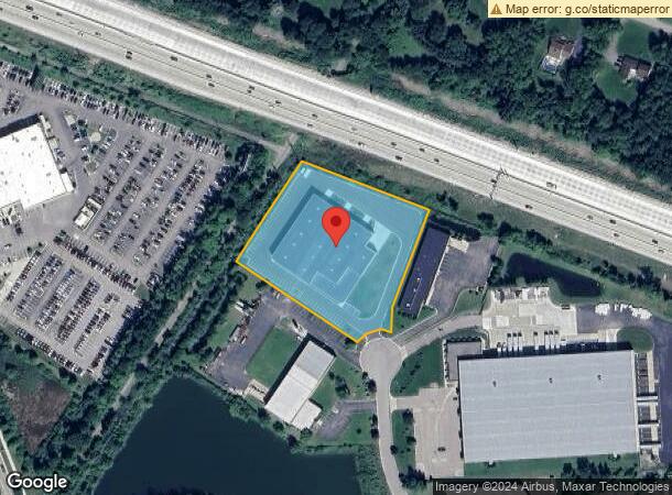
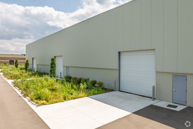
Property Record
30180 Research Dr, New Hudson, MI 48165
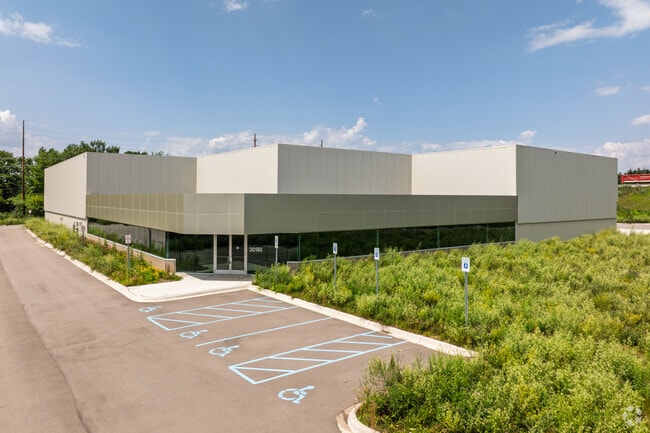
This Property Is For Sale
Current Lease Availabilities
NEARBY LISTINGS FOR SALE OR LEASE
Property Detail
30180 Research Dr
21-03-253-009
Oakland County Condominium
Manufacturinglight
T1N, R7E, SEC 3 OAKLAND COUNTY CONDOMINIUM PLAN NO 1102 LYON INDUSTRIAL/RESEARCH CENTRE UNIT 8 L 18348 P 31 2-18-99 FR 003
X
Oakland
26125C0463F
Michigan
2024
3.20 AC
2025
Central I-96 Corridor
138600
Detroit
42,842 SF
Detroit-Warren-Dearborn, MI
DEMOGRAPHICS near 30180 Research Dr
1 Mile
3 Mile
5 Mile
2024 Total Population
1,736
14,426
68,082
2029 Population
1,720
14,352
67,337
Pop Growth 2024-2029
(0.92%)
(0.51%)
(1.09%)
Average Age
39
39
39
2024 Total Households
622
5,297
26,882
HH Growth 2024-2029
(0.96%)
(0.59%)
(1.49%)
Median Household Inc
$113,274
$97,219
$94,518
Avg Household Size
2.80
2.70
2.50
2024 Avg HH Vehicles
2.00
2.00
2.00
Median Home Value
$374,352
$362,996
$359,173
Median Year Built
1996
1994
1992
Nearby Places
Map Layers
Map Styles
 Street
 Aerial
- Restaurants
- Banks
- Shops
- Fitness
- Groceries
PUBLIC TRANSPORTATION
AIRPORT
Detroit Metro Wayne County
DRIVE
WALK
Distance
Detroit Metro Wayne County
42 min
34.1 mi
Freight Ports
Port of Toledo
DRIVE
WALK
Distance
Port of Toledo
92 min
75.8 mi
Nearby Properties
Address
Land Use
TOTAL SIZE
Lot Size
Zoning
Address
Land Use
TOTAL SIZE
Lot Size
Zoning
433,305 SF
19.63 AC
Address
Land Use
TOTAL SIZE
Lot Size
Zoning
317,215 SF
23.63 AC
Address
Land Use
TOTAL SIZE
Lot Size
Zoning
325,725 SF
30.46 AC
Address
Land Use
TOTAL SIZE
Lot Size
Zoning
306,804 SF
Address
Land Use
TOTAL SIZE
Lot Size
Zoning
140,366 SF
30.67 AC
II
Address
Land Use
TOTAL SIZE
Lot Size
Zoning
195,802 SF
9.87 AC
BV
Address
Land Use
TOTAL SIZE
Lot Size
Zoning
172,700 SF
Address
Land Use
TOTAL SIZE
Lot Size
Zoning
7,471 SF
114.63 AC
MM
Address
Land Use
TOTAL SIZE
Lot Size
Zoning
154,490 SF
Address
Land Use
TOTAL SIZE
Lot Size
Zoning
279,807 SF
31.24 AC
II
Address
Land Use
TOTAL SIZE
Lot Size
Zoning
287,382 SF
42.91 AC
II
Address
Land Use
TOTAL SIZE
Lot Size
Zoning
154,490 SF
Address
Land Use
TOTAL SIZE
Lot Size
Zoning
286,708 SF
Address
Land Use
TOTAL SIZE
Lot Size
Zoning
223,110 SF
18.53 AC
BI
Address
Land Use
TOTAL SIZE
Lot Size
Zoning
325,725 SF
Address
Land Use
TOTAL SIZE
Lot Size
Zoning
150,217 SF
10.22 AC
IV
Address
Land Use
TOTAL SIZE
Lot Size
Zoning
9,784 SF
68.90 AC
MM
Address
Land Use
TOTAL SIZE
Lot Size
Zoning
148,298 SF
20.43 AC
Address
Land Use
TOTAL SIZE
Lot Size
Zoning
66,070 SF
Address
Land Use
TOTAL SIZE
Lot Size
Zoning
117,308 SF
Address
Land Use
TOTAL SIZE
Lot Size
Zoning
167,616 SF
39.18 AC
Address
Land Use
TOTAL SIZE
Lot Size
Zoning
154,500 SF
11.64 AC
II
Address
Land Use
TOTAL SIZE
Lot Size
Zoning
80,023 SF
12.44 AC
IRO
Address
Land Use
TOTAL SIZE
Lot Size
Zoning
93,109 SF
8.63 AC
RI
Address
Land Use
TOTAL SIZE
Lot Size
Zoning
286,708 SF
33.46 AC
Address
Land Use
TOTAL SIZE
Lot Size
Zoning
101,749 SF
8.51 AC
Address
Land Use
TOTAL SIZE
Lot Size
Zoning
107,850 SF
21.38 AC
Address
Land Use
TOTAL SIZE
Lot Size
Zoning
132,821 SF
13.48 AC
BI
Address
Land Use
TOTAL SIZE
Lot Size
Zoning
32,826 SF
22.12 AC
BI
Address
Land Use
TOTAL SIZE
Lot Size
Zoning
167,616 SF
20.53 AC
ME
The World's #1 Commercial Real Estate Marketplace
Connect with us
© 2026 CoStar Group
The information above has been obtained from sources believed reliable. While we do not doubt its accuracy we have not verified it and make no guarantee, warranty or representation about it. It is your responsibility to independently confirm its accuracy and completeness. Any projections, opinions, assumptions, or estimates used are for example only and do not represent the current or future performance of the property. The value of this transaction to you depends on tax and other factors which should be evaluated by your tax, financial, and legal advisors. You and your advisors should conduct a careful, independent investigation of the property to determine to your satisfaction the suitability of the property for your needs.