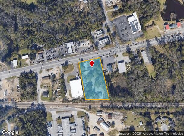
Property Record
3019 Augusta Rd, West Columbia, SC 29170
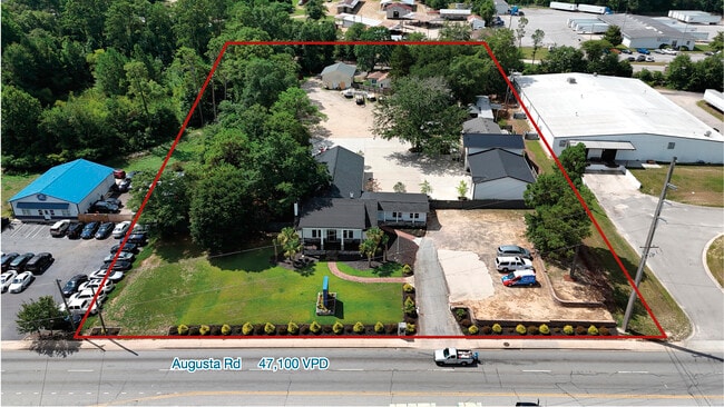
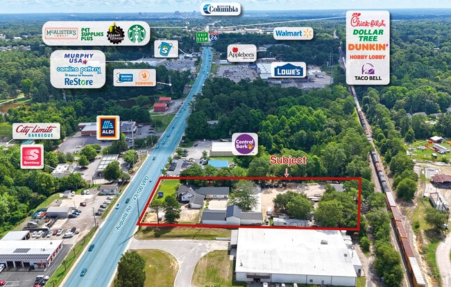
This Property Is For Sale
NEARBY LISTINGS FOR SALE OR LEASE
Property Detail
3019 Augusta Rd
Columbia, SC
Donny Phipps
004599-06-007
Lexington
Sfr
South Carolina
X
2.27 AC
45063C0276J
Cayce/West Columbia
1,964 SF
Columbia
DEMOGRAPHICS near 3019 Augusta Rd
1 Mile
3 Mile
5 Mile
2024 Total Population
4,790
39,378
110,148
2029 Population
5,225
42,925
118,107
Pop Growth 2024-2029
+ 9.08%
+ 9.01%
+ 7.23%
Average Age
40
41
38
2024 Total Households
1,985
17,228
48,439
HH Growth 2024-2029
+ 9.22%
+ 9.20%
+ 7.31%
Median Household Inc
$59,297
$56,320
$55,062
Avg Household Size
2.30
2.20
2.20
2024 Avg HH Vehicles
2.00
2.00
2.00
Median Home Value
$143,827
$156,335
$162,724
Median Year Built
1985
1978
1980
Nearby Places
Map Layers
Map Styles
 Street
 Aerial
- Restaurants
- Banks
- Shops
- Fitness
- Groceries
PUBLIC TRANSPORTATION
COMMUTER RAIL
Columbia Amtrak Station (Silver Star - Amtrak)
DRIVE
WALK
Distance
Columbia Amtrak Station (Silver Star - Amtrak)
9 min
5.4 mi
AIRPORT
Columbia Metro
DRIVE
WALK
Distance
Columbia Metro
17 min
6.9 mi
Freight Ports
North Charleston Terminal
DRIVE
WALK
Distance
North Charleston Terminal
117 min
103.2 mi
Nearby Properties
Address
Land Use
TOTAL SIZE
Lot Size
Zoning
Address
Land Use
TOTAL SIZE
Lot Size
Zoning
461,888 SF
61.50 AC
ID
Address
Land Use
TOTAL SIZE
Lot Size
Zoning
3,614 SF
1,444.32 AC
ID
Address
Land Use
TOTAL SIZE
Lot Size
Zoning
8,330 SF
19.10 AC
ID
Address
Land Use
TOTAL SIZE
Lot Size
Zoning
1,218 SF
8.99 AC
RG
Address
Land Use
TOTAL SIZE
Lot Size
Zoning
3,080 SF
18.07 AC
R
Address
Land Use
TOTAL SIZE
Lot Size
Zoning
222,557 SF
26.90 AC
ID
Address
Land Use
TOTAL SIZE
Lot Size
Zoning
10,304 SF
11.89 AC
R1
Address
Land Use
TOTAL SIZE
Lot Size
Zoning
107,890 SF
21.99 AC
C2
Address
Land Use
TOTAL SIZE
Lot Size
Zoning
257,688 SF
23.03 AC
ID
Address
Land Use
TOTAL SIZE
Lot Size
Zoning
99,628 SF
13.09 AC
RD
Address
Land Use
TOTAL SIZE
Lot Size
Zoning
318,309 SF
33.51 AC
ID
Address
Land Use
TOTAL SIZE
Lot Size
Zoning
41,860 SF
5.67 AC
C3
Address
Land Use
TOTAL SIZE
Lot Size
Zoning
7,383 SF
4.85 AC
ID
Address
Land Use
TOTAL SIZE
Lot Size
Zoning
34,267 SF
7.53 AC
ID
Address
Land Use
TOTAL SIZE
Lot Size
Zoning
70,740 SF
13 AC
ID
Address
Land Use
TOTAL SIZE
Lot Size
Zoning
430.11 AC
ID
Address
Land Use
TOTAL SIZE
Lot Size
Zoning
3,825 SF
18.45 AC
RD
Address
Land Use
TOTAL SIZE
Lot Size
Zoning
79,951 SF
3.31 AC
RD
Address
Land Use
TOTAL SIZE
Lot Size
Zoning
86,711 SF
3.46 AC
ID
Address
Land Use
TOTAL SIZE
Lot Size
Zoning
54,000 SF
8.60 AC
ID
Address
Land Use
TOTAL SIZE
Lot Size
Zoning
147,166 SF
18.27 AC
ID
Address
Land Use
TOTAL SIZE
Lot Size
Zoning
202,029 SF
21.13 AC
ID
Address
Land Use
TOTAL SIZE
Lot Size
Zoning
14,169 SF
6.46 AC
ID
Address
Land Use
TOTAL SIZE
Lot Size
Zoning
29,991 SF
1.85 AC
C3
Address
Land Use
TOTAL SIZE
Lot Size
Zoning
162,500 SF
12.36 AC
ID
Address
Land Use
TOTAL SIZE
Lot Size
Zoning
14,602 SF
2.41 AC
C2
Address
Land Use
TOTAL SIZE
Lot Size
Zoning
115,000 SF
11.99 AC
ID
Address
Land Use
TOTAL SIZE
Lot Size
Zoning
73,778 SF
4.95 AC
A
Address
Land Use
TOTAL SIZE
Lot Size
Zoning
14,154 SF
2.53 AC
ID
Address
Land Use
TOTAL SIZE
Lot Size
Zoning
49,708 SF
2.69 AC
ID
The World's #1 Commercial Real Estate Marketplace
Connect with us
© 2025 CoStar Group
The information above has been obtained from sources believed reliable. While we do not doubt its accuracy we have not verified it and make no guarantee, warranty or representation about it. It is your responsibility to independently confirm its accuracy and completeness. Any projections, opinions, assumptions, or estimates used are for example only and do not represent the current or future performance of the property. The value of this transaction to you depends on tax and other factors which should be evaluated by your tax, financial, and legal advisors. You and your advisors should conduct a careful, independent investigation of the property to determine to your satisfaction the suitability of the property for your needs.