Property Record
302 Avenue O, Lubbock, TX 79401
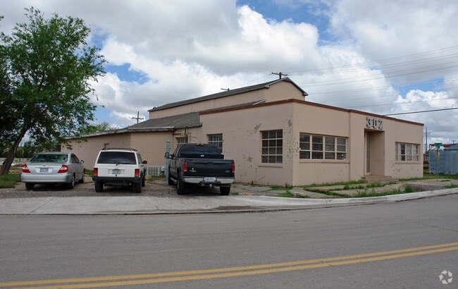

Property Detail
302 Avenue O
Lubbock, TX
FALCON STEEL TR B
R102938
LUBBOCK
Officebuilding
Texas
AE The base floodplain where base flood elevations are provided. AE Zones are now used on new format FIRMs instead of A1-A30 Zones.
b
2024
0.18 AC
2025
North Inner Loop
000605
Lubbock
4,480 SF
NEARBY LISTINGS FOR SALE OR LEASE
DEMOGRAPHICS near 302 Avenue O
1 mile
3 mile
5 mile
2025 Total Population
9,293
65,881
142,602
2030 Population
9,708
68,483
148,032
Pop Growth 2025-2030
+ 4.47%
+ 3.95%
+ 3.81%
Average Age
33
34
35
2025 Total Households
3,477
23,642
53,340
HH Growth 2025-2030
+ 4.60%
+ 4.78%
+ 4.33%
Median Household Inc
$31,642
$36,633
$47,285
Avg Household Size
2.20
2.30
2.40
2025 Avg HH Vehicles
2.00
2.00
2.00
Median Home Value
$95,203
$92,519
$157,680
Median Year Built
1996
1971
1971
Nearby Places
Map Layers
Map Styles
 Street
 Aerial
Layers
 Traffic
 Biking
Places
Listings with unknown addresses are not visible on the map
- Restaurants
- Banks
- Shops
- Fitness
- Groceries
PUBLIC TRANSPORTATION
AIRPORT
Lubbock Preston Smith International
Drive
Walk
Distance
Lubbock Preston Smith International
21 min
10.4 mi
Freight Ports
Tulsa Port Of Catoosa
Drive
Walk
Distance
Tulsa Port Of Catoosa
505 min
468.1 mi
SALE & LEASE HISTORY
LISTING DATE
SALE/LEASE

Aug 12, 2021
For Lease
Aug 12, 2021
For Sale
Apr 24, 2019
For Lease
Nearby Properties
Address
Land Use
TOTAL SIZE
Lot Size
Zoning
Address
Land Use
TOTAL SIZE
Lot Size
Zoning
281,000 SF
6.19 AC
Address
Land Use
TOTAL SIZE
Lot Size
Zoning
79,376 SF
11.25 AC
Address
Land Use
TOTAL SIZE
Lot Size
Zoning
15,506 SF
18.67 AC
Address
Land Use
TOTAL SIZE
Lot Size
Zoning
353,616 SF
5.24 AC
Address
Land Use
TOTAL SIZE
Lot Size
Zoning
379,029 SF
29.43 AC
Address
Land Use
TOTAL SIZE
Lot Size
Zoning
351,150 SF
3.65 AC
Address
Land Use
TOTAL SIZE
Lot Size
Zoning
21,110 SF
13.02 AC
Address
Land Use
TOTAL SIZE
Lot Size
Zoning
342,611 SF
12.21 AC
Address
Land Use
TOTAL SIZE
Lot Size
Zoning
409,380 SF
30.13 AC
Address
Land Use
TOTAL SIZE
Lot Size
Zoning
321,540 SF
10.87 AC
Address
Land Use
TOTAL SIZE
Lot Size
Zoning
286,541 SF
4.25 AC
Address
Land Use
TOTAL SIZE
Lot Size
Zoning
304,276 SF
22.69 AC
Address
Land Use
TOTAL SIZE
Lot Size
Zoning
179,627 SF
2.66 AC
Address
Land Use
TOTAL SIZE
Lot Size
Zoning
120,867 SF
3.41 AC
Address
Land Use
TOTAL SIZE
Lot Size
Zoning
14.37 AC
Address
Land Use
TOTAL SIZE
Lot Size
Zoning
230,286 SF
8.01 AC
Address
Land Use
TOTAL SIZE
Lot Size
Zoning
122,016 SF
1.13 AC
Address
Land Use
TOTAL SIZE
Lot Size
Zoning
122,976 SF
14.50 AC
Address
Land Use
TOTAL SIZE
Lot Size
Zoning
396,570 SF
2.56 AC
Address
Land Use
TOTAL SIZE
Lot Size
Zoning
201,700 SF
16.98 AC
Address
Land Use
TOTAL SIZE
Lot Size
Zoning
400,401 SF
2.76 AC
Address
Land Use
TOTAL SIZE
Lot Size
Zoning
92,624 SF
2.77 AC
Address
Land Use
TOTAL SIZE
Lot Size
Zoning
202,925 SF
25.10 AC
Address
Land Use
TOTAL SIZE
Lot Size
Zoning
202,206 SF
18.86 AC
Address
Land Use
TOTAL SIZE
Lot Size
Zoning
143,905 SF
0.28 AC
Address
Land Use
TOTAL SIZE
Lot Size
Zoning
231,940 SF
7.67 AC
Address
Land Use
TOTAL SIZE
Lot Size
Zoning
324.17 AC
Address
Land Use
TOTAL SIZE
Lot Size
Zoning
7.68 AC
Address
Land Use
TOTAL SIZE
Lot Size
Zoning
64,317 SF
4.50 AC
Address
Land Use
TOTAL SIZE
Lot Size
Zoning
625.50 AC
The World's #1 Commercial Real Estate Marketplace
Connect with us
© 2026 CoStar Group
The information above has been obtained from sources believed reliable. While we do not doubt its accuracy we have not verified it and make no guarantee, warranty or representation about it. It is your responsibility to independently confirm its accuracy and completeness. Any projections, opinions, assumptions, or estimates used are for example only and do not represent the current or future performance of the property. The value of this transaction to you depends on tax and other factors which should be evaluated by your tax, financial, and legal advisors. You and your advisors should conduct a careful, independent investigation of the property to determine to your satisfaction the suitability of the property for your needs.