Property Record
302 E 82Nd St, Lubbock, TX 79404
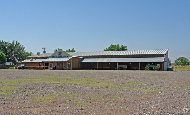

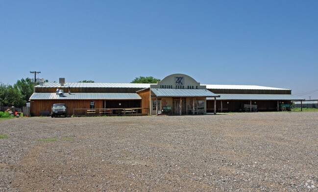
Property Detail
302 E 82Nd St
Lubbock, TX
Winston Est
R85120
BLK E SEC 7 AB 48 TR 5 & 6 LESS N150 WINSTON EST ACS: 2.8
Commercialnec
Lubbock
X
Texas
48303C0315G
90055
2024
2.80 AC
2025
Outlying Lubbock County
002500
Lubbock
11,504 SF
NEARBY LISTINGS FOR SALE OR LEASE
DEMOGRAPHICS near 302 E 82Nd St
1 mile
3 mile
5 mile
2024 Total Population
3,194
41,816
119,567
2029 Population
3,408
44,300
126,993
Pop Growth 2024-2029
+ 6.70%
+ 5.94%
+ 6.21%
Average Age
35
35
36
2024 Total Households
1,033
15,723
46,867
HH Growth 2024-2029
+ 7.07%
+ 6.15%
+ 6.47%
Median Household Inc
$67,500
$51,960
$56,775
Avg Household Size
2.70
2.60
2.40
2024 Avg HH Vehicles
2.00
2.00
2.00
Median Home Value
$97,312
$137,582
$178,396
Median Year Built
1990
1979
1977
Nearby Places
Map Layers
Map Styles
 Street
 Aerial
Transit
 Traffic
 Biking
Places
Listings with unknown addresses are not visible on the map
- Restaurants
- Banks
- Shops
- Fitness
- Groceries
PUBLIC TRANSPORTATION
AIRPORT
Lubbock Preston Smith International
Drive
Walk
Distance
Lubbock Preston Smith International
28 min
16.2 mi
Nearby Properties
Address
Land Use
TOTAL SIZE
Lot Size
Zoning
Address
Land Use
TOTAL SIZE
Lot Size
Zoning
709,350 SF
98.60 AC
Address
Land Use
TOTAL SIZE
Lot Size
Zoning
176,165 SF
36.61 AC
Address
Land Use
TOTAL SIZE
Lot Size
Zoning
167,208 SF
10.09 AC
Address
Land Use
TOTAL SIZE
Lot Size
Zoning
169,139 SF
12.07 AC
Address
Land Use
TOTAL SIZE
Lot Size
Zoning
157,644 SF
9.69 AC
Address
Land Use
TOTAL SIZE
Lot Size
Zoning
76,680 SF
4.95 AC
Address
Land Use
TOTAL SIZE
Lot Size
Zoning
421,200 SF
43.22 AC
Address
Land Use
TOTAL SIZE
Lot Size
Zoning
202,036 SF
17.12 AC
Address
Land Use
TOTAL SIZE
Lot Size
Zoning
205,150 SF
23.43 AC
Address
Land Use
TOTAL SIZE
Lot Size
Zoning
71,329 SF
14 AC
Address
Land Use
TOTAL SIZE
Lot Size
Zoning
150,000 SF
216.67 AC
Address
Land Use
TOTAL SIZE
Lot Size
Zoning
24,084 SF
2.44 AC
Address
Land Use
TOTAL SIZE
Lot Size
Zoning
192,128 SF
9.87 AC
Address
Land Use
TOTAL SIZE
Lot Size
Zoning
121,899 SF
7.70 AC
Address
Land Use
TOTAL SIZE
Lot Size
Zoning
53,816 SF
1.32 AC
Address
Land Use
TOTAL SIZE
Lot Size
Zoning
131,497 SF
4.61 AC
Address
Land Use
TOTAL SIZE
Lot Size
Zoning
189,737 SF
31 AC
Address
Land Use
TOTAL SIZE
Lot Size
Zoning
88,310 SF
9.95 AC
Address
Land Use
TOTAL SIZE
Lot Size
Zoning
367,283 SF
36.77 AC
Address
Land Use
TOTAL SIZE
Lot Size
Zoning
113,156 SF
6.82 AC
Address
Land Use
TOTAL SIZE
Lot Size
Zoning
137,554 SF
8.50 AC
Address
Land Use
TOTAL SIZE
Lot Size
Zoning
55,824 SF
2.28 AC
Address
Land Use
TOTAL SIZE
Lot Size
Zoning
62,226 SF
6.90 AC
Address
Land Use
TOTAL SIZE
Lot Size
Zoning
69,391 SF
6.47 AC
Address
Land Use
TOTAL SIZE
Lot Size
Zoning
79,488 SF
5.23 AC
Address
Land Use
TOTAL SIZE
Lot Size
Zoning
87,030 SF
3.50 AC
Address
Land Use
TOTAL SIZE
Lot Size
Zoning
233,241 SF
12.52 AC
Address
Land Use
TOTAL SIZE
Lot Size
Zoning
40,720 SF
6.37 AC
Address
Land Use
TOTAL SIZE
Lot Size
Zoning
52,526 SF
7 AC
Address
Land Use
TOTAL SIZE
Lot Size
Zoning
159,054 SF
7.53 AC
The World's #1 Commercial Real Estate Marketplace
Connect with us
© 2026 CoStar Group
The information above has been obtained from sources believed reliable. While we do not doubt its accuracy we have not verified it and make no guarantee, warranty or representation about it. It is your responsibility to independently confirm its accuracy and completeness. Any projections, opinions, assumptions, or estimates used are for example only and do not represent the current or future performance of the property. The value of this transaction to you depends on tax and other factors which should be evaluated by your tax, financial, and legal advisors. You and your advisors should conduct a careful, independent investigation of the property to determine to your satisfaction the suitability of the property for your needs.