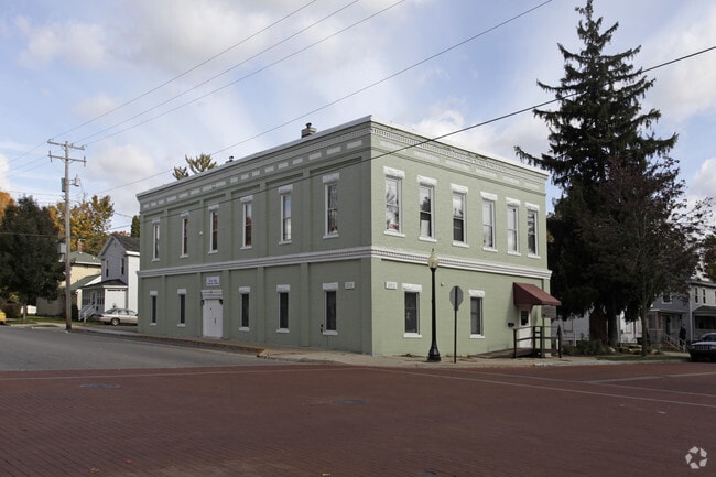
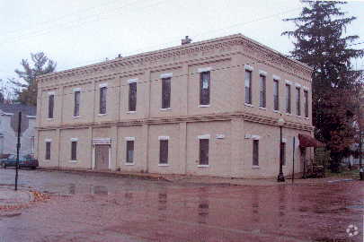
Property Record
302 E Main St, Ionia, MI 48846
Property Detail
302 E Main St
204-220-000-100-00
CITY OF BELDING SUPV MOONS PLAT, LOTS 192 & 193; ALSO THE W 96 FT LOT 194 & E 30 FT LOT 195; ALSO COM 30 FT W OF NE COR LOT
Commercialnec
Ionia
RT
Michigan
B and X Area of moderate flood hazard, usually the area between the limits of the 100-year and 500-year floods.
192-195
0
0.13 AC
2025
Ionia County
030200
West Michigan
3,200 SF
Grand Rapids-Wyoming-Kentwood, MI
NEARBY LISTINGS FOR SALE OR LEASE
-
-
View all Ionia listings for sale on LoopNet.com
DEMOGRAPHICS near 302 E Main St
1 mile
3 mile
5 mile
2025 Total Population
5,487
18,205
21,457
2030 Population
5,504
18,261
21,592
Pop Growth 2025-2030
+ 0.31%
+ 0.31%
+ 0.63%
Average Age
37
40
40
2025 Total Households
2,111
4,891
6,099
HH Growth 2025-2030
+ 0.33%
+ 0.70%
+ 1.05%
Median Household Inc
$58,105
$58,135
$60,205
Avg Household Size
2.50
2.50
2.50
2025 Avg HH Vehicles
2.00
2.00
2.00
Median Home Value
$199,445
$202,890
$208,897
Median Year Built
1948
1963
1969
Nearby Places
Map Layers
Map Styles
 Street
 Aerial
Layers
 Traffic
 Biking
Places
Listings with unknown addresses are not visible on the map
- Restaurants
- Banks
- Shops
- Fitness
- Groceries
PUBLIC TRANSPORTATION
AIRPORT
Capital Region International
Drive
Walk
Distance
Capital Region International
46 min
35.9 mi
Gerald R Ford International
Drive
Walk
Distance
Gerald R Ford International
48 min
35.9 mi
Nearby Properties
Address
Land Use
TOTAL SIZE
Lot Size
Zoning
Address
Land Use
TOTAL SIZE
Lot Size
Zoning
680,827 SF
50 AC
I-1
Address
Land Use
TOTAL SIZE
Lot Size
Zoning
209,286 SF
23.37 AC
Address
Land Use
TOTAL SIZE
Lot Size
Zoning
Address
Land Use
TOTAL SIZE
Lot Size
Zoning
1,286 SF
78 AC
R1
Address
Land Use
TOTAL SIZE
Lot Size
Zoning
8,960 SF
6.11 AC
Address
Land Use
TOTAL SIZE
Lot Size
Zoning
96,695 SF
11.92 AC
I-1
Address
Land Use
TOTAL SIZE
Lot Size
Zoning
111,316 SF
14.62 AC
Address
Land Use
TOTAL SIZE
Lot Size
Zoning
1,408 SF
136 AC
Address
Land Use
TOTAL SIZE
Lot Size
Zoning
131,333 SF
14.07 AC
Address
Land Use
TOTAL SIZE
Lot Size
Zoning
127,496 SF
10.70 AC
I-1
Address
Land Use
TOTAL SIZE
Lot Size
Zoning
94,800 SF
13.63 AC
Address
Land Use
TOTAL SIZE
Lot Size
Zoning
29,270 SF
3.09 AC
I-1
Address
Land Use
TOTAL SIZE
Lot Size
Zoning
31,585 SF
4.20 AC
RM-1
Address
Land Use
TOTAL SIZE
Lot Size
Zoning
1,940 SF
232.66 AC
Address
Land Use
TOTAL SIZE
Lot Size
Zoning
1,920 SF
68.57 AC
Address
Land Use
TOTAL SIZE
Lot Size
Zoning
16.30 AC
RM-1
Address
Land Use
TOTAL SIZE
Lot Size
Zoning
31,242 SF
0.25 AC
B-2
Address
Land Use
TOTAL SIZE
Lot Size
Zoning
23,904 SF
0.31 AC
B-2
Address
Land Use
TOTAL SIZE
Lot Size
Zoning
4.31 AC
RM-1
Address
Land Use
TOTAL SIZE
Lot Size
Zoning
2,396 SF
72.30 AC
Address
Land Use
TOTAL SIZE
Lot Size
Zoning
13,440 SF
5.50 AC
B-3
Address
Land Use
TOTAL SIZE
Lot Size
Zoning
5,247 SF
1.74 AC
Address
Land Use
TOTAL SIZE
Lot Size
Zoning
1,885 SF
1.17 AC
Address
Land Use
TOTAL SIZE
Lot Size
Zoning
7,200 SF
2.72 AC
Address
Land Use
TOTAL SIZE
Lot Size
Zoning
23,850 SF
4.30 AC
I-1
Address
Land Use
TOTAL SIZE
Lot Size
Zoning
1.45 AC
Address
Land Use
TOTAL SIZE
Lot Size
Zoning
6.48 AC
Address
Land Use
TOTAL SIZE
Lot Size
Zoning
11,701 SF
2.13 AC
B-3
Address
Land Use
TOTAL SIZE
Lot Size
Zoning
15,997 SF
3.42 AC
I-1
Address
Land Use
TOTAL SIZE
Lot Size
Zoning
6,148 SF
3.43 AC
B-3
The World's #1 Commercial Real Estate Marketplace
Connect with us
© 2026 CoStar Group
The information above has been obtained from sources believed reliable. While we do not doubt its accuracy we have not verified it and make no guarantee, warranty or representation about it. It is your responsibility to independently confirm its accuracy and completeness. Any projections, opinions, assumptions, or estimates used are for example only and do not represent the current or future performance of the property. The value of this transaction to you depends on tax and other factors which should be evaluated by your tax, financial, and legal advisors. You and your advisors should conduct a careful, independent investigation of the property to determine to your satisfaction the suitability of the property for your needs.