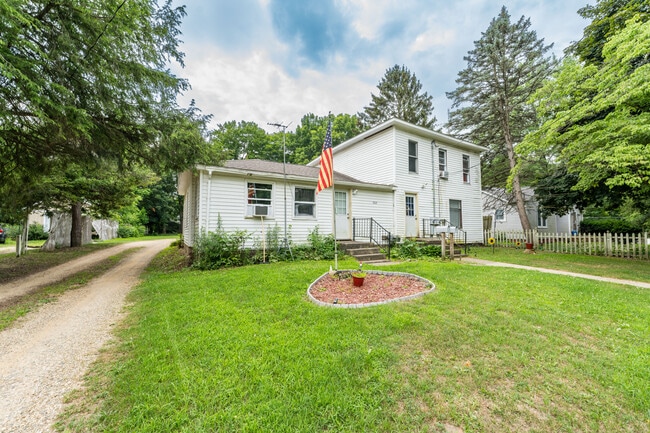
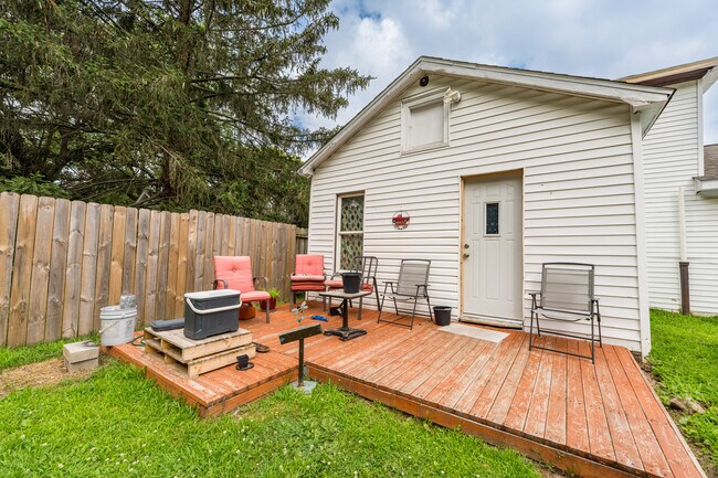
Property Record
302 E Saint Marys St, Decatur, MI 49045

NEARBY LISTINGS FOR SALE OR LEASE
-
-
View all Decatur listings for sale on LoopNet.com
Property Detail
302 E Saint Marys St
80-43-040-562-00
Original Of Decatur
Sfr
937-A 20-4-14 357-33 494-550 889-752 1224-446 1320-590 1382-667,668 LOT 10. EXCEPT W 4 FT OF N 138 FT THEREOF BLOCK T
X
Van Buren
26159C0450C
Michigan
2024
10
2025
0.24 AC
011601
Outer Van Buren County
2,546 SF
West Michigan
DEMOGRAPHICS near 302 E Saint Marys St
1 mile
3 mile
5 mile
2024 Total Population
1,933
3,167
5,151
2029 Population
1,918
3,162
5,193
Pop Growth 2024-2029
(0.78%)
(0.16%)
+ 0.82%
Average Age
41
42
43
2024 Total Households
767
1,248
2,035
HH Growth 2024-2029
(1.04%)
(0.56%)
+ 0.54%
Median Household Inc
$65,742
$66,237
$66,637
Avg Household Size
2.50
2.50
2.50
2024 Avg HH Vehicles
2.00
2.00
2.00
Median Home Value
$148,553
$163,625
$187,160
Median Year Built
1954
1960
1968
Nearby Places
Map Layers
Map Styles
 Street
 Aerial
Transit
 Traffic
 Biking
Places
Listings with unknown addresses are not visible on the map
- Restaurants
- Banks
- Shops
- Fitness
- Groceries
PUBLIC TRANSPORTATION
AIRPORT
Kalamazoo/Battle Creek International
Drive
Walk
Distance
Kalamazoo/Battle Creek International
40 min
29.2 mi
South Bend International
Drive
Walk
Distance
South Bend International
72 min
43.8 mi
SALE & LEASE HISTORY
LISTING DATE
SALE/LEASE

Jul 16, 2025
For Sale
Nearby Properties
Address
Land Use
TOTAL SIZE
Lot Size
Zoning
Address
Land Use
TOTAL SIZE
Lot Size
Zoning
9,284 SF
2.31 AC
Address
Land Use
TOTAL SIZE
Lot Size
Zoning
4,810 SF
53.26 AC
C-1
Address
Land Use
TOTAL SIZE
Lot Size
Zoning
4,970 SF
269 AC
Address
Land Use
TOTAL SIZE
Lot Size
Zoning
2,160 SF
20.38 AC
Address
Land Use
TOTAL SIZE
Lot Size
Zoning
7,590 SF
7.43 AC
C-1
Address
Land Use
TOTAL SIZE
Lot Size
Zoning
1,680 SF
32.97 AC
C-1
Address
Land Use
TOTAL SIZE
Lot Size
Zoning
4,970 SF
229 AC
Address
Land Use
TOTAL SIZE
Lot Size
Zoning
3,729 SF
4.60 AC
Address
Land Use
TOTAL SIZE
Lot Size
Zoning
291.73 AC
AG
Address
Land Use
TOTAL SIZE
Lot Size
Zoning
5,015 SF
0.58 AC
R-4
Address
Land Use
TOTAL SIZE
Lot Size
Zoning
2,522 SF
189.06 AC
Address
Land Use
TOTAL SIZE
Lot Size
Zoning
11,796 SF
2.12 AC
Address
Land Use
TOTAL SIZE
Lot Size
Zoning
101,880 SF
3.30 AC
Address
Land Use
TOTAL SIZE
Lot Size
Zoning
840 SF
82 AC
Address
Land Use
TOTAL SIZE
Lot Size
Zoning
62,566 SF
20 AC
Address
Land Use
TOTAL SIZE
Lot Size
Zoning
0.88 AC
Address
Land Use
TOTAL SIZE
Lot Size
Zoning
203.94 AC
Address
Land Use
TOTAL SIZE
Lot Size
Zoning
3,233 SF
20.30 AC
C-1
Address
Land Use
TOTAL SIZE
Lot Size
Zoning
4,239 SF
0.21 AC
Address
Land Use
TOTAL SIZE
Lot Size
Zoning
218 AC
AG
Address
Land Use
TOTAL SIZE
Lot Size
Zoning
2,134 SF
0.47 AC
R-4
Address
Land Use
TOTAL SIZE
Lot Size
Zoning
2,128 SF
1 AC
R-4
Address
Land Use
TOTAL SIZE
Lot Size
Zoning
2,700 SF
0.21 AC
Address
Land Use
TOTAL SIZE
Lot Size
Zoning
130 AC
Address
Land Use
TOTAL SIZE
Lot Size
Zoning
185.86 AC
AG
Address
Land Use
TOTAL SIZE
Lot Size
Zoning
10,539 SF
17.90 AC
1&2FAM
Address
Land Use
TOTAL SIZE
Lot Size
Zoning
2,286 SF
0.46 AC
R-4
Address
Land Use
TOTAL SIZE
Lot Size
Zoning
3,729 SF
75.02 AC
Address
Land Use
TOTAL SIZE
Lot Size
Zoning
1,320 SF
1 AC
R-4
Address
Land Use
TOTAL SIZE
Lot Size
Zoning
3,494 SF
0.35 AC
The World's #1 Commercial Real Estate Marketplace
Connect with us
© 2026 CoStar Group
The information above has been obtained from sources believed reliable. While we do not doubt its accuracy we have not verified it and make no guarantee, warranty or representation about it. It is your responsibility to independently confirm its accuracy and completeness. Any projections, opinions, assumptions, or estimates used are for example only and do not represent the current or future performance of the property. The value of this transaction to you depends on tax and other factors which should be evaluated by your tax, financial, and legal advisors. You and your advisors should conduct a careful, independent investigation of the property to determine to your satisfaction the suitability of the property for your needs.