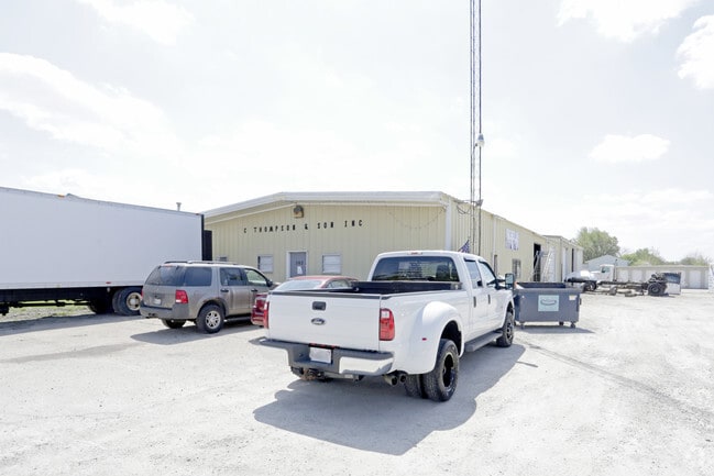
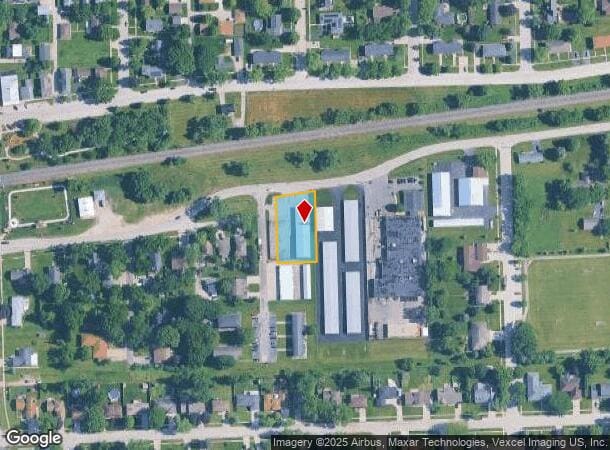
Property Record
302 E Wapella St, Minooka, IL 60447

NEARBY LISTINGS FOR SALE OR LEASE
-
-
View all Minooka listings for lease on LoopNet.com
Property Detail
302 E Wapella St
Chicago-Naperville-Elgin, IL-IN
Str
03-01-405-009
Grundy
Ruralagriculturalresidence
Illinois
X
0.53 AC
17093C0225H
Grundy County
5,880 SF
Chicago
DEMOGRAPHICS near 302 E Wapella St
1 Mile
3 Mile
5 Mile
2024 Total Population
3,562
21,676
40,754
2029 Population
3,530
22,000
41,257
Pop Growth 2024-2029
(0.90%)
+ 1.49%
+ 1.23%
Average Age
40
37
39
2024 Total Households
1,236
7,229
14,032
HH Growth 2024-2029
(0.89%)
+ 1.37%
+ 1.10%
Median Household Inc
$97,214
$101,284
$104,216
Avg Household Size
2.80
3.00
2.90
2024 Avg HH Vehicles
3.00
2.00
2.00
Median Home Value
$252,008
$255,273
$273,407
Median Year Built
1989
2000
2000
Nearby Places
Map Layers
Map Styles
 Street
 Aerial
- Restaurants
- Banks
- Shops
- Fitness
- Groceries
PUBLIC TRANSPORTATION
AIRPORT
Chicago Midway International
DRIVE
WALK
Distance
Chicago Midway International
55 min
41.8 mi
SALE & LEASE HISTORY
LISTING DATE
SALE/LEASE

Oct 19, 2018
For Sale
Nov 26, 2025
For Lease
Jun 07, 2024
For Lease
Nearby Properties
Address
Land Use
TOTAL SIZE
Lot Size
Zoning
Address
Land Use
TOTAL SIZE
Lot Size
Zoning
73.42 AC
Address
Land Use
TOTAL SIZE
Lot Size
Zoning
79.57 AC
Address
Land Use
TOTAL SIZE
Lot Size
Zoning
79.79 AC
Address
Land Use
TOTAL SIZE
Lot Size
Zoning
364 SF
48.93 AC
Address
Land Use
TOTAL SIZE
Lot Size
Zoning
19.57 AC
Address
Land Use
TOTAL SIZE
Lot Size
Zoning
1,034,100 SF
54.99 AC
Address
Land Use
TOTAL SIZE
Lot Size
Zoning
1,000,800 SF
24.66 AC
Address
Land Use
TOTAL SIZE
Lot Size
Zoning
15,600 SF
7.60 AC
Address
Land Use
TOTAL SIZE
Lot Size
Zoning
35.52 AC
Address
Land Use
TOTAL SIZE
Lot Size
Zoning
872,032 SF
43.10 AC
Address
Land Use
TOTAL SIZE
Lot Size
Zoning
598,380 SF
32.69 AC
Address
Land Use
TOTAL SIZE
Lot Size
Zoning
861,000 SF
47.22 AC
Address
Land Use
TOTAL SIZE
Lot Size
Zoning
306,240 SF
19.99 AC
Address
Land Use
TOTAL SIZE
Lot Size
Zoning
456,860 SF
35.47 AC
Address
Land Use
TOTAL SIZE
Lot Size
Zoning
175.60 AC
Address
Land Use
TOTAL SIZE
Lot Size
Zoning
107,428 SF
17.69 AC
Address
Land Use
TOTAL SIZE
Lot Size
Zoning
16.48 AC
Address
Land Use
TOTAL SIZE
Lot Size
Zoning
134,300 SF
18.29 AC
Address
Land Use
TOTAL SIZE
Lot Size
Zoning
24.22 AC
Address
Land Use
TOTAL SIZE
Lot Size
Zoning
60,804 SF
7.29 AC
Address
Land Use
TOTAL SIZE
Lot Size
Zoning
77,000 SF
7.43 AC
Address
Land Use
TOTAL SIZE
Lot Size
Zoning
3.91 AC
Address
Land Use
TOTAL SIZE
Lot Size
Zoning
422.38 AC
Address
Land Use
TOTAL SIZE
Lot Size
Zoning
Address
Land Use
TOTAL SIZE
Lot Size
Zoning
59,138 SF
3.19 AC
Address
Land Use
TOTAL SIZE
Lot Size
Zoning
Address
Land Use
TOTAL SIZE
Lot Size
Zoning
Address
Land Use
TOTAL SIZE
Lot Size
Zoning
22,925 SF
4.71 AC
Address
Land Use
TOTAL SIZE
Lot Size
Zoning
11,665 SF
10.79 AC
Address
Land Use
TOTAL SIZE
Lot Size
Zoning
The World's #1 Commercial Real Estate Marketplace
Connect with us
© 2026 CoStar Group
The information above has been obtained from sources believed reliable. While we do not doubt its accuracy we have not verified it and make no guarantee, warranty or representation about it. It is your responsibility to independently confirm its accuracy and completeness. Any projections, opinions, assumptions, or estimates used are for example only and do not represent the current or future performance of the property. The value of this transaction to you depends on tax and other factors which should be evaluated by your tax, financial, and legal advisors. You and your advisors should conduct a careful, independent investigation of the property to determine to your satisfaction the suitability of the property for your needs.