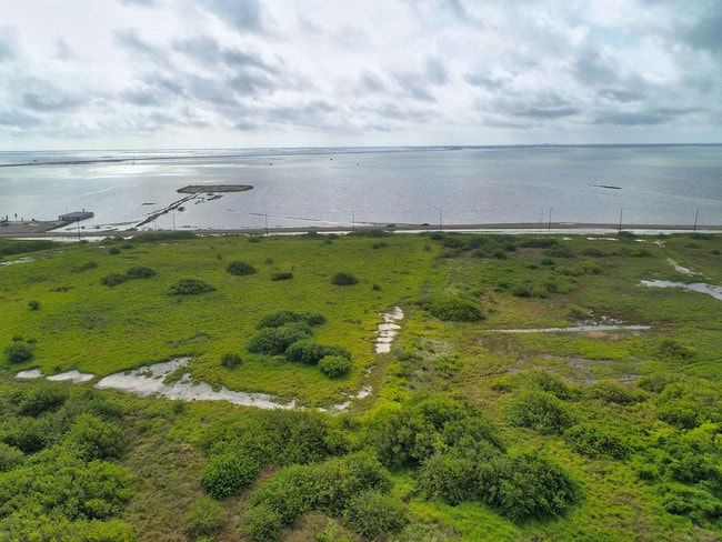
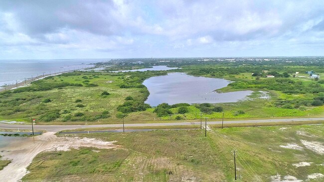
Property Record
302 Graham Rd, Corpus Christi, TX 78418

Property Detail
302 Graham Rd
233165
FLOUR BLUFF & ENC FRM GDN TRACT 21.13 ACS OUT LTS 9 & 1O SEC 55
Commercialnec
NUECES
A1
Texas
C and X Area of minimal flood hazard, usually depicted on FIRMs as above the 500-year flood level.
9&10
2024
21.13 AC
2025
Flour Bluff/Padre Island
003002
Corpus Christi
1,841 SF
Corpus Christi, TX
NEARBY LISTINGS FOR SALE OR LEASE
DEMOGRAPHICS near 302 Graham Rd
1 mile
3 mile
5 mile
2025 Total Population
2,202
19,650
50,454
2030 Population
2,218
19,586
50,464
Pop Growth 2025-2030
+ 0.73%
(0.33%)
+ 0.02%
Average Age
42
39
38
2025 Total Households
917
7,541
19,147
HH Growth 2025-2030
+ 0.65%
(0.44%)
(0.13%)
Median Household Inc
$40,954
$65,437
$88,730
Avg Household Size
2.30
2.50
2.40
2025 Avg HH Vehicles
1.00
2.00
2.00
Median Home Value
$142,657
$204,148
$271,806
Median Year Built
1990
1985
1993
Nearby Places
Map Layers
Map Styles
 Street
 Aerial
Transit
 Traffic
 Biking
Places
Listings with unknown addresses are not visible on the map
- Restaurants
- Banks
- Shops
- Fitness
- Groceries
PUBLIC TRANSPORTATION
AIRPORT
Corpus Christi International
Drive
Walk
Distance
Corpus Christi International
26 min
18.2 mi
Freight Ports
Port of Corpus Christi
Drive
Walk
Distance
Port of Corpus Christi
21 min
14.1 mi
SALE & LEASE HISTORY
LISTING DATE
SALE/LEASE

Jun 19, 2019
For Sale
Feb 09, 2021
For Sale
Nearby Properties
Address
Land Use
TOTAL SIZE
Lot Size
Zoning
Address
Land Use
TOTAL SIZE
Lot Size
Zoning
754,977 SF
93 AC
VII
Address
Land Use
TOTAL SIZE
Lot Size
Zoning
2,001.86 AC
R1B
Address
Land Use
TOTAL SIZE
Lot Size
Zoning
2,884 SF
621 AC
R-1B
Address
Land Use
TOTAL SIZE
Lot Size
Zoning
60,829 SF
44.79 AC
Address
Land Use
TOTAL SIZE
Lot Size
Zoning
158,613 SF
17.15 AC
Address
Land Use
TOTAL SIZE
Lot Size
Zoning
32,204 SF
5.52 AC
Address
Land Use
TOTAL SIZE
Lot Size
Zoning
147,716 SF
13.67 AC
B-3&SP,B-4
Address
Land Use
TOTAL SIZE
Lot Size
Zoning
58,500 SF
3.06 AC
B-3
Address
Land Use
TOTAL SIZE
Lot Size
Zoning
Address
Land Use
TOTAL SIZE
Lot Size
Zoning
6,186 SF
11.85 AC
T-1B
Address
Land Use
TOTAL SIZE
Lot Size
Zoning
3,500 SF
11.09 AC
B-4
Address
Land Use
TOTAL SIZE
Lot Size
Zoning
33,036 SF
4.97 AC
B-4
Address
Land Use
TOTAL SIZE
Lot Size
Zoning
55,261 SF
1.82 AC
B-3
Address
Land Use
TOTAL SIZE
Lot Size
Zoning
29,414 SF
2.47 AC
B-3
Address
Land Use
TOTAL SIZE
Lot Size
Zoning
5.76 AC
I3
Address
Land Use
TOTAL SIZE
Lot Size
Zoning
42,517 SF
0.58 AC
B-3
Address
Land Use
TOTAL SIZE
Lot Size
Zoning
93,825 SF
5.48 AC
B-3
Address
Land Use
TOTAL SIZE
Lot Size
Zoning
68,074 SF
4.84 AC
Address
Land Use
TOTAL SIZE
Lot Size
Zoning
10.61 AC
B3
Address
Land Use
TOTAL SIZE
Lot Size
Zoning
4,000 SF
4 AC
Address
Land Use
TOTAL SIZE
Lot Size
Zoning
28.09 AC
B-4&R1-B
Address
Land Use
TOTAL SIZE
Lot Size
Zoning
3,657 SF
25.30 AC
Address
Land Use
TOTAL SIZE
Lot Size
Zoning
1,649 SF
24.20 AC
I2
Address
Land Use
TOTAL SIZE
Lot Size
Zoning
34,801 SF
8.34 AC
R1B
Address
Land Use
TOTAL SIZE
Lot Size
Zoning
26,391 SF
9.49 AC
B-3
Address
Land Use
TOTAL SIZE
Lot Size
Zoning
978 SF
40 AC
T1B
Address
Land Use
TOTAL SIZE
Lot Size
Zoning
39,240 SF
3.79 AC
B3
Address
Land Use
TOTAL SIZE
Lot Size
Zoning
2,016 SF
7 AC
Address
Land Use
TOTAL SIZE
Lot Size
Zoning
1,000 SF
6.21 AC
The World's #1 Commercial Real Estate Marketplace
Connect with us
© 2026 CoStar Group
The information above has been obtained from sources believed reliable. While we do not doubt its accuracy we have not verified it and make no guarantee, warranty or representation about it. It is your responsibility to independently confirm its accuracy and completeness. Any projections, opinions, assumptions, or estimates used are for example only and do not represent the current or future performance of the property. The value of this transaction to you depends on tax and other factors which should be evaluated by your tax, financial, and legal advisors. You and your advisors should conduct a careful, independent investigation of the property to determine to your satisfaction the suitability of the property for your needs.