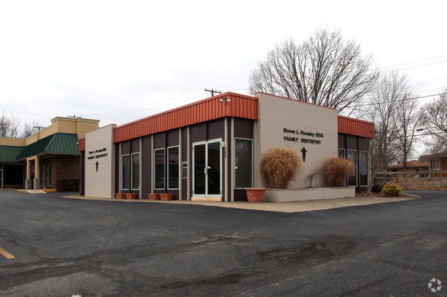
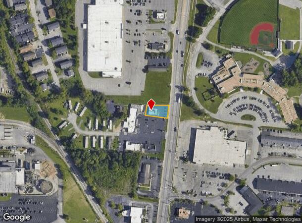
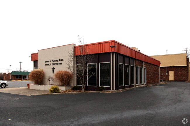
Property Record
302 Grant Line Ctr, New Albany, IN 47150
NEARBY LISTINGS FOR SALE OR LEASE
Property Detail
302 Grant Line Ctr
22-05-02-300-067.000-008
PRT. NW 1/4 23-2-6 .228 A.
Medicalbuilding
Floyd
X
Indiana
18019C0275E
0.23 AC
2024
New Albany
2024
Louisville
070901
Louisville-Jefferson County, KY-IN
1,785 SF
DEMOGRAPHICS near 302 Grant Line Ctr
1 Mile
3 Mile
5 Mile
2024 Total Population
7,750
54,714
111,921
2029 Population
7,807
55,849
115,116
Pop Growth 2024-2029
+ 0.74%
+ 2.07%
+ 2.85%
Average Age
40
40
41
2024 Total Households
3,201
23,299
46,028
HH Growth 2024-2029
+ 0.62%
+ 2.13%
+ 2.89%
Median Household Inc
$60,754
$51,361
$52,394
Avg Household Size
2.30
2.20
2.30
2024 Avg HH Vehicles
2.00
2.00
2.00
Median Home Value
$170,954
$161,829
$167,046
Median Year Built
1975
1969
1970
Nearby Places
Map Layers
Map Styles
 Street
 Aerial
- Restaurants
- Banks
- Shops
- Fitness
- Groceries
PUBLIC TRANSPORTATION
AIRPORT
Louisville Muhammad Ali International
DRIVE
WALK
Distance
Louisville Muhammad Ali International
27 min
17.9 mi
Freight Ports
Port of Toledo
DRIVE
WALK
Distance
Port of Toledo
355 min
308.2 mi
Nearby Properties
Address
Land Use
TOTAL SIZE
Lot Size
Zoning
Address
Land Use
TOTAL SIZE
Lot Size
Zoning
3,452 SF
13.22 AC
Address
Land Use
TOTAL SIZE
Lot Size
Zoning
175,626 SF
60.10 AC
Address
Land Use
TOTAL SIZE
Lot Size
Zoning
2,000 SF
13.11 AC
Address
Land Use
TOTAL SIZE
Lot Size
Zoning
12,270 SF
13.50 AC
Address
Land Use
TOTAL SIZE
Lot Size
Zoning
25,728 SF
10.37 AC
Address
Land Use
TOTAL SIZE
Lot Size
Zoning
56,775 SF
5.30 AC
Address
Land Use
TOTAL SIZE
Lot Size
Zoning
11,695 SF
18.33 AC
Address
Land Use
TOTAL SIZE
Lot Size
Zoning
4,512 SF
17.76 AC
Address
Land Use
TOTAL SIZE
Lot Size
Zoning
75,560 SF
8.18 AC
Address
Land Use
TOTAL SIZE
Lot Size
Zoning
1.84 AC
Address
Land Use
TOTAL SIZE
Lot Size
Zoning
9,900 SF
11.23 AC
Address
Land Use
TOTAL SIZE
Lot Size
Zoning
270,377 SF
17.54 AC
Address
Land Use
TOTAL SIZE
Lot Size
Zoning
204,750 SF
26.96 AC
Address
Land Use
TOTAL SIZE
Lot Size
Zoning
3,692 SF
15.99 AC
Address
Land Use
TOTAL SIZE
Lot Size
Zoning
58,884 SF
7.92 AC
Address
Land Use
TOTAL SIZE
Lot Size
Zoning
81,000 SF
44.74 AC
Address
Land Use
TOTAL SIZE
Lot Size
Zoning
143,700 SF
0.29 AC
Address
Land Use
TOTAL SIZE
Lot Size
Zoning
86,719 SF
7.04 AC
Address
Land Use
TOTAL SIZE
Lot Size
Zoning
202,859 SF
22.95 AC
Address
Land Use
TOTAL SIZE
Lot Size
Zoning
43,204 SF
6.95 AC
Address
Land Use
TOTAL SIZE
Lot Size
Zoning
2,300 SF
15.14 AC
Address
Land Use
TOTAL SIZE
Lot Size
Zoning
67,471 SF
7 AC
Address
Land Use
TOTAL SIZE
Lot Size
Zoning
80,812 SF
10.05 AC
Address
Land Use
TOTAL SIZE
Lot Size
Zoning
169 SF
35.25 AC
Address
Land Use
TOTAL SIZE
Lot Size
Zoning
44,144 SF
6.26 AC
Address
Land Use
TOTAL SIZE
Lot Size
Zoning
34,308 SF
4.59 AC
Address
Land Use
TOTAL SIZE
Lot Size
Zoning
72,332 SF
2.48 AC
Address
Land Use
TOTAL SIZE
Lot Size
Zoning
124,880 SF
10.06 AC
Address
Land Use
TOTAL SIZE
Lot Size
Zoning
83,084 SF
14.65 AC
Address
Land Use
TOTAL SIZE
Lot Size
Zoning
27,132 SF
4.27 AC
The World's #1 Commercial Real Estate Marketplace
Connect with us
© 2025 CoStar Group
The information above has been obtained from sources believed reliable. While we do not doubt its accuracy we have not verified it and make no guarantee, warranty or representation about it. It is your responsibility to independently confirm its accuracy and completeness. Any projections, opinions, assumptions, or estimates used are for example only and do not represent the current or future performance of the property. The value of this transaction to you depends on tax and other factors which should be evaluated by your tax, financial, and legal advisors. You and your advisors should conduct a careful, independent investigation of the property to determine to your satisfaction the suitability of the property for your needs.