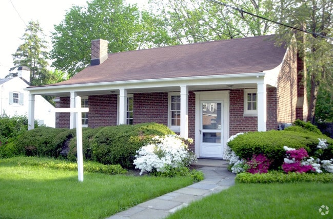
Property Record
302 Main St, Chatham, NJ 07928

Property Detail
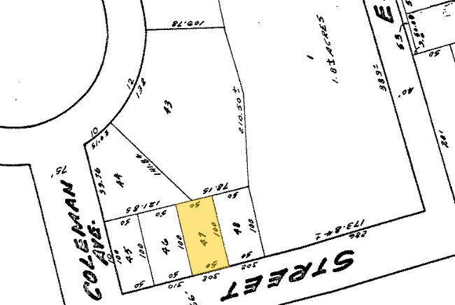
302 Main St
04-00064-0000-00047
Morris
Medicalbuilding
New Jersey
B-1
47
2024
0.12 AC
2025
Short Hills/Millburn
042700
Northern New Jersey
1,138 SF
Newark, NJ
NEARBY LISTINGS FOR SALE OR LEASE
DEMOGRAPHICS near 302 Main St
1 mile
3 mile
5 mile
2025 Total Population
11,735
82,631
181,343
2030 Population
12,088
86,215
190,451
Pop Growth 2025-2030
+ 3.01%
+ 4.34%
+ 5.02%
Average Age
39
40
41
2025 Total Households
3,931
28,602
63,980
HH Growth 2025-2030
+ 3.03%
+ 4.45%
+ 5.04%
Median Household Inc
$234,693
$198,553
$191,214
Avg Household Size
2.90
2.80
2.70
2025 Avg HH Vehicles
2.00
2.00
2.00
Median Home Value
$937,730
$942,610
$850,030
Median Year Built
1951
1959
1962
Nearby Places
Map Layers
Map Styles
 Street
 Aerial
Layers
 Traffic
 Biking
Places
Listings with unknown addresses are not visible on the map
- Restaurants
- Banks
- Shops
- Fitness
- Groceries
PUBLIC TRANSPORTATION
TRANSIT/SUBWAY
Chatham (Morris & Essex Morristown Line - NJ Transit Commuter Rail (NJ Transit))
Drive
Walk
Distance
Chatham (Morris & Essex Morristown Line - NJ Transit Commuter Rail (NJ Transit))
0 min
2 min
0.1 mi
COMMUTER RAIL
Chatham (Morris & Essex Morristown Line - NJ Transit Commuter Rail (NJ Transit))
Drive
Walk
Distance
Chatham (Morris & Essex Morristown Line - NJ Transit Commuter Rail (NJ Transit))
1 min
3 min
0.1 mi
Madison (Morris & Essex Morristown Line - NJ Transit Commuter Rail (NJ Transit))
Drive
Walk
Distance
Madison (Morris & Essex Morristown Line - NJ Transit Commuter Rail (NJ Transit))
5 min
2.1 mi
AIRPORT
Newark Liberty International
Drive
Walk
Distance
Newark Liberty International
20 min
14.8 mi
LaGuardia
Drive
Walk
Distance
LaGuardia
56 min
34.0 mi
John F Kennedy International
Drive
Walk
Distance
John F Kennedy International
67 min
42.2 mi
Freight Ports
Maher Terminal
Drive
Walk
Distance
Maher Terminal
25 min
15.9 mi
Nearby Properties
Address
Land Use
TOTAL SIZE
Lot Size
Zoning
Address
Land Use
TOTAL SIZE
Lot Size
Zoning
46.18 AC
Address
Land Use
TOTAL SIZE
Lot Size
Zoning
66,201 SF
168.40 AC
R-3
Address
Land Use
TOTAL SIZE
Lot Size
Zoning
1,968 SF
88.85 AC
PROD
Address
Land Use
TOTAL SIZE
Lot Size
Zoning
64.30 AC
MF-4
Address
Land Use
TOTAL SIZE
Lot Size
Zoning
4,595 SF
4.57 AC
M-3
Address
Land Use
TOTAL SIZE
Lot Size
Zoning
7.19 AC
PI
Address
Land Use
TOTAL SIZE
Lot Size
Zoning
42.64 AC
D-S
Address
Land Use
TOTAL SIZE
Lot Size
Zoning
4.30 AC
OR-3
Address
Land Use
TOTAL SIZE
Lot Size
Zoning
31.03 AC
R-L
Address
Land Use
TOTAL SIZE
Lot Size
Zoning
50.01 AC
PCDO
Address
Land Use
TOTAL SIZE
Lot Size
Zoning
19.05 AC
R-2
Address
Land Use
TOTAL SIZE
Lot Size
Zoning
Address
Land Use
TOTAL SIZE
Lot Size
Zoning
270,000 SF
15.32 AC
OR
Address
Land Use
TOTAL SIZE
Lot Size
Zoning
59,369 SF
86.79 AC
R-44
Address
Land Use
TOTAL SIZE
Lot Size
Zoning
18.98 AC
R-5B
Address
Land Use
TOTAL SIZE
Lot Size
Zoning
296,578 SF
15 AC
Address
Land Use
TOTAL SIZE
Lot Size
Zoning
Address
Land Use
TOTAL SIZE
Lot Size
Zoning
Address
Land Use
TOTAL SIZE
Lot Size
Zoning
17.26 AC
R-L
Address
Land Use
TOTAL SIZE
Lot Size
Zoning
7.52 AC
OR-3
Address
Land Use
TOTAL SIZE
Lot Size
Zoning
60 AC
R-L
Address
Land Use
TOTAL SIZE
Lot Size
Zoning
20 AC
PCDO
Address
Land Use
TOTAL SIZE
Lot Size
Zoning
15.50 AC
R-1
Address
Land Use
TOTAL SIZE
Lot Size
Zoning
252,828 SF
44.53 AC
C-1
Address
Land Use
TOTAL SIZE
Lot Size
Zoning
40.90 AC
MF-4
Address
Land Use
TOTAL SIZE
Lot Size
Zoning
146,538 SF
20 AC
PCDO
Address
Land Use
TOTAL SIZE
Lot Size
Zoning
9.44 AC
Address
Land Use
TOTAL SIZE
Lot Size
Zoning
19.14 AC
Address
Land Use
TOTAL SIZE
Lot Size
Zoning
24.60 AC
R-L
Address
Land Use
TOTAL SIZE
Lot Size
Zoning
15.39 AC
R-7
The World's #1 Commercial Real Estate Marketplace
Connect with us
© 2026 CoStar Group
The information above has been obtained from sources believed reliable. While we do not doubt its accuracy we have not verified it and make no guarantee, warranty or representation about it. It is your responsibility to independently confirm its accuracy and completeness. Any projections, opinions, assumptions, or estimates used are for example only and do not represent the current or future performance of the property. The value of this transaction to you depends on tax and other factors which should be evaluated by your tax, financial, and legal advisors. You and your advisors should conduct a careful, independent investigation of the property to determine to your satisfaction the suitability of the property for your needs.