Property Record
302 Manatee Ave E, Bradenton, FL 34208
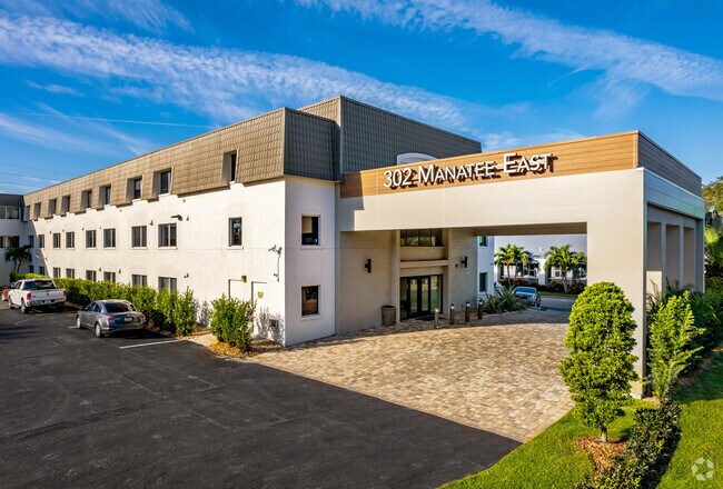


Property Detail
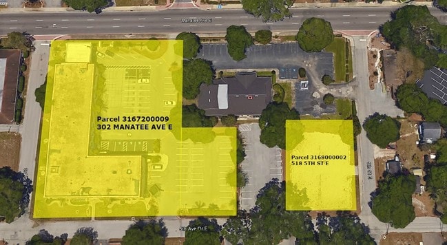
302 Manatee Ave E
31672-0000-9
PARCEL 1: LOTS 1-5 INCL THE N1/2 OF VAC ALLEY ADJACENT THERETO, EXCEPT THE N 7 FT OF SD LOTS 1-5 & W 10 FT OF SD LOT 1, PARCEL 2: LOTS 18-22 INCL THE S1/2 OF VAC ALLEY
Officebuilding
Manatee
BR_FBC,BR_
Florida
B and X Area of moderate flood hazard, usually the area between the limits of the 100-year and 500-year floods.
1
2024
1.49 AC
2025
Manatee
000703
Tampa/St Petersburg
45,228 SF
North Port-Bradenton-Sarasota, FL
NEARBY LISTINGS FOR SALE OR LEASE
DEMOGRAPHICS near 302 Manatee Ave E
1 mile
3 mile
5 mile
2025 Total Population
7,277
94,359
221,079
2030 Population
8,155
105,440
246,749
Pop Growth 2025-2030
+ 12.07%
+ 11.74%
+ 11.61%
Average Age
39
42
44
2025 Total Households
2,913
37,583
92,712
HH Growth 2025-2030
+ 12.67%
+ 12.10%
+ 11.96%
Median Household Inc
$58,372
$54,083
$60,160
Avg Household Size
2.30
2.40
2.30
2025 Avg HH Vehicles
2.00
2.00
2.00
Median Home Value
$274,589
$249,645
$291,509
Median Year Built
1992
1977
1982
Nearby Places
Map Layers
Map Styles
 Street
 Aerial
Transit
 Traffic
 Biking
Places
Listings with unknown addresses are not visible on the map
- Restaurants
- Banks
- Shops
- Fitness
- Groceries
PUBLIC TRANSPORTATION
AIRPORT
Sarasota/Bradenton International
Drive
Walk
Distance
Sarasota/Bradenton International
18 min
8.6 mi
St Pete-Clearwater International
Drive
Walk
Distance
St Pete-Clearwater International
46 min
35.2 mi
Tampa International
Drive
Walk
Distance
Tampa International
58 min
44.5 mi
Freight Ports
Port Manatee
Drive
Walk
Distance
Port Manatee
19 min
11.4 mi
SALE & LEASE HISTORY
LISTING DATE
SALE/LEASE

Sep 25, 2016
For Lease
Sep 24, 2016
For Sale
Oct 02, 2017
For Sale
Jan 26, 2017
For Lease
Jan 26, 2017
For Sale
Aug 29, 2017
For Sale
Aug 07, 2018
For Lease
Nearby Properties
Address
Land Use
TOTAL SIZE
Lot Size
Zoning
Address
Land Use
TOTAL SIZE
Lot Size
Zoning
881,490 SF
83.09 AC
BR_R-3
Address
Land Use
TOTAL SIZE
Lot Size
Zoning
595,475 SF
16.90 AC
BR_T5
Address
Land Use
TOTAL SIZE
Lot Size
Zoning
349,711 SF
49.51 AC
BR_SD1
Address
Land Use
TOTAL SIZE
Lot Size
Zoning
405,843 SF
9.09 AC
BR_T5
Address
Land Use
TOTAL SIZE
Lot Size
Zoning
277,678 SF
7.80 AC
BR_T4-O, B
Address
Land Use
TOTAL SIZE
Lot Size
Zoning
427,250 SF
38.18 AC
A-1 SUBURB
Address
Land Use
TOTAL SIZE
Lot Size
Zoning
98,722 SF
10.24 AC
PL_P
Address
Land Use
TOTAL SIZE
Lot Size
Zoning
432,078 SF
1.64 AC
BR_T6
Address
Land Use
TOTAL SIZE
Lot Size
Zoning
169,485 SF
7.87 AC
PD-MU
Address
Land Use
TOTAL SIZE
Lot Size
Zoning
318,507 SF
10.47 AC
BR_T4R,BR_
Address
Land Use
TOTAL SIZE
Lot Size
Zoning
2,401,721 SF
142.14 AC
PD-UI
Address
Land Use
TOTAL SIZE
Lot Size
Zoning
257,072 SF
10.07 AC
BR_T5
Address
Land Use
TOTAL SIZE
Lot Size
Zoning
397,863 SF
21.60 AC
GC GENERA
Address
Land Use
TOTAL SIZE
Lot Size
Zoning
541,781 SF
3.48 AC
BR_T5
Address
Land Use
TOTAL SIZE
Lot Size
Zoning
885,776 SF
46.22 AC
LM LIGHT M
Address
Land Use
TOTAL SIZE
Lot Size
Zoning
318,680 SF
1.31 AC
BR_FBC,BR_
Address
Land Use
TOTAL SIZE
Lot Size
Zoning
499,823 SF
39.50 AC
PL_P
Address
Land Use
TOTAL SIZE
Lot Size
Zoning
247,592 SF
13.39 AC
GC,RMF-6
Address
Land Use
TOTAL SIZE
Lot Size
Zoning
198,036 SF
8.32 AC
GC GENERA
Address
Land Use
TOTAL SIZE
Lot Size
Zoning
115,400 SF
22.55 AC
LM LIGHT M
Address
Land Use
TOTAL SIZE
Lot Size
Zoning
185,617 SF
13.68 AC
BR_R-2
Address
Land Use
TOTAL SIZE
Lot Size
Zoning
187,000 SF
8.93 AC
Address
Land Use
TOTAL SIZE
Lot Size
Zoning
166,810 SF
3.16 AC
BR_T4-O
Address
Land Use
TOTAL SIZE
Lot Size
Zoning
276,469 SF
10.90 AC
PD-MU
Address
Land Use
TOTAL SIZE
Lot Size
Zoning
485,150 SF
56.44 AC
HC,GC
Address
Land Use
TOTAL SIZE
Lot Size
Zoning
163,582 SF
8.61 AC
PL_P
Address
Land Use
TOTAL SIZE
Lot Size
Zoning
196,346 SF
33.03 AC
BR_R-1
Address
Land Use
TOTAL SIZE
Lot Size
Zoning
145,200 SF
8.66 AC
Address
Land Use
TOTAL SIZE
Lot Size
Zoning
148,992 SF
9.81 AC
RMF-9,GC
Address
Land Use
TOTAL SIZE
Lot Size
Zoning
183,257 SF
4.19 AC
PD-R
The World's #1 Commercial Real Estate Marketplace
Connect with us
© 2026 CoStar Group
The information above has been obtained from sources believed reliable. While we do not doubt its accuracy we have not verified it and make no guarantee, warranty or representation about it. It is your responsibility to independently confirm its accuracy and completeness. Any projections, opinions, assumptions, or estimates used are for example only and do not represent the current or future performance of the property. The value of this transaction to you depends on tax and other factors which should be evaluated by your tax, financial, and legal advisors. You and your advisors should conduct a careful, independent investigation of the property to determine to your satisfaction the suitability of the property for your needs.